Current Weather/Notams (Metars, TAFs, Notams, NWS Forecast, PIREPS, and nearby weather)
Customs Information Send updates to Support@FltPlan.com
Customs Not Available
Database effective 04/18/2024
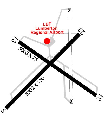
Airport Diagram might not be current. Facility Name: LUMBERTON RGNL City Name: LUMBERTON County: ROBESON State abbrev: NC State Name: NORTH CAROLINA Ownership: PUBLICLY OWNED Use: OPEN TO THE PUBLIC Owner's Name: CITY OF LUMBERTON Address: P. O. BOX 1388 LUMBERTON, NC 28359 Owner's Phone: 910-671-3800 Manager's Name: GARY LEWIS Address: 163 AIRPORT BLVD LUMBERTON, NC 28358 Phone: 910-739-6480 FAA Region: SOUTHERN FAA Field Office: MEM
Runway Identifications Help
Runway Identification: 05/23 Length: 5502 ftWidth: 150 ftSurface: ASPHALTEdge lights: Medium Intensity Treatment: NONEWeight: PCN 22 /F/C/X/T Runway: 05 Runway: 23 Mag heading: 53° Mag heading: 233° Rwy Slope: .00% Down Rwy Slope: .00% Up Approach: ILS Approach: Pattern: Left Traffic Pattern: Left Traffic Markings: PRECISION INSTRUMENT Markings: PRECISION INSTRUMENT Marking Condition: GOOD Marking Condition: GOOD Arresting Dev: Arresting Dev: Lat & Long: N3436.3 W07904.0 Lat. & Long.: N3436.9 W07903.3 Elev: 123.2 ft. MSL Elev: 123.1 ft. MSL TCH: 60 ft. AGL TCH: 45 ft. AGL Visual Glide Path: 3.00 degrees Visual Glide Path: 3.20 degrees Displaced Threshold: 160 feet Displaced Threshold: No Touchdown Zone: YES Touchdown Zone: YES Touchdown Elev.: 124.2 feet Touchdown Elev.: 124.4 feet Visual Glide Slope: 4-Light PAPI on LEFT side of Runway Visual Glide Slope: 2-Light PAPI on LEFT side of Runway RVR Equipment: RVR Equipment: RVV Equipment: NO RVV Equipment: NO Approach Lights: Approach Lights: REIL: YES REIL: YES Centerline Lights: NO Centerline Lights: NO Touchdown lights: NO Touchdown lights: NO Runway Category: Precision Instrument Runway Runway Category: Runway with a Non-precision Approach having visibility minimums greater than 3/4 mile Declared Distances: Declared Distances: Obstructions: TREES Obstructions: TREES Marked: NOT Marked/Lighted Marked: NOT Marked/Lighted Clearance slope: 24:1; APCH RATIO 26:1 AT DSPLCD THR. Clearance slope: 9:1 Obstruction height: 78 feet AGL Obstruction height: 44 feet AGL Dist. from runway: 2140 feet Dist. from runway: 630 feet Centerline offset: 506 right of centerline Centerline offset: 178 feet left of centerline Comments: Comments: 56 FT TREES 0-200 FT FM THR OFFSET 233 FT LEFT.
Runway Identification: 13/31 Length: 5003 ftWidth: 75 ftSurface: ASPHALTEdge lights: Treatment: NONE Runway: 13 Runway: 31 Mag heading: 133° Mag heading: 313° Rwy Slope: -.05% Down Rwy Slope: .05% Up Approach: Approach: Pattern: Left Traffic Pattern: Left Traffic Markings: NONPRECISION INSTRUMENT Markings: NONPRECISION INSTRUMENT Marking Condition: GOOD Marking Condition: GOOD Arresting Dev: Arresting Dev: Lat & Long: N3436.8 W07903.9 Lat. & Long.: N3436.4 W07903.1 Elev: 123.7 ft. MSL Elev: 121.3 ft. MSL TCH: TCH: Visual Glide Path: Visual Glide Path: Displaced Threshold: No Displaced Threshold: 589 feet Touchdown Zone: YES Touchdown Zone: YES Touchdown Elev.: 124.5 feet Touchdown Elev.: 124.5 feet Visual Glide Slope: Visual Glide Slope: RVR Equipment: RVR Equipment: RVV Equipment: NO RVV Equipment: NO Approach Lights: Approach Lights: REIL: NO REIL: NO Centerline Lights: NO Centerline Lights: NO Touchdown lights: NO Touchdown lights: NO Runway Category: Runway with a Non-precision Approach Runway Category: Runway with a Visual Approach Declared Distances: Declared Distances: Obstructions: TREES Obstructions: TREES Marked: NOT Marked/Lighted Marked: NOT Marked/Lighted Clearance slope: 7:1 Clearance slope: 3:1; APCH RATIO 21:1 AT DSPLCD THR. Obstruction height: 38 feet AGL Obstruction height: 29 feet AGL Dist. from runway: 468 feet Dist. from runway: 297 feet Centerline offset: 155 left of centerline Centerline offset: 7 feet right of centerline Comments: 9 FT FENCE 100 FT TO 200 FT FM THR OFFSET 240 FT L AND R OF CNTRLN. Comments: 15 FT ROAD 170 FT FM THR BOTH SIDES AND 10 FT FENCE 154 FT FM THR BOTH SIDES.