Click here for more info on on SMS!

KLBE

ARNOLD PALMER RGNL
LATROBE
PA
Time Zone: Eastern
Lat: N 4016.4
Long: W 07924.6
Elev: 1199
Var: +10
Longest Runway: 8222
Dept. ATIS: 118.37
Arr. ATIS: 118.37
AWOS: 118.37
Ground: 121.8
Tower: 125.0

FBO & Flight Services info for KLBE

FBOs: Update your Fuel Prices

  click here  
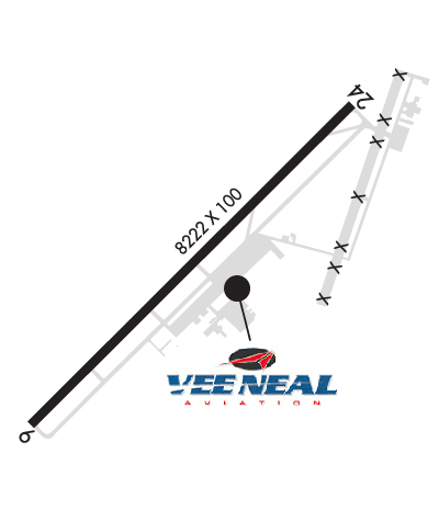
Laurel Highlands Jet Center operates the only full-service FBO at KLBE. Clients have come to rely upon the warm greetings & excellent service that they receive. The professional line staff is always ready to meet the needs of visiting passengers & crews. We offer a comfortable passenger lounge, crew lounge w/satellite TV, wifi, showering facilities, snooze room, conference room, and crew cars.
Ph: 724-539-4533 Fax: 724-539-4538 Freq: 130.12WebsiteE-Mail
                     
Service
Jet
100LL
SAF
MoGas
Fuel Avail: JET A w/PRIST + .06$ . 6 A-10 P, after hours call 724-771-9597
Full5.597.30    Last Update: 04/16/2024 07:59
PRICES GUARANTEED by FBO. *
*All fuel prices guaranteed
Self  6.80    
Misc. Info: Lowest fuel price guaranteed at LBE please call for discounts.
We are an Air Elite Diamond FBO
Address: 148 AVIATION LANE, SUITE 108,   LATROBE, PA 15650-9549

L J AVIATIONPh: 724-537-0520 Fax: 724-537-9504 Freq: 129.72
Service
Jet
100LL
SAF
MoGas
Fuel Avail: .20cent discount per gallon if you mention this advertisement.
Full5.12      Last Update: 04/16/2024 07:27  
Self        
 Address: 125 AVIATION LANE, SUITE 112,   LATROBE, PA 15650-9549
AWOSPh: 724-537-0671
-
Freq: 118.37  
If you are an FBO, call 1-203-262-1700 to update your info or email: FltPlan.Advertising@garmin.com
Advertise your FBO on FltPlan.com

Runway & Approach Info for KLBE
Rwy
Length
Land Dist**
Approach*
  Rwy
Length
Land Dist**
Approach*
06
8222x150  8222'          
 
  
24
  8222x150  7372'          
ILS
 110.90 - 235°  
 * only ILS, LOC, LDA, and SDF approaches to a specific runway are shown
** For any Declared Landing Distance Available, please see A/FD or Approach plates
Runway Weight Capability (lbs.) Help
Runway IDSingle WheelDouble WheelDouble Tandem WheelDual Double Wheel
06/24120,000198,000321,000N/A
These numbers are Advisory and are not limits.   The Airport Manager should have more accurate Weight Limits
Approach Charts
Approaches    
Current Weather/Notams
Customs Information Send updates to Support@FltPlan.com
Customs Not Available
Database effective 04/18/2024
Airport Diagram of KLBE
Airport Diagram might not be current.

Facility Name: ARNOLD PALMER RGNL
City Name: LATROBE
County: WESTMORELAND
State abbrev: PA
State Name: PENNSYLVANIA
   
Ownership: PUBLICLY OWNED
Use: OPEN TO THE PUBLIC
Owner's Name: WESTMORELAND COUNTY ARPT AUTH
Address: 148 AVIATION LANE, SUITE 103
 LATROBE, PA 15650-9549
Owner's Phone: 724-640-7234
  
Manager's Name: GABE MONZO
Address: 148 AVIATION LANE, SUITE 103
 LATROBE, PA 15650-9549
Phone: 724-539-8100
   
FAA Region: EASTERN
FAA Field Office: HAR


Sunrise / Sunset times for ARNOLD PALMER RGNL

DateSunriseSunset
04/19/24 Friday6:3220:01
04/20/24 Saturday6:3120:02
04/21/24 Sunday6:3020:03
04/22/24 Monday6:2820:04
04/23/24 Tuesday6:2720:06
04/24/24 Wednesday6:2520:07
04/25/24 Thursday6:2420:08
04/26/24 Friday6:2320:09
04/27/24 Saturday6:2120:10
04/28/24 Sunday6:2020:11
04/29/24 Monday6:1920:12
04/30/24 Tuesday6:1720:13
05/01/24 Wednesday6:1620:14
05/02/24 Thursday6:1520:15

Airport Facilities

Airport Attendance ScheduleCONTINUOUS
Airport Status OPERATIONAL (This Status can change at any time - please check NOTAMS)
Airport Lighting ScheduleWHEN ATCT CLSD, ACTVT MALSR RWY 24; REIL RWY 06; HIRL RWY 06/24; TWY A, B, C & D - CTAF.
Airport Storage AvailableTie Downs, Hanger
Extra Services AvailableAvionics, Charter, Flight Instruction, Aircraft Rental, Aircraft Sales
Wind IndicatorYES - (lighted)
Control TowerYES
CTAF Frequency125.000
Unicom Frequency
Rotating Beacon ColorWG
Segmented CircleNO
Landing FeeYES

Airport Inspection Data

Airport InspectedFEDERAL - performed by FAA AIRPORTS FIELD PERSONNEL
Inspection Date05/31/2023

Airport Services

Type of Fuel AvailableGrade 100LL, JET A (freeze point -40C)
Airframe Repair ServiceMAJOR
Power Plant Repair ServiceMAJOR

Geographic Data

LatitudeN4016.4
LongitudeW07924.6 (ESTIMATED)
Arpt Elevation1198ft (SURVEYED)
Magnetic Variation10W
2 miles SWof LATROBE
Traffic Pattern Altitude
Sectional ChartDETROIT

Aircraft Data

Operations (Reported)YearlyAvg. Daily
General Aviation Transient 1742548
General Aviation Local 1374538
Air Taxi 514514
Commerical 17705
Commuter 00
Military 7372
Aircraft based on Field
General Aviation Singles 91
General Aviation Multi 11
Jet Aircraft 31
General Aviation Helicopters 5
Military Aircraft 0
Gliders 0
Ultralights 0

FAA Services

FSS on field NO
FSS tie-in ALTOONA
FSS Phone 1-800-WX-BRIEF
Who issues Notams LBE
Notam D service at airport YES
ARTCC Name CLEVELAND

Federal Status

Airport CertificationAIRPORT RECEIVING SCHEDULED AIR CARRIER SERVICE FROM CARRIERS CERTIFICATED BY THE CIVIL AERONAUTICS BOARD; PPR 24 FOR UNSKED ACFT OPS WITH MORE THAN 9 PAX CALL AMGR 724-640-7234
Aircraft Rescue & Firefighting IndexAIRPORT HAS A CERTIFICATE UNDER CFR PART 139
Airport of EntryNo
Custom Landing RightsNo
Joint Civil/MilitaryNo
Military Landing rightsYES

Federal Agreements

NATIONAL PLAN OF INTEGRATED AIRPORT SYSTEMS (NPIAS)
GRANT AGREEMENTS UNDER FAAP/ADAP/AIP
ADVANCE PLANNING AGREEMENT UNDER FAAP
ASSURANCES PURSUANT TO TITLE VI, CIVIL RIGHTS ACT OF 1964

Remarks

DEER & BIRDS ON & INVOF ARPT.
FOR CD WHEN ATCT CLSD CTC JOHNSTOWN APCH AT 814-532-5960, WHEN APCH CLSD CTC CLEVELAND ARTCC AT 440-774-0213.
Airport Communications & Frequencies:
ATIS Frequencies:   Hours(local) of Operation: CONTINUOUS
118.375
PALMER Tower Frequencies:   Hours(local) of operation: 0615-2200   
125.0
PALMER Ground Frequencies:
121.8
Emergency Frequencies:
121.5
CTAF Frequency:
125.000
Remarks
  • APCH/DEP SVC PRVDD BY CLEVELAND ARTCC (ZOB) ON FREQS 124.4/327.1 (ALTOONA RCAG) WHEN JOHNSTOWN APCH CTL CLSD.
  • ATIS FREQ 118.375 USED TO TMT AWOS WX DATA WHEN ATCT CLSD.
  • JOHNSTOWN Primary Approach Frequencies:  
    121.2
    299.2
    JOHNSTOWN Primary Departure Frequencies:  
    121.2
    299.2
    Runway Identifications
    Runway Identification: 06/24
    Length: 8222 ft
    Width: 150 ft
    Surface: ASPHALT
    Edge lights: High Intensity

    Treatment: GROOVED
    Weight: PCN 56 /F/B/X/T

     Runway: 06   Runway: 24
    Mag heading: 56°Mag heading: 236°
    Rwy Slope: -.77% DownRwy Slope: .77% Up
    Approach: Approach: ILS
    Pattern: Left TrafficPattern: Right Traffic
    Markings: NONPRECISION INSTRUMENTMarkings: PRECISION INSTRUMENT
    Marking Condition: GOODMarking Condition: GOOD
    Arresting Dev: Arresting Dev:
    Lat & Long: N4015.9  W07925.3Lat. & Long.: N4016.9  W07924.0
    Elev: 1198.7 ft. MSLElev: 1135.2 ft. MSL
    TCH: 48 ft. AGLTCH: 55 ft. AGL
    Visual Glide Path: 3.00 degreesVisual Glide Path: 3.00 degrees
    Displaced Threshold: NoDisplaced Threshold: 850 feet
    Touchdown Zone: YESTouchdown Zone: YES
    Touchdown Elev.: 1198.7 feetTouchdown Elev.: 1144.7 feet
    Visual Glide Slope: 4-Light PAPI on LEFT side of RunwayVisual Glide Slope: 4-Light PAPI on LEFT side of Runway; RWY 24 PAPI UNUSBL BYD 8 DEGS RIGHT OF CNTRLN.
    RVR Equipment: RVR Equipment:
    RVV Equipment: NORVV Equipment: NO
    Approach Lights: Approach Lights: MALSR - 1,400 foot medium intensity approach lighting system with runway alignment indicator lights
    REIL: YESREIL: NO
    Centerline Lights: NOCenterline Lights: NO
    Touchdown lights: NOTouchdown lights: NO
    Runway Category: Runway with a Non-precision Approach having visibility minimums greater than 3/4 mileRunway Category: Precision Instrument Runway
    Declared Distances: TORA:8222' TODA:8222' ASDA:8222' LDA:8222'Declared Distances: TORA:8222' TODA:8222' ASDA:8222' LDA:7372'
    Obstructions: POLEObstructions: TREES
    Marked: NOT Marked/LightedMarked: NOT Marked/Lighted
    Clearance slope: 13:1Clearance slope: 32:1
    Obstruction height: 41 feet AGLObstruction height: 58 feet AGL
    Dist. from runway: 762 feetDist. from runway: 2043 feet
    Centerline offset: 538 right of centerlineCenterline offset: 218 feet right of centerline
    Comments: Comments:
    C:68/P: