Click here for more info on on SMS!

KLAL

LAKELAND LINDER INTERNATIONAL
LAKELAND
FL
Time Zone: Eastern
Lat: N 2759.3
Long: W 08201.1
Elev: 142
Var: +06
Longest Runway: 8500
Dept. ATIS: 118.02
Arr. ATIS: 118.02
AWOS: 118.02
Ground: 121.4
Tower: 124.5

FBO & Flight Services info for KLAL

FBOs: Update your Fuel Prices

SHELTAIRPh: 863-647-3911 Fax: 863-644-4814 Freq: 122.95
Service
Jet
100LL
SAF
MoGas
Fuel Avail: PRIST+$0.10/gal Call about Sun n Fun discounted prices
Full6.546.44    Last Update: 04/06/2024 13:55

Self5.545.44    
 Address: 3440 AIRFIELD DRIVE WEST   LAKELAND, FL 33811
AERO CENTERPh: 863-644-4460
-
Freq: 129.95
Service
Jet
100LL
SAF
MoGas
Fuel Avail: After hours available- Fee applies
Full6.486.30    Last Update: 04/23/2024 09:19

Self        
AWOSPh: 863-834-2030
-
Freq: 118.02  
If you are an FBO, call 1-203-262-1700 to update your info or email: FltPlan.Advertising@garmin.com
Advertise your FBO on FltPlan.com

Runway & Approach Info for KLAL
Rwy
Length
Land Dist**
Approach*
  Rwy
Length
Land Dist**
Approach*
05
5000x150  5000'          
 
  
23
  5000x150  5000'          
 
08
2208x60  1846'          
 
  
26
  2208x60  1652'          
 
10
8500x150  8500'          
ILS/DME
 110.10 - 095°  
  
28
  8500x150  8500'          
 
 * only ILS, LOC, LDA, and SDF approaches to a specific runway are shown
** For any Declared Landing Distance Available, please see A/FD or Approach plates
Runway Weight Capability (lbs.) Help
Runway IDSingle WheelDouble WheelDouble Tandem WheelDual Double Wheel
05/2394,000150,000N/AN/A
08/26N/AN/AN/AN/A
10/2850,000250,000550,0001,120,000
These numbers are Advisory and are not limits.   The Airport Manager should have more accurate Weight Limits
Approach Charts
Approaches    
Current Weather/Notams
Customs Information Send updates to Support@FltPlan.com
Phone 863-647-4870
Fax N/A

Comments
Database effective 05/16/2024
Airport Diagram of KLAL
Airport Diagram might not be current.

Facility Name: LAKELAND LINDER INTL
City Name: LAKELAND
County: POLK
State abbrev: FL
State Name: FLORIDA
   
Ownership: PUBLICLY OWNED
Use: OPEN TO THE PUBLIC
Owner's Name: CITY OF LAKELAND
Address: 3900 DON EMERSON DRIVE SUITE 210
 LAKELAND, FL 33811-1340
Owner's Phone: 863-834-3298
  
Manager's Name: KRIS HALLSTRAND
Address: 3900 DON EMERSON DRIVE SUITE 210
 LAKELAND, FL 33811-1340
Phone: 863-834-3298
   
FAA Region: SOUTHERN
FAA Field Office: ORL


Sunrise / Sunset times for LAKELAND LINDER INTL

DateSunriseSunset
04/24/24 Wednesday6:5419:59
04/25/24 Thursday6:5319:59
04/26/24 Friday6:5220:00
04/27/24 Saturday6:5120:01
04/28/24 Sunday6:5020:01
04/29/24 Monday6:4920:02
04/30/24 Tuesday6:4820:02
05/01/24 Wednesday6:4820:03
05/02/24 Thursday6:4720:04
05/03/24 Friday6:4620:04
05/04/24 Saturday6:4520:05
05/05/24 Sunday6:4420:05
05/06/24 Monday6:4420:06
05/07/24 Tuesday6:4320:06

Airport Facilities

Airport Attendance ScheduleCONTINUOUS
Airport Status OPERATIONAL (This Status can change at any time - please check NOTAMS)
Airport Lighting Schedule
Airport Storage AvailableHanger
Extra Services AvailableAvionics, Cargo Handling, Charter, Flight Instruction, Aircraft Rental, Aircraft Sales
Wind IndicatorYES - (unlit)
Control TowerYES
CTAF Frequency
Unicom Frequency122.950
Rotating Beacon ColorWG
Segmented CircleYES
Landing FeeNO

Airport Inspection Data

Airport InspectedFEDERAL - performed by FAA AIRPORTS FIELD PERSONNEL
Inspection Date01/11/2024

Airport Services

Type of Fuel AvailableGrade 100LL, JET A (freeze point -40C)
Airframe Repair ServiceMAJOR
Power Plant Repair ServiceMAJOR

Geographic Data

LatitudeN2759.3
LongitudeW08201.1 (ESTIMATED)
Arpt Elevation141ft (SURVEYED)
Magnetic Variation06W
4 miles SWof LAKELAND
Traffic Pattern Altitude
Sectional ChartMIAMI

Aircraft Data

Operations (Reported)YearlyAvg. Daily
General Aviation Transient 72164198
General Aviation Local 66365182
Air Taxi 24607
Commerical 1411339
Commuter 00
Military 16865
Aircraft based on Field
General Aviation Singles 227
General Aviation Multi 40
Jet Aircraft 48
General Aviation Helicopters 4
Military Aircraft 0
Gliders 3
Ultralights 0

FAA Services

FSS on field NO
FSS tie-in SAINT PETERSBURG
FSS Phone 1-800-WX-BRIEF
Who issues Notams LAL
Notam D service at airport YES
ARTCC Name MIAMI

Federal Status

Airport Certification
Aircraft Rescue & Firefighting IndexAIRPORT HAS A CERTIFICATE UNDER CFR PART 139
Airport of EntryNo
Custom Landing RightsNo; US CUSTOMS USER FEE ARPT.
Joint Civil/MilitaryNo
Military Landing rightsYES

Federal Agreements

NATIONAL PLAN OF INTEGRATED AIRPORT SYSTEMS (NPIAS)
GRANT AGREEMENTS UNDER FAAP/ADAP/AIP
SURPLUS PROPERTY AGREEMENT UNDER PUBLIC LAW 289
SURPLUS PROPERTY AGREEMENT UNDER REGULATION 16-WAA
ASSURANCES PURSUANT TO TITLE VI, CIVIL RIGHTS ACT OF 1964

Remarks

BIRD ACT ON & INVOF ARPT.
TWY D, D1, & E1 UNLGTD.
PJE WITHIN 5 NM 18000 BLW SR-SS
ARPT MNTNS ARFF INDEX B; INDEX C AVBL UPON REQ.
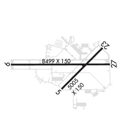
RWY 05/2 3 RWY 08/26 SKED ACR OPS WITH MORE THAN 9 PAX SEATS OR UNSKED ACR WITH AT LEAST 31 PAX SEATS NA.
RWY 08/2 6 RSTRD TO GROUP 1 ACFT UNDER 1500 LBS MTOW, VFR DAYTIME ONLY, NO TGL; PPR - 863-834-4911. SKED ACR OPS WITH MORE THAN 9 PAX SEATS OR UNSKED ACR WITH AT LEAST 31 PAX SEATS NA.
Airport Communications & Frequencies:
ATIS Frequencies:   Hours(local) of Operation: CONTINUOUS
118.025
LAKELAND Tower Frequencies:   Hours(local) of operation: CONTINUOUS   
124.5
236.775
LAKELAND Ground Frequencies:
121.4
Emergency Frequencies:
121.5
Unicom Frequency:
122.950
TAMPA Primary Approach Frequencies:  
120.65
290.3
Part-time Approach Frequencies:  
119.9
TAMPA Primary Departure Frequencies:  
120.65
290.3
Part-time Departure Frequencies:  
119.9
Runway Identifications
Runway Identification: 05/23
Length: 5000 ft
Width: 150 ft
Surface: ASPHALT-FAIR CONDITION
Edge lights: High Intensity

Treatment: GROOVED
Weight: PCN 35 /F/A/X/T

 Runway: 05   Runway: 23
Mag heading: 51°Mag heading: 231°
Rwy Slope: .22% UpRwy Slope: -.22% Down
Approach: Approach:
Pattern: Left TrafficPattern: Left Traffic
Markings: PRECISION INSTRUMENTMarkings: NONPRECISION INSTRUMENT
Marking Condition: GOODMarking Condition: GOOD
Arresting Dev: Arresting Dev:
Lat & Long: N2759.0  W08201.2Lat. & Long.: N2759.6  W08200.6
Elev: 130.2 ft. MSLElev: 141.1 ft. MSL
TCH: 59 ft. AGLTCH: 46 ft. AGL
Visual Glide Path: 3.00 degreesVisual Glide Path: 3.00 degrees
Displaced Threshold: NoDisplaced Threshold: No
Touchdown Zone: YESTouchdown Zone: YES
Touchdown Elev.: 136.0 feetTouchdown Elev.: 141.1 feet
Visual Glide Slope: 4-Light PAPI on LEFT side of RunwayVisual Glide Slope: 4-Light PAPI on LEFT side of Runway
RVR Equipment: RVR Equipment:
RVV Equipment: NORVV Equipment: NO
Approach Lights: Approach Lights:
REIL: NOREIL: NO
Centerline Lights: NOCenterline Lights: NO
Touchdown lights: NOTouchdown lights: NO
Runway Category: DRunway Category: Runway with a Non-precision Approach having visibility minimums greater than 3/4 mile
Declared Distances: TORA:5000' TODA:5000' ASDA:5000' LDA:5000'Declared Distances: TORA:5000' TODA:5000' ASDA:5000' LDA:5000'
Obstructions: Obstructions: TREES
Marked: Marked: NOT Marked/Lighted
Clearance slope: 50:1Clearance slope: 34:1
Obstruction height: Obstruction height: 34 feet AGL
Dist. from runway: Dist. from runway: 1380 feet
Centerline offset: Centerline offset: 125 feet left of centerline
Comments: Comments:
Runway Identification: 08/26
Length: 2208 ft
Width: 60 ft
Surface: GRASS-FAIR CONDITION
Edge lights:

Treatment: NONE

 Runway: 08   Runway: 26
Mag heading: 96°Mag heading: 276°
Rwy Slope: .16% UpRwy Slope: -.16% Down
Approach: Approach:
Pattern: Left TrafficPattern: Left Traffic
Markings: NONSTANDARDMarkings: NONE
Marking Condition: GOOD; RWY 8/26 MKD WITH PAVERS.Marking Condition: GOOD
Arresting Dev: Arresting Dev:
Lat & Long: N2758.8  W08201.5Lat. & Long.: N2758.8  W08201.1
Elev: 127.5 ft. MSLElev: 131.1 ft. MSL
TCH: TCH:
Visual Glide Path: Visual Glide Path:
Displaced Threshold: 362 feetDisplaced Threshold: 556 feet
Touchdown Zone: YESTouchdown Zone: YES
Touchdown Elev.: 132.0 feetTouchdown Elev.: 131.2 feet
Visual Glide Slope: Visual Glide Slope:
RVR Equipment: RVR Equipment:
RVV Equipment: NORVV Equipment: NO
Approach Lights: Approach Lights:
REIL: NOREIL: NO
Centerline Lights: NOCenterline Lights: NO
Touchdown lights: NOTouchdown lights: NO
Runway Category: Runway with a Visual ApproachRunway Category: Runway with a Visual Approach
Declared Distances: TORA:1650' TODA:2010' ASDA:2205' LDA:1845'Declared Distances: TORA:1845' TODA:2205' ASDA:2205' LDA:1650'
Obstructions: TREESObstructions: HANGAR
Marked: NOT Marked/LightedMarked: NOT Marked/Lighted
Clearance slope: 16:1Clearance slope: 11:1
Obstruction height: 51 feet AGLObstruction height: 55 feet AGL
Dist. from runway: 820 feetDist. from runway: 650 feet
Centerline offset: 200 right of centerlineCenterline offset: 145 feet right of centerline
Comments: Comments:
Runway Identification: 10/28
Length: 8500 ft
Width: 150 ft
Surface: ASPHALT
Edge lights: High Intensity

Treatment: GROOVED
Weight: PCN 79 /F/A/X/T

 Runway: 10   Runway: 28
Mag heading: 96°Mag heading: 276°
Rwy Slope: .12% UpRwy Slope: -.12% Down
Approach: ILS/DMEApproach:
Pattern: Left TrafficPattern: Left Traffic
Markings: PRECISION INSTRUMENTMarkings: NONPRECISION INSTRUMENT
Marking Condition: GOODMarking Condition: GOOD
Arresting Dev: Arresting Dev:
Lat & Long: N2759.4  W08202.0Lat. & Long.: N2759.4  W08200.5
Elev: 131.7 ft. MSLElev: 141.8 ft. MSL
TCH: 71 ft. AGLTCH: 71 ft. AGL
Visual Glide Path: 3.00 degreesVisual Glide Path: 3.00 degrees
Displaced Threshold: NoDisplaced Threshold: No
Touchdown Zone: YESTouchdown Zone: YES
Touchdown Elev.: 131.7 feetTouchdown Elev.: 141.8 feet
Visual Glide Slope: 4-Light PAPI on RIGHT side of RunwayVisual Glide Slope: 4-Light PAPI on LEFT side of Runway
RVR Equipment: TOUCHDOWN-MIDFIELD-ROLLOUTRVR Equipment: TOUCHDOWN-MIDFIELD-ROLLOUT
RVV Equipment: NORVV Equipment: NO
Approach Lights: ALSF2 - standard 2,400 foot high intensity approach lighting system with sequenced flashers, Category II or IIIApproach Lights:
REIL: NOREIL: NO
Centerline Lights: YESCenterline Lights: YES
Touchdown lights: YESTouchdown lights: NO
Runway Category: Precision Instrument RunwayRunway Category: D
Declared Distances: TORA:8500' TODA:8500' ASDA:8500' LDA:8500'Declared Distances: TORA:8500' TODA:8500' ASDA:8500' LDA:8500'
Obstructions: Obstructions: TREES
Marked: Marked: NOT Marked/Lighted
Clearance slope: 50:1Clearance slope: 30:1
Obstruction height: Obstruction height: 30 feet AGL
Dist. from runway: Dist. from runway: 1110 feet
Centerline offset: Centerline offset: 455B
Comments: Comments:
C:67/P: