
| ||||||
| ||||||
|
| Rwy | Rwy | |||||||
| 2562x60 | 2562' | 2562x60 | 2562' | |||||
| Runway ID | Single Wheel | Double Wheel | Double Tandem Wheel | Dual Double Wheel |
| 07/25 | 12,000 | N/A | N/A | N/A |
| These numbers are Advisory and are not limits. The Airport Manager should have more accurate Weight Limits | ||||
| FltPlan does not have IFR approach charts available for KL78. |
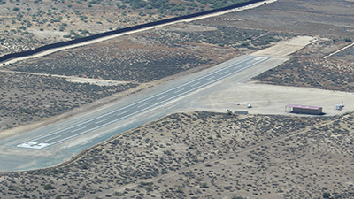
| Facility Name: | JACUMBA |
| City Name: | JACUMBA |
| County: | SAN DIEGO |
| State abbrev: | CA |
| State Name: | CALIFORNIA |
| Ownership: | PUBLICLY OWNED |
| Use: | OPEN TO THE PUBLIC |
| Owner's Name: | COUNTY OF SAN DIEGO |
| Address: | 1960 JOE CROSSON DRIVE |
| EL CAJON, CA 92020-1142 | |
| Owner's Phone: | 619-956-4800 |
| Manager's Name: | MEADOW CHASE; AMGR OFC AT BORREGO VALLEY AIRPORT. |
| Address: | SAN DIEGO COUNTY AIRPORTS, CROSSON DRIVE |
| EL CAJON, CA 92020 | |
| Phone: | 760-788-3366 |
| FAA Region: | WESTERN-PACIFIC |
| FAA Field Office: | LAX |
| Date | Sunrise | Sunset |
|---|---|---|
| 04/26/24 Friday | 6:02 | 19:23 |
| 04/27/24 Saturday | 6:01 | 19:24 |
| 04/28/24 Sunday | 6:00 | 19:25 |
| 04/29/24 Monday | 5:59 | 19:25 |
| 04/30/24 Tuesday | 5:58 | 19:26 |
| 05/01/24 Wednesday | 5:57 | 19:27 |
| 05/02/24 Thursday | 5:56 | 19:28 |
| 05/03/24 Friday | 5:55 | 19:28 |
| 05/04/24 Saturday | 5:54 | 19:29 |
| 05/05/24 Sunday | 5:53 | 19:30 |
| 05/06/24 Monday | 5:52 | 19:30 |
| 05/07/24 Tuesday | 5:52 | 19:31 |
| 05/08/24 Wednesday | 5:51 | 19:32 |
| 05/09/24 Thursday | 5:50 | 19:33 |
| Airport Attendance Schedule | UNATTENDED |
| Airport Status | OPERATIONAL (This Status can change at any time - please check NOTAMS) |
| Airport Lighting Schedule | |
| Airport Storage Available | Tie Downs |
| Extra Services Available | Glider Towing |
| Wind Indicator | YES - (unlit) |
| Control Tower | NO |
| CTAF Frequency | 122.900 |
| Unicom Frequency | |
| Rotating Beacon Color | |
| Segmented Circle | YES |
| Landing Fee | NO |
| Airport Inspected | STATE - performed by STATE AERONAUTICAL PERSONNEL |
| Inspection Date | 02/23/2024 |
| Type of Fuel Available | None |
| Airframe Repair Service | NONE |
| Power Plant Repair Service | NONE |
| Latitude | N3237.0 |
| Longitude | W11609.9 (ESTIMATED) |
| Arpt Elevation | 2844ft (ESTIMATED) |
| Magnetic Variation | 13E |
| 1 miles E | of JACUMBA |
| Traffic Pattern Altitude | |
| Sectional Chart | LOS ANGELES |
| Operations (Reported) | Yearly | Avg. Daily |
|---|---|---|
| General Aviation Transient | 300 | 1 |
| General Aviation Local | 694 | 2 |
| Air Taxi | 0 | 0 |
| Commerical | 0 | 0 |
| Commuter | 0 | 0 |
| Military | 0 | 0 |
| Aircraft based on Field | |
|---|---|
| General Aviation Singles | 0 |
| General Aviation Multi | 0 |
| Jet Aircraft | 0 |
| General Aviation Helicopters | 0 |
| Military Aircraft | 0 |
| Gliders | 2 |
| Ultralights | 0 |
| FSS on field | NO |
| FSS tie-in | SAN DIEGO |
| FSS Phone | 1-800-WX-BRIEF |
| Who issues Notams | SAN |
| Notam D service at airport | YES |
| ARTCC Name | LOS ANGELES |
| Airport Certification | |
| Aircraft Rescue & Firefighting Index | None |
| Airport of Entry | No |
| Custom Landing Rights | No |
| Joint Civil/Military | No |
| Military Landing rights | YES |
| SURPLUS PROPERTY AGREEMENT UNDER PUBLIC LAW 289 |
| ALL ACFT AVOID OVERFLIGHT US/MEXICAN BDR WO AUTH. |
| NOISE ABATEMENT; AVOID OVERFLYING RESIDENTIAL COMMUNITY 1/2 MI W. |
| RCMD RWY TO RAMP TRSN, ASPH TO SOFT DIRT, AT TWY STUB MIDFIELD, ALL OTHER AREAS ASPH TO GRVL. |
| HEL SKID/RUN-ON LDG AND AUTO-ROTATIONS PROHIBITED. |
| RDO EQUIPPPED ACFT SHALL SELF-ANNC ON CTAF PRIOR TO LDG OR TKOF. |
| PN TO OBTAIN VEHICLE ACES TO AP, CALL 619-956-4800. |
| PPR ALL MIL ACFT CTC AMGR. |
| FOR CD CTC LOS ANGELES ARTCC AT 661-575-2079. |
| WIND PMTG, RCMD LAND RWY 07 AND DEPART RWY 25 DUE TO 480 FT HILL 1 MI E OF AP. |
| FRQ GLD ACT DRG WKENDS, PWRD ACFT BE ALERT FOR GLD TFC LAUNCHING FRM FLD AND OPERG ON AND IN VCNTY OF AP, SFC TO 18000 FT MSL. |
| RAPIDLY RISING TRRN ALL QUADS. |
| OCNL WILDLIFE ON AND IN VCNTY OF AP. |
| CONTIGUOUS ADIZ IN VCNTY AND ALONG INTL BDRY, LCTD APRXLY 615 FT S OF RWY 07-25. |
| RWY 07/2 5 CLSD SS-SR, NOT LGTD. |
| Runway: 07 | Runway: 25 | ||
| Mag heading: | N/A | Mag heading: | N/A |
| Approach: | Approach: | ||
| Pattern: | Left Traffic | Pattern: | Right Traffic; INTL BDRY TO S. |
| Markings: | BASIC | Markings: | BASIC |
| Marking Condition: | GOOD | Marking Condition: | GOOD |
| Arresting Dev: | Arresting Dev: | ||
| Lat & Long: | N3236.9 W11610.2 | Lat. & Long.: | N3237.0 W11609.7 |
| Elev: | N/A | Elev: | N/A |
| TCH: | TCH: | ||
| Visual Glide Path: | Visual Glide Path: | ||
| Displaced Threshold: | No | Displaced Threshold: | No |
| Touchdown Zone: | NO | Touchdown Zone: | NO |
| Touchdown Elev.: | Touchdown Elev.: | ||
| Visual Glide Slope: | Visual Glide Slope: | ||
| RVR Equipment: | RVR Equipment: | ||
| RVV Equipment: | NO | RVV Equipment: | NO |
| Approach Lights: | Approach Lights: | ||
| REIL: | NO | REIL: | NO |
| Centerline Lights: | NO | Centerline Lights: | NO |
| Touchdown lights: | NO | Touchdown lights: | NO |
| Runway Category: | Runway with a Visual Approach | Runway Category: | Runway with a Visual Approach |
| Declared Distances: | Declared Distances: | ||
| Obstructions: | Obstructions: | HILL | |
| Marked: | Marked: | NOT Marked/Lighted | |
| Clearance slope: | 50:1 | Clearance slope: | 10:1 |
| Obstruction height: | Obstruction height: | 480 feet AGL | |
| Dist. from runway: | Dist. from runway: | 5000 feet | |
| Centerline offset: | Centerline offset: | ||
| Comments: | Comments: |