Click here for more info on on SMS!

KL70

AGUA DULCE
AGUA DULCE
CA
Time Zone: Pacific
Lat: N 3430.2
Long: W 11818.8
Elev: 2633
Var: -14
Longest Runway: 4205
CTAF: 122.8

FBO & Flight Services info for KL70

FBOs: Update your Fuel Prices

AGUA DULCE ARPTPh: 661-268-8835 Fax: 661-268-7662 Freq: 122.9
Service
Jet
100LL
SAF
MoGas
Full        Last Update: 04/20/2024 17:14

Self  7.06    
 Address: 33638 AGUA DULCE CANYON RD   AGUA DULCE, CA 91390
If you are an FBO, call 1-203-262-1700 to update your info or email: FltPlan.Advertising@garmin.com
Advertise your FBO on FltPlan.com

Runway & Approach Info for KL70
Rwy
Length
Land Dist**
Approach*
  Rwy
Length
Land Dist**
Approach*
04
4205x50  4025'          
 
  
22
  4205x50  3873'          
 
 * only ILS, LOC, LDA, and SDF approaches to a specific runway are shown
** For any Declared Landing Distance Available, please see A/FD or Approach plates
Runway Weight Capability (lbs.) Help
Runway IDSingle WheelDouble WheelDouble Tandem WheelDual Double Wheel
04/22N/AN/AN/AN/A
These numbers are Advisory and are not limits.   The Airport Manager should have more accurate Weight Limits
Approach Charts
FltPlan does not have IFR approach charts available for KL70.
Current Weather/Notams
Customs Information Send updates to Support@FltPlan.com
Customs Not Available
Database effective 05/16/2024
Airport Diagram of KL70
Airport Diagram might not be current.

Facility Name: AGUA DULCE
City Name: AGUA DULCE
County: LOS ANGELES
State abbrev: CA
State Name: CALIFORNIA
   
Ownership: PRIVATELY OWNED
Use: OPEN TO THE PUBLIC
Owner's Name: LAND SEA AIR LEASING CORPORATION
Address: 15853 OLDEN STREET, P.O. BOX 9203
 SYLMAR, CA 91392
Owner's Phone: (661) 268-8835
  
Manager's Name: JON BONNER; DOUG ABNEY, ASST ARPT OPNS - PHONE 661-268-8835 CELL 661-268-8835. EMAIL: SUPPORT@L70AIRPORT.COM
Address: 33638 AGUA DULCE CANYON ROAD, P. O. BOX 9203
 AGUA DULCE, CA 91390
Phone: (661) 268-8835
   
FAA Region: WESTERN-PACIFIC
FAA Field Office: LAX


Sunrise / Sunset times for AGUA DULCE

DateSunriseSunset
04/23/24 Tuesday6:1119:32
04/24/24 Wednesday6:1019:33
04/25/24 Thursday6:0919:34
04/26/24 Friday6:0819:35
04/27/24 Saturday6:0719:35
04/28/24 Sunday6:0619:36
04/29/24 Monday6:0419:37
04/30/24 Tuesday6:0319:38
05/01/24 Wednesday6:0219:39
05/02/24 Thursday6:0119:39
05/03/24 Friday6:0019:40
05/04/24 Saturday5:5919:41
05/05/24 Sunday5:5819:42
05/06/24 Monday5:5819:43

Airport Facilities

Airport Attendance Schedule7 Days A Week 0800-1800; AIRPORT UNATNDD CHRISTMAS DAY; THANKSGIVING DAY AND NEW YEARS DAY.
Airport Status OPERATIONAL (This Status can change at any time - please check NOTAMS)
Airport Lighting Schedule
Airport Storage AvailableTie Downs
Extra Services AvailableNONE
Wind IndicatorYES - (unlit)
Control TowerNO
CTAF Frequency122.800
Unicom Frequency122.800
Rotating Beacon Color
Segmented CircleYES
Landing FeeNO

Airport Inspection Data

Airport InspectedSTATE - performed by STATE AERONAUTICAL PERSONNEL
Inspection Date01/12/2022

Airport Services

Type of Fuel AvailableGrade 100LL; -10SELF SERVICE
Airframe Repair ServiceNONE
Power Plant Repair ServiceNONE

Geographic Data

LatitudeN3430.2
LongitudeW11818.8 (ESTIMATED)
Arpt Elevation2633ft (ESTIMATED)
Magnetic Variation14E
2 miles Eof AGUA DULCE
Traffic Pattern Altitude
Sectional ChartLOS ANGELES

Aircraft Data

Operations (Reported)YearlyAvg. Daily
General Aviation Transient 3601
General Aviation Local 3601
Air Taxi 00
Commerical 00
Commuter 00
Military 00
Aircraft based on Field
General Aviation Singles 27
General Aviation Multi 2
Jet Aircraft 0
General Aviation Helicopters 3
Military Aircraft 0
Gliders 1
Ultralights 0

FAA Services

FSS on field NO
FSS tie-in RIVERSIDE
FSS Phone 1-800-WX-BRIEF
Who issues Notams RAL
Notam D service at airport YES
ARTCC Name LOS ANGELES

Federal Status

Airport Certification
Aircraft Rescue & Firefighting IndexNone
Airport of EntryNo
Custom Landing RightsNo
Joint Civil/MilitaryNo
Military Landing rightsNo

Remarks

RIDGE SOUTH OF AIRPORT PARALLEL TO RY VIOLATES 7:1 TRANSITIONAL SURFACE.
FORMATION ARRIVALS AND DEPARTURES PROHIBITED.
NO AEROBATICS PERMITTED.
AIRPORT CLSD SUNSET TO SUNRISE. ALL NIGHT OPERATIONS PROHIBITED BY LOCAL RESTRICTIONS.
ACTVT MIKE 5 TIMES ON CTAF FREQ FOR ARPT WX.
FOR CD CTC JOSHUA APCH AT 661-277-3843.
10-25 FT WIDE DITCH AT 170 FT ALONG SE EDGE OF RY.
TGL NOT PERMITTED.
AVOID FLYING WITHIN 1000 FT OF SCHOOL APRXLY ONE MILE SOUTHWEST. RY 04 DEP AVOID FLYING OVER HOMES 2,000 FT NE OF RY END.
Runway Identifications
Runway Identification: 04/22
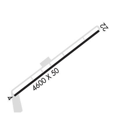
Length: 4205 ft
Width: 50 ft
Surface: ASPHALT-GOOD CONDITION
Edge lights:

Treatment: NONE

 Runway: 04   Runway: 22
Mag heading: N/AMag heading: N/A
Rwy Slope: 1.83% UpRwy Slope: -1.83% Down
Approach: Approach:
Pattern: Left TrafficPattern: Right Traffic
Markings: BASICMarkings: BASIC
Marking Condition: GOODMarking Condition: GOOD
Arresting Dev: Arresting Dev:
Lat & Long: N3430.0  W11819.1Lat. & Long.: N3430.4  W11818.5
Elev: 2556.0 ft. MSLElev: 2633.0 ft. MSL
TCH: TCH:
Visual Glide Path: Visual Glide Path:
Displaced Threshold: 180 feetDisplaced Threshold: 332 feet
Touchdown Zone: YESTouchdown Zone: YES
Touchdown Elev.: 2610.9 feetTouchdown Elev.: 2626.5 feet
Visual Glide Slope: Visual Glide Slope:
RVR Equipment: RVR Equipment:
RVV Equipment: NORVV Equipment: NO
Approach Lights: Approach Lights:
REIL: NOREIL: NO
Centerline Lights: NOCenterline Lights: NO
Touchdown lights: NOTouchdown lights: NO
Runway Category: Runway with a Visual ApproachRunway Category: Runway with a Visual Approach
Declared Distances: Declared Distances:
Obstructions: BLDGObstructions: FENCE
Marked: NOT Marked/LightedMarked: NOT Marked/Lighted
Clearance slope: 2:1; RWY 04 APCH RATIO TO DSPLCD THLD 20:1 (DSPLCD THLD IS 5 FT HIGHER THAN EOR); APCH RATIO TO DSPLCD THLD OVER +15 FT HILL 300 FT FM DSPLCD THLD 150 FT RIGHTR 20:1.Clearance slope: APCH RATIO TO DSPLCD THR 50:1; APCH RATIO TO DSPLCD THR OVER +300 FT HILL 4700 FT FROM DSPLCD THR 0FT LEFT AND RIGHT 15:1.
Obstruction height: 15 feet AGLObstruction height: 4 feet AGL
Dist. from runway: 240 feetDist. from runway: 200 feet
Centerline offset: 85 right of centerlineCenterline offset: 35 feet right of centerline
Comments: RWY 04 +15 FT HANGER 140-160 FT FM EOR 80 FT RIGHT.Comments: +4 FT FENCE 0 FT - 200 FT FROM EOR DIAGONALLY FROM 50 FT LEFT TO 35 FT RIGHT.
C:/P: