
| ||||||||||||||||||||||||||||||||
| ||||||||||||||||||||||||||||||||
| Rwy | Rwy | |||||||
| 2500x60 | 2500' | 2500x60 | 2500' | |||||
| Runway ID | Single Wheel | Double Wheel | Double Tandem Wheel | Dual Double Wheel |
| 11/29 | 12,000 | N/A | N/A | N/A |
| These numbers are Advisory and are not limits. The Airport Manager should have more accurate Weight Limits | ||||
| FltPlan does not have IFR approach charts available for KL54. |
| Facility Name: | AGUA CALIENTE SPRINGS |
| City Name: | AGUA CALIENTE SPRINGS |
| County: | SAN DIEGO |
| State abbrev: | CA |
| State Name: | CALIFORNIA |
| Ownership: | PUBLICLY OWNED |
| Use: | OPEN TO THE PUBLIC |
| Owner's Name: | COUNTY OF SAN DIEGO |
| Address: | 1960 JOE CROSSON DRIVE |
| EL CAJON, CA 92020-1142 | |
| Owner's Phone: | 619-956-4800 |
| Manager's Name: | MEADOW CHASE; AMGR OFC AT BORREGO VALLEY AIRPORT. |
| Address: | SAN DIEGO COUNTY AIRPORTS, 1960 JOE CROSSON DRIVE |
| EL CAJON, CA 92020 | |
| Phone: | 760-767-7415 |
| FAA Region: | WESTERN-PACIFIC |
| FAA Field Office: | LAX |
| Date | Sunrise | Sunset |
|---|---|---|
| 04/17/24 Wednesday | 6:12 | 19:18 |
| 04/18/24 Thursday | 6:11 | 19:18 |
| 04/19/24 Friday | 6:10 | 19:19 |
| 04/20/24 Saturday | 6:09 | 19:20 |
| 04/21/24 Sunday | 6:07 | 19:21 |
| 04/22/24 Monday | 6:06 | 19:21 |
| 04/23/24 Tuesday | 6:05 | 19:22 |
| 04/24/24 Wednesday | 6:04 | 19:23 |
| 04/25/24 Thursday | 6:03 | 19:23 |
| 04/26/24 Friday | 6:02 | 19:24 |
| 04/27/24 Saturday | 6:01 | 19:25 |
| 04/28/24 Sunday | 6:00 | 19:26 |
| 04/29/24 Monday | 5:59 | 19:26 |
| 04/30/24 Tuesday | 5:58 | 19:27 |
| Airport Attendance Schedule | UNATTENDED |
| Airport Status | OPERATIONAL (This Status can change at any time - please check NOTAMS) |
| Airport Lighting Schedule | |
| Airport Storage Available | Tie Downs |
| Extra Services Available | NONE |
| Wind Indicator | YES - (unlit) |
| Control Tower | NO |
| CTAF Frequency | 122.900 |
| Unicom Frequency | |
| Rotating Beacon Color | |
| Segmented Circle | YES |
| Landing Fee | NO |
| Airport Inspected | STATE - performed by STATE AERONAUTICAL PERSONNEL |
| Inspection Date | 06/08/2021 |
| Type of Fuel Available | None |
| Airframe Repair Service | NONE |
| Power Plant Repair Service | NONE |
| Latitude | N3257.3 |
| Longitude | W11617.7 (ESTIMATED) |
| Arpt Elevation | 1220ft (ESTIMATED) |
| Magnetic Variation | 13E |
| 1 miles NE | of AGUA CALIENTE SPRINGS |
| Traffic Pattern Altitude | 800 |
| Sectional Chart | LOS ANGELES |
| Operations (Reported) | Yearly | Avg. Daily |
|---|---|---|
| General Aviation Transient | 3300 | 9 |
| General Aviation Local | 0 | 0 |
| Air Taxi | 0 | 0 |
| Commerical | 0 | 0 |
| Commuter | 0 | 0 |
| Military | 55 | 0 |
| Aircraft based on Field | |
|---|---|
| General Aviation Singles | 0 |
| General Aviation Multi | 0 |
| Jet Aircraft | 0 |
| General Aviation Helicopters | 0 |
| Military Aircraft | 0 |
| Gliders | 0 |
| Ultralights | 0 |
| FSS on field | NO |
| FSS tie-in | SAN DIEGO |
| FSS Phone | 1-800-WX-BRIEF |
| Who issues Notams | SAN |
| Notam D service at airport | YES |
| ARTCC Name | LOS ANGELES |
| Airport Certification | |
| Aircraft Rescue & Firefighting Index | None |
| Airport of Entry | No |
| Custom Landing Rights | No |
| Joint Civil/Military | No |
| Military Landing rights | No |
| HAZARDOUS DURING RAINS OR FLASH FLOODS. |
| OBSTRN PART 77-MTNS S & W OF RWY, DIRT BERM, DITCH, SAND BOTH SIDES OF RWY. |
| ACFT TIED DOWN WITHIN PRIMARY SFC. |
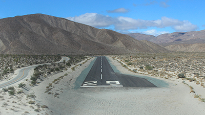
| WIND PERMITTING USE OF RY 29 FOR LANDING AND RY 11 FOR DEPARTURE RECOMMENDED DUE TO 460 FT HILL 1/2 MILE WEST OF AIRPORT |
| ACFT SHALL SELF ANNC ON CTAF PRIOR TO LDG OR DEP. |
| PPR FOR ALL MIL ACFT, COPTER SKID/RUN-ON LDG PROHIBITED; CTC AMGR. |
| FOR CD CTC LOS ANGELES ARTCC AT 661-575-2079. |
| RWY 11/29 CLSD SS-SR; NOT LIGHTED. |
| RWY 11/2 9 CLSD SS-SR; NOT LGTD. |
| Runway: 11 | Runway: 29 | ||
| Mag heading: | 105° | Mag heading: | 285° |
| Approach: | Approach: | ||
| Pattern: | Left Traffic | Pattern: | Right Traffic; HILL 0.5 MI W OF AP. |
| Markings: | BASIC | Markings: | BASIC |
| Marking Condition: | GOOD | Marking Condition: | GOOD |
| Arresting Dev: | Arresting Dev: | ||
| Lat & Long: | N3257.4 W11617.9 | Lat. & Long.: | N3257.2 W11617.5 |
| Elev: | N/A | Elev: | N/A |
| TCH: | TCH: | ||
| Visual Glide Path: | Visual Glide Path: | ||
| Displaced Threshold: | No | Displaced Threshold: | No |
| Touchdown Zone: | NO | Touchdown Zone: | NO |
| Touchdown Elev.: | Touchdown Elev.: | ||
| Visual Glide Slope: | Visual Glide Slope: | ||
| RVR Equipment: | RVR Equipment: | ||
| RVV Equipment: | NO | RVV Equipment: | NO |
| Approach Lights: | Approach Lights: | ||
| REIL: | NO | REIL: | NO |
| Centerline Lights: | NO | Centerline Lights: | NO |
| Touchdown lights: | NO | Touchdown lights: | NO |
| Runway Category: | Runway with a Visual Approach | Runway Category: | Runway with a Visual Approach |
| Declared Distances: | Declared Distances: | ||
| Obstructions: | HILL | Obstructions: | |
| Marked: | NOT Marked/Lighted | Marked: | |
| Clearance slope: | 5:1 | Clearance slope: | 50:1 |
| Obstruction height: | 460 feet AGL | Obstruction height: | |
| Dist. from runway: | 2500 feet | Dist. from runway: | |
| Centerline offset: | Centerline offset: | ||
| Comments: | Comments: |