Click here for more info on on SMS!

KL47

OLLA (CLOSED)
OLLA
LA
Time Zone: Central
Lat: N 3153.8
Long: W 09213.1
Elev: 130
Var: -04
Longest Runway: 3010
CTAF: 122.9

FBO & Flight Services info for KL47

FBOs: Update your Fuel Prices

AIRPORT - CLOSEDPh: 318-992-2101
-
Freq: 122.9
If you are an FBO, call 1-203-262-1700 to update your info or email: FltPlan.Advertising@garmin.com
Advertise your FBO on FltPlan.com

Runway & Approach Info for KL47
Rwy
Length
Land Dist**
Approach*
  Rwy
Length
Land Dist**
Approach*
03
3010x75  3010'          
 
  
21
  3010x75  2820'          
 
 * only ILS, LOC, LDA, and SDF approaches to a specific runway are shown
** For any Declared Landing Distance Available, please see A/FD or Approach plates
Runway Weight Capability (lbs.) Help
Runway IDSingle WheelDouble WheelDouble Tandem WheelDual Double Wheel
03/219,000N/AN/AN/A
These numbers are Advisory and are not limits.   The Airport Manager should have more accurate Weight Limits
Approach Charts
FltPlan does not have IFR approach charts available for KL47.
Current Weather/Notams
Customs Information Send updates to Support@FltPlan.com
Customs Not Available
A/FD
No A/FD Information
Database effective 06/16/2022
Airport Diagram of KL47
Airport Diagram might not be current.

Facility Name: OLLA
City Name: OLLA
County: LA SALLE
State abbrev: LA
State Name: LOUISIANA
   
Ownership: PUBLICLY OWNED
Use: OPEN TO THE PUBLIC
Owner's Name: OLLA URANIA TULLOS STANDARD; ECONOMIC DEVELOPMENT DISTRICT
Address: PO BOX 223
 OLLA, LA 71465
Owner's Phone: 318-312-1106
  
Manager's Name: JEFREY LASITER
Address: 4253 HWY 124EE
 OLLA, LA 71465
Phone: (318) 312-1106
   
FAA Region: SOUTHWEST
FAA Field Office: LNM


Sunrise / Sunset times for OLLA

DateSunriseSunset
04/24/24 Wednesday6:2919:45
04/25/24 Thursday6:2819:46
04/26/24 Friday6:2719:46
04/27/24 Saturday6:2619:47
04/28/24 Sunday6:2519:48
04/29/24 Monday6:2419:48
04/30/24 Tuesday6:2319:49
05/01/24 Wednesday6:2219:50
05/02/24 Thursday6:2119:51
05/03/24 Friday6:2119:51
05/04/24 Saturday6:2019:52
05/05/24 Sunday6:1919:53
05/06/24 Monday6:1819:53
05/07/24 Tuesday6:1719:54

Airport Facilities

Airport Attendance ScheduleUNATTENDED
Airport StatusCLOSED PERMANENTLY (This Status can change at any time - please check NOTAMS)
Airport Lighting ScheduleARPT BCN OTS.
Airport Storage AvailableNONE
Extra Services AvailableNONE
Wind IndicatorNONE
Control TowerNO
CTAF Frequency122.900
Unicom Frequency
Rotating Beacon ColorCLEAR-GREEN (Light Land Airport); ROTG BCN OTS INDEFLY.
Segmented CircleNO
Landing FeeNO

Airport Inspection Data

Airport InspectedSTATE - performed by STATE AERONAUTICAL PERSONNEL
Inspection Date02/12/2020

Airport Services

Type of Fuel AvailableNone
Airframe Repair ServiceNONE
Power Plant Repair ServiceNONE

Geographic Data

LatitudeN3153.8
LongitudeW09213.1 (ESTIMATED)
Arpt Elevation130ft (ESTIMATED)
Magnetic Variation04E
1 miles Eof OLLA
Traffic Pattern Altitude
Sectional ChartHOUSTON

Aircraft Data

Operations (Reported)YearlyAvg. Daily
General Aviation Transient 12003
General Aviation Local 25007
Air Taxi 00
Commerical 00
Commuter 00
Military 00
Aircraft based on Field
General Aviation Singles 1
General Aviation Multi 0
Jet Aircraft 0
General Aviation Helicopters 0
Military Aircraft 0
Gliders 0
Ultralights 0

FAA Services

FSS on field NO
FSS tie-in DE RIDDER
FSS Phone 1-800-WX-BRIEF
Who issues Notams DRI
Notam D service at airport YES
ARTCC Name HOUSTON

Federal Status

Airport Certification
Aircraft Rescue & Firefighting IndexNone
Airport of EntryNo
Custom Landing RightsNo
Joint Civil/MilitaryNo
Military Landing rightsNo

Remarks

APRON COND POOR.
PONDING ON RY & TWYS DURG HEAVY RAINS.
RY 03/21 75 FT TREES ALONG BOTH SIDES OF RY PENETRATE TRANSITION SLOPE.
AIRPORT CLOSED PERMANENTLY
RY 03 HAS A DIP 450 FT FM APCH END OF RY.
FOR CD CTC POLK APCH AT 337-531-2352.
(ARPT STATUS) ARPT CLSD PERMLY.
RWY 03/2 1 RY SFC CRACKED; DIP IN RY NEAR RY 03 END. 1-2 FT GRASS GROWING ON RY.
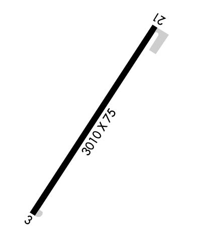
Runway Identifications
Runway Identification: 03/21
Length: 3010 ft
Width: 75 ft
Surface: ASPHALT-POOR CONDITION
Edge lights:

 Runway: 03   Runway: 21
Mag heading: N/AMag heading: N/A
Approach: Approach:
Pattern: Left TrafficPattern: Left Traffic
Markings: BASICMarkings: BASIC
Marking Condition: POOR; RWY MARKINGS ARE FADED, CRACKED AND DETERIORATED.Marking Condition: POOR; DSPLCD THLD MARKINGS NON-STANDARD; NO CHEVRONS, ARROWS OR THLD BAR.
Arresting Dev: Arresting Dev:
Lat & Long: N3153.6  W09213.2Lat. & Long.: N3154.0  W09212.9
Elev: N/AElev: N/A
TCH: TCH:
Visual Glide Path: Visual Glide Path:
Displaced Threshold: NoDisplaced Threshold: 190 feet
Touchdown Zone: NOTouchdown Zone: NO
Touchdown Elev.: Touchdown Elev.:
Visual Glide Slope: Visual Glide Slope:
RVR Equipment: RVR Equipment:
RVV Equipment: NORVV Equipment: NO
Approach Lights: Approach Lights:
REIL: NOREIL: NO
Centerline Lights: NOCenterline Lights: NO
Touchdown lights: NOTouchdown lights: NO
Runway Category: Runway with a Visual ApproachRunway Category: Runway with a Visual Approach
Declared Distances: Declared Distances:
Obstructions: TREESObstructions: ROAD
Marked: NOT Marked/LightedMarked: MARKED
Clearance slope: 11:1Clearance slope: 1:1; APCH SLOPE TO DSPLD THLD 11:1. 76 FT TREES 303 FT LEFT OF CNTLN.
Obstruction height: 50 feet AGLObstruction height: 15 feet AGL
Dist. from runway: 775 feetDist. from runway: 215 feet
Centerline offset: 147 left of centerlineCenterline offset:
Comments: Comments:
C:/P: