
| ||||||||||||||||||||||||||||||||||||||||||||
| ||||||||||||||||||||||||||||||||||||||||||||
| ||||||||||||||||||||||||||||||||||||||||||||
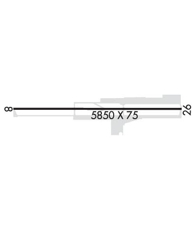
| Rwy | Rwy | |||||||
| 5850x75 | 5480' | 5850x75 | 5250' | |||||
| Runway ID | Single Wheel | Double Wheel | Double Tandem Wheel | Dual Double Wheel |
| 08/26 | 12,500 | N/A | N/A | N/A |
| These numbers are Advisory and are not limits. The Airport Manager should have more accurate Weight Limits | ||||
 Airport Diagram might not be current. | |
| Facility Name: | BIG BEAR CITY |
| City Name: | BIG BEAR CITY |
| County: | SAN BERNARDINO |
| State abbrev: | CA |
| State Name: | CALIFORNIA |
| Ownership: | PUBLICLY OWNED |
| Use: | OPEN TO THE PUBLIC |
| Owner's Name: | BIG BEAR AIRPORT DIST |
| Address: | P O BOX 755 |
| BIG BEAR CITY, CA 92314-0755 | |
| Owner's Phone: | 909-585-3219 |
| Manager's Name: | RYAN GOSS |
| Address: | PO BOX 755 |
| BIG BEAR CITY, CA 92314-0755 | |
| Phone: | 909-585-3219 |
| FAA Region: | WESTERN-PACIFIC |
| FAA Field Office: | LAX |

| Date | Sunrise | Sunset |
|---|---|---|
| 04/18/24 Thursday | 6:12 | 19:22 |
| 04/19/24 Friday | 6:10 | 19:23 |
| 04/20/24 Saturday | 6:09 | 19:24 |
| 04/21/24 Sunday | 6:08 | 19:24 |
| 04/22/24 Monday | 6:07 | 19:25 |
| 04/23/24 Tuesday | 6:06 | 19:26 |
| 04/24/24 Wednesday | 6:04 | 19:27 |
| 04/25/24 Thursday | 6:03 | 19:28 |
| 04/26/24 Friday | 6:02 | 19:28 |
| 04/27/24 Saturday | 6:01 | 19:29 |
| 04/28/24 Sunday | 6:00 | 19:30 |
| 04/29/24 Monday | 5:59 | 19:31 |
| 04/30/24 Tuesday | 5:58 | 19:32 |
| 05/01/24 Wednesday | 5:57 | 19:32 |
| Airport Attendance Schedule | 7 Days A Week 0800-1700 |
| Airport Status | OPERATIONAL (This Status can change at any time - please check NOTAMS) |
| Airport Lighting Schedule | ACTVT MIRL RY 08/26 - CTAF. PAPI RYS 08 & 26 OPER CONT. |
| Airport Storage Available | Tie Downs, Hanger |
| Extra Services Available | Air Ambulance, Charter |
| Wind Indicator | YES - (lighted) |
| Control Tower | NO |
| CTAF Frequency | 122.725 |
| Unicom Frequency | 122.725 |
| Rotating Beacon Color | WG |
| Segmented Circle | YES |
| Landing Fee | NO |
| Airport Inspected | STATE - performed by STATE AERONAUTICAL PERSONNEL |
| Inspection Date | 06/06/2023 |
| Type of Fuel Available | Grade 100LL, JET A (freeze point -40C); -A JET A FUEL AVBL 0800-1600 LCL, SELF-SERVICE AFTER HOURS.; -10100LL AVBL 24 HOUR SELF SERVICE. |
| Airframe Repair Service | MINOR |
| Power Plant Repair Service | MINOR |
| Latitude | N3415.8 |
| Longitude | W11651.4 (ESTIMATED) |
| Arpt Elevation | 6752ft (SURVEYED) |
| Magnetic Variation | 14E |
| 0 miles W | of BIG BEAR CITY |
| Traffic Pattern Altitude | 1200 |
| Sectional Chart | LOS ANGELES |
| Operations (Reported) | Yearly | Avg. Daily |
|---|---|---|
| General Aviation Transient | 16800 | 46 |
| General Aviation Local | 11200 | 31 |
| Air Taxi | 0 | 0 |
| Commerical | 0 | 0 |
| Commuter | 0 | 0 |
| Military | 2000 | 5 |
| Aircraft based on Field | |
|---|---|
| General Aviation Singles | 53 |
| General Aviation Multi | 3 |
| Jet Aircraft | 1 |
| General Aviation Helicopters | 3 |
| Military Aircraft | 0 |
| Gliders | 1 |
| Ultralights | 0 |
| FSS on field | NO |
| FSS tie-in | RIVERSIDE |
| FSS Phone | 1-800-WX-BRIEF |
| Who issues Notams | RAL |
| Notam D service at airport | YES |
| ARTCC Name | LOS ANGELES |
| Airport Certification | |
| Aircraft Rescue & Firefighting Index | None |
| Airport of Entry | No |
| Custom Landing Rights | No |
| Joint Civil/Military | No |
| Military Landing rights | YES |
| NATIONAL PLAN OF INTEGRATED AIRPORT SYSTEMS (NPIAS) |
| GRANT AGREEMENTS UNDER FAAP/ADAP/AIP |
| ASSURANCES PURSUANT TO TITLE VI, CIVIL RIGHTS ACT OF 1964 |
| THIS AIRPORT HAS BEEN SURVEYED BY THE NATIONAL GEODETIC SURVEY. |
| MOUNTAINS ALL QUADRANTS; PEAK HAZARD LGTS SE; S; & NW. |
| NOISE ABATEMENT PROCEDURES; AVOID OVERFLYING OF HIGH SCHOOL 1 MILE EAST AT ALL TIMES. |
| ON TKOF MAKE 10 DEG LEFT TURN AT END OF RY TO AVOID HOUSING TO EAST AND ELEMENTARY SCHOOL TO WEST OF ARPT. |
| FOR CD CTC LOS ANGELES ARTCC AT 661-575-2079. |
Airport Communications & Frequencies:
| |||||||||
| Runway: 08 | Runway: 26 | ||
| Mag heading: | 76° | Mag heading: | 256° |
| Rwy Slope: | .02% Up | Rwy Slope: | -.02% Down |
| Approach: | Approach: | ||
| Pattern: | Right Traffic | Pattern: | Left Traffic |
| Markings: | NONPRECISION INSTRUMENT | Markings: | NONPRECISION INSTRUMENT |
| Marking Condition: | GOOD | Marking Condition: | GOOD |
| Arresting Dev: | Arresting Dev: | ||
| Lat & Long: | N3415.8 W11651.9 | Lat. & Long.: | N3415.8 W11650.8 |
| Elev: | 6750.1 ft. MSL | Elev: | 6751.4 ft. MSL |
| TCH: | 29 ft. AGL | TCH: | 46 ft. AGL |
| Visual Glide Path: | 4.30 degrees | Visual Glide Path: | 4.30 degrees |
| Displaced Threshold: | 370 feet | Displaced Threshold: | 600 feet |
| Touchdown Zone: | YES | Touchdown Zone: | YES |
| Touchdown Elev.: | 6752.0 feet | Touchdown Elev.: | 6752.4 feet |
| Visual Glide Slope: | 2-Light PAPI on LEFT side of Runway | Visual Glide Slope: | 2-Light PAPI on LEFT side of Runway |
| RVR Equipment: | RVR Equipment: | ||
| RVV Equipment: | NO | RVV Equipment: | NO |
| Approach Lights: | Approach Lights: | ||
| REIL: | NO | REIL: | NO |
| Centerline Lights: | NO | Centerline Lights: | NO |
| Touchdown lights: | NO | Touchdown lights: | NO |
| Runway Category: | Runway with a Visual Approach | Runway Category: | Runway with a Non-precision Approach |
| Declared Distances: | Declared Distances: | ||
| Obstructions: | Obstructions: | TREES | |
| Marked: | Marked: | NOT Marked/Lighted | |
| Clearance slope: | 20:1; APCH RATIO TO DSPLCD THR OVER +15' ROAD 480' FM DSPLCD THR 32:1 | Clearance slope: | 20:1; RWY 26 APCH RATIO TO DSPLCD THR 20:1; APCH RATIO TO DSPLCD THR OVER +50 FT TREES 1000 FT FM DSPLCD THR 100 FT LEFT 20:1. |
| Obstruction height: | Obstruction height: | 40 feet AGL | |
| Dist. from runway: | Dist. from runway: | 1000 feet | |
| Centerline offset: | Centerline offset: | 100 feet left of centerline | |
| Comments: | ROAD & 6' FENCE 110' FM THR PERPENDICULAR TO CNTRLN. | Comments: | ROAD & 6' FENCE 100' FM THR 125' RIGHT. |