Approach Charts
| FltPlan does not have IFR approach charts available for KL32. |
Current Weather/Notams (Metars, TAFs, Notams, NWS Forecast, PIREPS, and nearby weather)
Customs Information Send updates to Support@FltPlan.com
Customs Not Available
Database effective 04/18/2024
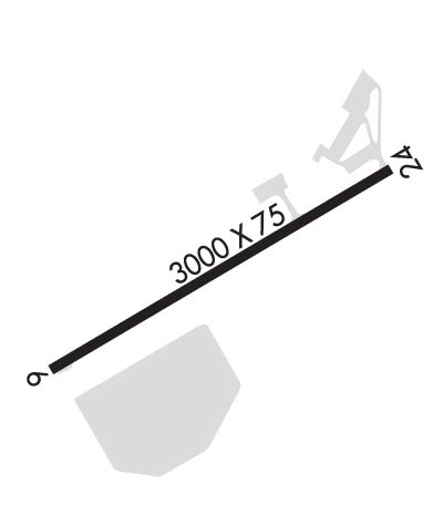
Airport Diagram might not be current.
|
| Facility Name: | JONESVILLE |
| City Name: | JONESVILLE |
| County: | CATAHOULA |
| State abbrev: | LA |
| State Name: | LOUISIANA |
| | |
| Ownership: | PUBLICLY OWNED |
| Use: | OPEN TO THE PUBLIC |
| Owner's Name: | TOWN OF JONESVILLE |
| Address: | BOX 428 |
| | JONESVILLE, LA 71343 |
| Owner's Phone: | 318-339-8596 |
| | |
| Manager's Name: | PAT MC CAUGHEY |
| Address: | 503 AIRPORT ROAD, PO BOX 116 |
| | JONESVILLE, LA 71343 |
| Phone: | 318-339-4747; OR 318-339-8298. |
| | |
| FAA Region: | SOUTHWEST |
| FAA Field Office: | LNM |
Runway Identifications
Runway Identification: 06/24Length: 3000 ft
Width: 75 ft
Surface: ASPHALT-GOOD CONDITION
Edge lights: Medium IntensityTreatment: NONE
| | Runway: 06 | | Runway: 24 |
| Mag heading: | N/A | Mag heading: | N/A |
| Rwy Slope: | .05% Up | Rwy Slope: | -.05% Down |
| Approach: | | Approach: | |
| Pattern: | Left Traffic | Pattern: | Left Traffic |
| Markings: | NONPRECISION INSTRUMENT | Markings: | NONPRECISION INSTRUMENT |
| Marking Condition: | FAIR | Marking Condition: | FAIR |
| Arresting Dev: | | Arresting Dev: | |
| Lat & Long: | N3137.1 W09150.3 | Lat. & Long.: | N3137.3 W09149.8 |
| Elev: | 54.1 ft. MSL | Elev: | 55.7 ft. MSL |
| TCH: | 66 ft. AGL | TCH: | 68 ft. AGL |
| Visual Glide Path: | 4.00 degrees | Visual Glide Path: | 4.00 degrees |
| Displaced Threshold: | No | Displaced Threshold: | No |
| Touchdown Zone: | NO | Touchdown Zone: | NO |
| Touchdown Elev.: | | Touchdown Elev.: | |
| Visual Glide Slope: | 2-Light PAPI on LEFT side of Runway; PAPI OBSTRUCTED BY TREES OTS INDEFLY | Visual Glide Slope: | 2-Light PAPI on LEFT side of Runway; PAPI OBSTRUCTED BY TREES OTS INDEFLY. |
| RVR Equipment: | | RVR Equipment: | |
| RVV Equipment: | NO | RVV Equipment: | NO |
| Approach Lights: | | Approach Lights: | |
| REIL: | YES | REIL: | YES |
| Centerline Lights: | NO | Centerline Lights: | NO |
| Touchdown lights: | NO | Touchdown lights: | NO |
| Runway Category: | Runway with a Visual Approach | Runway Category: | Runway with a Visual Approach |
| Declared Distances: | | Declared Distances: | |
| Obstructions: | TREES | Obstructions: | TREES |
| Marked: | NOT Marked/Lighted | Marked: | NOT Marked/Lighted |
| Clearance slope: | 18:1 | Clearance slope: | 12:1 |
| Obstruction height: | 57 feet AGL | Obstruction height: | 91 feet AGL |
| Dist. from runway: | 1237 feet | Dist. from runway: | 1326 feet |
| Centerline offset: | 64 left of centerline | Centerline offset: | 69 feet right of centerline |
| Comments: | | Comments: | |

