| |||||||||||||||||||||||||||||||||||||||||||||||||||||||||||||
| |||||||||||||||||||||||||||||||||||||||||||||||||||||||||||||
| |||||||||||||||||||||||||||||||||||||||||||||||||||||||||||||
| |||||||||||||||||||||||||||||||||||||||||||||||||||||||||||||
| Rwy | Rwy | |||||||
| 2160x60 | 2160' | 2160x60 | 2160' | |||||
| Runway ID | Single Wheel | Double Wheel | Double Tandem Wheel | Dual Double Wheel |
| 18/36 | 12,000 | N/A | N/A | N/A |
| H1 | N/A | N/A | N/A | N/A |
| These numbers are Advisory and are not limits. The Airport Manager should have more accurate Weight Limits | ||||
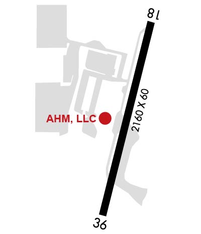 Airport Diagram might not be current. | |
| Facility Name: | FALLBROOK COMMUNITY AIRPARK |
| City Name: | FALLBROOK |
| County: | SAN DIEGO |
| State abbrev: | CA |
| State Name: | CALIFORNIA |
| Ownership: | PUBLICLY OWNED |
| Use: | OPEN TO THE PUBLIC |
| Owner's Name: | COUNTY OF SAN DIEGO |
| Address: | 1960 JOE CROSSON DRIVE |
| EL CAJON, CA 92020-1235 | |
| Owner's Phone: | 619-956-4800 |
| Manager's Name: | MEADOW CHASE |
| Address: | 2155 SOUTH MISSION ROAD |
| FALLBROOK, CA 92028 | |
| Phone: | 760-723-8395 |
| FAA Region: | WESTERN-PACIFIC |
| FAA Field Office: | LAX |
| Date | Sunrise | Sunset |
|---|---|---|
| 04/17/24 Wednesday | 6:15 | 19:22 |
| 04/18/24 Thursday | 6:14 | 19:23 |
| 04/19/24 Friday | 6:13 | 19:23 |
| 04/20/24 Saturday | 6:12 | 19:24 |
| 04/21/24 Sunday | 6:11 | 19:25 |
| 04/22/24 Monday | 6:10 | 19:26 |
| 04/23/24 Tuesday | 6:08 | 19:26 |
| 04/24/24 Wednesday | 6:07 | 19:27 |
| 04/25/24 Thursday | 6:06 | 19:28 |
| 04/26/24 Friday | 6:05 | 19:29 |
| 04/27/24 Saturday | 6:04 | 19:29 |
| 04/28/24 Sunday | 6:03 | 19:30 |
| 04/29/24 Monday | 6:02 | 19:31 |
| 04/30/24 Tuesday | 6:01 | 19:32 |
| Airport Attendance Schedule | MON-FRI 0900-1400 |
| Airport Status | OPERATIONAL (This Status can change at any time - please check NOTAMS) |
| Airport Lighting Schedule | MIRL RWY 18/36 MED INTST ONLY AVBL. ACTVT MIRL RWY 18/36 & TWY LGTS - CTAF (5 CLICKS ON). |
| Airport Storage Available | Tie Downs |
| Extra Services Available | Flight Instruction, Aircraft Rental, Aircraft Sales |
| Wind Indicator | YES - (unlit) |
| Control Tower | NO |
| CTAF Frequency | 123.050 |
| Unicom Frequency | |
| Rotating Beacon Color | WG |
| Segmented Circle | YES |
| Landing Fee | NO |
| Airport Inspected | STATE - performed by STATE AERONAUTICAL PERSONNEL |
| Inspection Date | 10/19/2021 |
| Type of Fuel Available | Grade 100LL; -10SELF-SERVICE FUEL AVBL 24 HRS. |
| Airframe Repair Service | MAJOR |
| Power Plant Repair Service | MAJOR |
| Latitude | N3321.3 |
| Longitude | W11715.1 (ESTIMATED) |
| Arpt Elevation | 708ft (ESTIMATED) |
| Magnetic Variation | 13E |
| 2 miles S | of FALLBROOK |
| Traffic Pattern Altitude | TPA - 1708(1000) FIXED WING, 1200(492) HEL. |
| Sectional Chart | LOS ANGELES |
| Operations (Reported) | Yearly | Avg. Daily |
|---|---|---|
| General Aviation Transient | 7356 | 20 |
| General Aviation Local | 13660 | 37 |
| Air Taxi | 0 | 0 |
| Commerical | 0 | 0 |
| Commuter | 0 | 0 |
| Military | 0 | 0 |
| Aircraft based on Field | |
|---|---|
| General Aviation Singles | 95 |
| General Aviation Multi | 2 |
| Jet Aircraft | 0 |
| General Aviation Helicopters | 0 |
| Military Aircraft | 0 |
| Gliders | 1 |
| Ultralights | 0 |
| FSS on field | NO |
| FSS tie-in | SAN DIEGO |
| FSS Phone | 1-800-WX-BRIEF |
| Who issues Notams | L18 |
| Notam D service at airport | YES |
| ARTCC Name | LOS ANGELES |
| Airport Certification | |
| Aircraft Rescue & Firefighting Index | None |
| Airport of Entry | No |
| Custom Landing Rights | No |
| Joint Civil/Military | No |
| Military Landing rights | YES |
| NATIONAL PLAN OF INTEGRATED AIRPORT SYSTEMS (NPIAS) |
| SURPLUS PROPERTY AGREEMENT UNDER PUBLIC LAW 289 |
| CONVEYANCE UNDER SCETION 16, FEDERAL AIRPORT ACT OF 1946 OR SECTION 23, AIRPORT AND AIRWAY DEVELOPMENT ACT OF 1970 |
| ASSURANCES PURSUANT TO TITLE VI, CIVIL RIGHTS ACT OF 1964 |
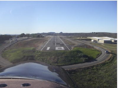
| NO SAFETY AREA AVBL DUE TO ABRUPT DROP-OFF EACH END OF RWY. |
| CONC HELIPAD CLOSED TO UNAUTHORIZED AIRCRAFT. |
| AP ADMIN BLDG EAST SIDE OF RWY; FUELING AREA WEST OF AFLD. |
| PART 77 OBSTRUCTION, +15 FT HILL 100 FT E OF RWY 18 CNTRLN. |
| ROTORCRAFT FUEL UNAVBL. RCMDD HEL TFC PAT APCH AND DEP AT 492 FT AGL TO AND FROM EAST AT MID RWY. HEL TGL RSTRD TO RWY. |
| HOVERS, SKID LANDINGS, AND AUTO-ROTATIONS PROHIBITED. |
| RWY 18 CALM WIND RWY |
| TRAN PRKG LCTD ON SE CORNER OF AFLD. |
| OCNL COYOTE ON OR IN THE VICINITY OF RWY AND TWY. |
| ACFT SHALL SELF-ANNOUNCE ON CTAF PRIOR TO LDG OR TKOF. |
| FOR CD CTC SOCAL APCH AT 800-448-3724. |
| NOISE ABATEMENT: TKOFS CLIMB STRAIGHT AHEAD TO 1200 FT MSL. RWY 18 TURN CROSSWIND WHEN ABEAM WATER TANK 1.1 MI ESE OF RWY. RWY 18 EXTEND DOWNWIND LEG TO ALLOW 1/3 MILE FINAL APCH. FLY DOWNWIND EAST OF HIGH SCHOOL. |
| PPR FOR ALL ACFT OVER 12000 LBS AND ALL MIL ACFT, CTC AMGR. |
| TWY HOLD BARS NON -STD DIST FM RY EDGE. |
| MIL BASE SW, FRQ MIL HELS IN VICINITY OF ARPT. |
| RWY H1 RSTD TO PUBLIC SAFETY ACFT. |
Airport Communications & Frequencies:
| ||||||||||||||||
| Runway: 18 | Runway: 36 | ||
| Mag heading: | 181° | Mag heading: | 1° |
| Rwy Slope: | -.42% Down | Rwy Slope: | .42% Up |
| Approach: | Approach: | ||
| Pattern: | Left Traffic | Pattern: | Right Traffic |
| Markings: | BASIC | Markings: | BASIC |
| Marking Condition: | GOOD | Marking Condition: | GOOD |
| Arresting Dev: | Arresting Dev: | ||
| Lat & Long: | N3321.4 W11715.0 | Lat. & Long.: | N3321.1 W11715.1 |
| Elev: | 708.0 ft. MSL | Elev: | 699.0 ft. MSL |
| TCH: | 20 ft. AGL | TCH: | |
| Visual Glide Path: | 4.00 degrees | Visual Glide Path: | |
| Displaced Threshold: | No | Displaced Threshold: | No |
| Touchdown Zone: | YES | Touchdown Zone: | YES |
| Touchdown Elev.: | 708.0 feet | Touchdown Elev.: | 708.0 feet |
| Visual Glide Slope: | PULSATING/STEADY BURNING VASI ON LEFT SIDE OF RUNWAY | Visual Glide Slope: | |
| RVR Equipment: | RVR Equipment: | ||
| RVV Equipment: | NO | RVV Equipment: | NO |
| Approach Lights: | Approach Lights: | ||
| REIL: | NO | REIL: | NO |
| Centerline Lights: | NO | Centerline Lights: | NO |
| Touchdown lights: | NO | Touchdown lights: | NO |
| Runway Category: | Runway with a Non-precision Approach | Runway Category: | Runway with a Visual Approach |
| Declared Distances: | Declared Distances: |