Click here for more info on on SMS!

KKY8

HANCOCK CO-RON LEWIS FIELD
LEWISPORT
KY
Time Zone: Central
Lat: N 3757.3
Long: W 08651.4
Elev: 411
Var: +03
Longest Runway: 5002
AWOS: 119.77
CTAF: 123.0

FBO & Flight Services info for KKY8

FBOs: Update your Fuel Prices

HANCOCK COPh: 270-295-4100
-
-
Service
Jet
100LL
SAF
MoGas
Fuel Avail: 24/7
Full        Last Update: 04/05/2024 08:49

Self4.795.47    
 Address: 500 AIRPORT RD,   LEWISPORT, KY 42351
AWOSPh: 270-295-3565
-
Freq: 119.77  
If you are an FBO, call 1-203-262-1700 to update your info or email: FltPlan.Advertising@garmin.com
Advertise your FBO on FltPlan.com

Runway & Approach Info for KKY8
Rwy
Length
Land Dist**
Approach*
  Rwy
Length
Land Dist**
Approach*
05
5002x75  5002'          
 
  
23
  5002x75  5002'          
 
 * only ILS, LOC, LDA, and SDF approaches to a specific runway are shown
** For any Declared Landing Distance Available, please see A/FD or Approach plates
Runway Weight Capability (lbs.) Help
Runway IDSingle WheelDouble WheelDouble Tandem WheelDual Double Wheel
05/2330,00040,000N/AN/A
These numbers are Advisory and are not limits.   The Airport Manager should have more accurate Weight Limits
Approach Charts
Approaches    
Current Weather/Notams
Customs Information Send updates to Support@FltPlan.com
Customs Not Available
Database effective 05/16/2024
Airport Diagram of KKY8
Airport Diagram might not be current.

Facility Name: HANCOCK COUNTY/RON LEWIS FLD
City Name: LEWISPORT
County: HANCOCK
State abbrev: KY
State Name: KENTUCKY
   
Ownership: PUBLICLY OWNED
Use: OPEN TO THE PUBLIC
Owner's Name: HANCOCK COUNTY AIRPORT BOARD; TIM POWERS
Address: 500 AIRPORT ROAD
 LEWISPORT, KY 42351
Owner's Phone: 270-570-1976
  
Manager's Name: TIM POWERS; AIRPORT BOARD CHAIRMAN TIM POWERS
Address: 500 AIRPORT ROAD
 LEWISPORT, KY 42351
Phone: 270-295-4100
   
FAA Region: SOUTHERN
FAA Field Office: MEM


Sunrise / Sunset times for HANCOCK COUNTY/RON LEWIS FLD

DateSunriseSunset
04/24/24 Wednesday5:5919:32
04/25/24 Thursday5:5819:33
04/26/24 Friday5:5619:34
04/27/24 Saturday5:5519:35
04/28/24 Sunday5:5419:36
04/29/24 Monday5:5319:37
04/30/24 Tuesday5:5219:38
05/01/24 Wednesday5:5019:39
05/02/24 Thursday5:4919:40
05/03/24 Friday5:4819:41
05/04/24 Saturday5:4719:42
05/05/24 Sunday5:4619:43
05/06/24 Monday5:4519:44
05/07/24 Tuesday5:4419:44

Airport Facilities

Airport Attendance Schedule7 Days A Week 0800-1700
Airport Status OPERATIONAL (This Status can change at any time - please check NOTAMS)
Airport Lighting ScheduleACTVT REIL RWY 05 & 23; MIRL RWY 5/23 - CTAF. PAPI RWY 05 & 23 OPR CONSLY.
Airport Storage AvailableTie Downs, Hanger
Extra Services AvailableNONE
Wind IndicatorYES - (lighted)
Control TowerNO
CTAF Frequency123.000
Unicom Frequency123.000
Rotating Beacon ColorWG
Segmented CircleYES
Landing Fee

Airport Inspection Data

Airport InspectedSTATE - performed by STATE AERONAUTICAL PERSONNEL
Inspection Date11/18/2020

Airport Services

Type of Fuel AvailableGrade 100LL, JET A; -10FUEL AVBL 24/7 WITH CC.
Airframe Repair ServiceNone
Power Plant Repair ServiceNone

Geographic Data

LatitudeN3757.3
LongitudeW08651.4 (ESTIMATED)
Arpt Elevation411ft (SURVEYED)
Magnetic Variation03W
3 miles NEof LEWISPORT
Traffic Pattern Altitude
Sectional ChartST LOUIS

Aircraft Data

Operations (Reported)YearlyAvg. Daily
General Aviation Transient 450012
General Aviation Local 500014
Air Taxi 7002
Commerical 00
Commuter 00
Military 1000
Aircraft based on Field
General Aviation Singles 19
General Aviation Multi 0
Jet Aircraft 0
General Aviation Helicopters 0
Military Aircraft 0
Gliders 0
Ultralights 0

FAA Services

FSS on field NO
FSS tie-in LOUISVILLE
FSS Phone 1-800-WX-BRIEF
Who issues Notams LOU
Notam D service at airport YES
ARTCC Name INDIANAPOLIS

Federal Status

Airport Certification
Aircraft Rescue & Firefighting IndexNone
Airport of EntryNo
Custom Landing RightsNo
Joint Civil/MilitaryNo
Military Landing rightsNo

Federal Agreements

NATIONAL PLAN OF INTEGRATED AIRPORT SYSTEMS (NPIAS)
GRANT AGREEMENTS UNDER FAAP/ADAP/AIP
ASSURANCES PURSUANT TO TITLE VI, CIVIL RIGHTS ACT OF 1964

Remarks

FOR CD CTC EVANSVILLE APCH AT 812-436-4690, WHEN APCH CLSD CTC INDIANAPOLIS ARTCC AT 317-247-2411.
Airport Communications & Frequencies:
CTAF Frequency:
123.000
Unicom Frequency:
123.000
Remarks
  • APCH/DEP SVC PRVDD BY INDIANAPOLIS ARTCC ON FREQS 128.3/291.625 (EVANSVILLE RCAG) WHEN EVANSVILLE APCH CTL CLSD.
  • EVANSVILLE Primary Approach Frequencies:  
    124.025
    290.9
    EVANSVILLE Primary Departure Frequencies:  
    124.025
    290.9
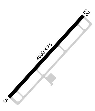
    Runway Identifications
    Runway Identification: 05/23
    Length: 5002 ft
    Width: 75 ft
    Surface: ASPHALT-GOOD CONDITION
    Edge lights: Medium Intensity

    Treatment: NONE

     Runway: 05   Runway: 23
    Mag heading: 46°Mag heading: 226°
    Rwy Slope: .04% UpRwy Slope: -.04% Down
    Approach: Approach:
    Pattern: Left TrafficPattern: Left Traffic
    Markings: NONPRECISION INSTRUMENTMarkings: NONPRECISION INSTRUMENT
    Marking Condition: FAIRMarking Condition: FAIR
    Arresting Dev: Arresting Dev:
    Lat & Long: N3756.9  W08651.7Lat. & Long.: N3757.6  W08651.0
    Elev: 409.3 ft. MSLElev: 411.3 ft. MSL
    TCH: 37 ft. AGLTCH: 45 ft. AGL
    Visual Glide Path: 3.50 degreesVisual Glide Path: 3.00 degrees
    Displaced Threshold: NoDisplaced Threshold: No
    Touchdown Zone: YESTouchdown Zone: YES
    Touchdown Elev.: 411.0 feetTouchdown Elev.: 411.4 feet
    Visual Glide Slope: 4-Light PAPI on LEFT side of RunwayVisual Glide Slope: 4-Light PAPI on LEFT side of Runway
    RVR Equipment: RVR Equipment:
    RVV Equipment: NORVV Equipment: NO
    Approach Lights: Approach Lights:
    REIL: YESREIL: YES
    Centerline Lights: NOCenterline Lights: NO
    Touchdown lights: NOTouchdown lights: NO
    Runway Category: Runway with a Non-precision Approach having visibility minimums greater than 3/4 mileRunway Category: Runway with a Non-precision Approach having visibility minimums greater than 3/4 mile
    Declared Distances: Declared Distances:
    Obstructions: ROADObstructions: TREE
    Marked: NOT Marked/LightedMarked: NOT Marked/Lighted
    Clearance slope: 29:1Clearance slope: 22:1
    Obstruction height: 9 feet AGLObstruction height: 55 feet AGL
    Dist. from runway: 468 feetDist. from runway: 1427 feet
    Centerline offset: Centerline offset: 430 feet right of centerline
    Comments: Comments:
    C:1/P: