Click here for more info on on SMS!

KKEK

EKWOK AIRPORT
EKWOK
AK
Time Zone: Alaska
Lat: N 5921.4
Long: W 15728.3
Elev: 141
Var: -17
Longest Runway: 3300
CTAF: 122.9

FBO & Flight Services info for KKEK

FBOs: Update your Fuel Prices

AIRPORTPh: 907-842-5511
-
Freq: 122.9
RUNWAY - GRAVEL
-
-
 
If you are an FBO, call 1-203-262-1700 to update your info or email: FltPlan.Advertising@garmin.com
Advertise your FBO on FltPlan.com

Runway & Approach Info for KKEK
Rwy
Length
Land Dist**
Approach*
  Rwy
Length
Land Dist**
Approach*
02
3300x75  3300'          
 
  
20
  3300x75  3300'          
 
 * only ILS, LOC, LDA, and SDF approaches to a specific runway are shown
** For any Declared Landing Distance Available, please see A/FD or Approach plates
Runway Weight Capability (lbs.) Help
Runway IDSingle WheelDouble WheelDouble Tandem WheelDual Double Wheel
02/20N/AN/AN/AN/A
These numbers are Advisory and are not limits.   The Airport Manager should have more accurate Weight Limits
Approach Charts
FltPlan does not have IFR approach charts available for KKEK.
Current Weather/Notams
Customs Information Send updates to Support@FltPlan.com
Customs Not Available
Database effective 05/16/2024
Airport Diagram of KKEK
Airport Diagram might not be current.

Facility Name: EKWOK
City Name: EKWOK
County: DILLINGHAM
State abbrev: AK
State Name: ALASKA
   
Ownership: PUBLICLY OWNED
Use: OPEN TO THE PUBLIC
Owner's Name: ALASKA DOT&PF CENTRAL REGION
Address: PO BOX 196900
 ANCHORAGE, AK 99519-6900
Owner's Phone: 907-269-0760
  
Manager's Name: JON TAYLOR
Address: BOX 250
 DILLINGHAM, AK 99576
Phone: 907-842-5511
   
FAA Region: ALASKA
FAA Field Office: NONE


Sunrise / Sunset times for EKWOK

DateSunriseSunset
04/24/24 Wednesday6:4722:10
04/25/24 Thursday6:4422:12
04/26/24 Friday6:4122:15
04/27/24 Saturday6:3922:17
04/28/24 Sunday6:3622:20
04/29/24 Monday6:3322:22
04/30/24 Tuesday6:3122:24
05/01/24 Wednesday6:2822:27
05/02/24 Thursday6:2622:29
05/03/24 Friday6:2322:32
05/04/24 Saturday6:2022:34
05/05/24 Sunday6:1822:36
05/06/24 Monday6:1522:39
05/07/24 Tuesday6:1322:41

Airport Facilities

Airport Attendance ScheduleUNATTENDED
Airport Status OPERATIONAL (This Status can change at any time - please check NOTAMS)
Airport Lighting ScheduleACTVT MIRL RWY 02/20 - CTAF.; ACTVT ROTG BCN - CTAF.
Airport Storage AvailableTie Downs
Extra Services AvailableNONE
Wind IndicatorYES - (lighted)
Control TowerNO
CTAF Frequency122.900
Unicom Frequency
Rotating Beacon ColorWG
Segmented CircleYES
Landing FeeNO

Airport Inspection Data

Airport InspectedSTATE - performed by PRIVATE CONTRACT PERSONNEL
Inspection Date06/30/2023

Airport Services

Type of Fuel AvailableNone
Airframe Repair ServiceNONE
Power Plant Repair ServiceNONE

Geographic Data

LatitudeN5921.4
LongitudeW15728.3 (ESTIMATED)
Arpt Elevation141ft (SURVEYED)
Magnetic Variation17E
0 miles NNWof EKWOK
Traffic Pattern Altitude
Sectional ChartKODIAK

Aircraft Data

Operations (Reported)YearlyAvg. Daily
General Aviation Transient 7002
General Aviation Local 00
Air Taxi 15004
Commerical 00
Commuter 00
Military 00
Aircraft based on Field
General Aviation Singles 0
General Aviation Multi 0
Jet Aircraft 0
General Aviation Helicopters 0
Military Aircraft 0
Gliders 0
Ultralights 0

FAA Services

FSS on field NO
FSS tie-in DILLINGHAM
FSS Phone 842-5275 (Local call)
Nearby FSS KENAI
Phone 1-800-866-864-1737
Who issues Notams DLG
Notam D service at airport YES
ARTCC Name ANCHORAGE

Federal Status

Airport Certification
Aircraft Rescue & Firefighting IndexNone
Airport of EntryNo
Custom Landing RightsNo
Joint Civil/MilitaryNo
Military Landing rightsYES

Federal Agreements

NATIONAL PLAN OF INTEGRATED AIRPORT SYSTEMS (NPIAS)
GRANT AGREEMENTS UNDER FAAP/ADAP/AIP
ASSURANCES PURSUANT TO TITLE VI, CIVIL RIGHTS ACT OF 1964

Remarks

BE ALERT: VEHICLES CROSS RWY.
RWY CONDITION NOT MONITORED; RECOMMEND VISUAL INSPECTION PRIOR TO USE.
WX CAMERA AVBL ON INTERNET AT HTTPS://WEATHERCAMS.FAA.GOV.
Airport Communications & Frequencies:
CTAF Frequency:
122.900
Remarks
  • COMMUNICATIONS PRVDD BY DILLINGHAM FSS ON FREQ 122.55 0745-2345 (KEMUK MOUNTAIN RCO) OTHER TIMES CTC KENAI FSS.
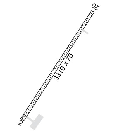
  • Runway Identifications
    Runway Identification: 02/20
    Length: 3300 ft
    Width: 75 ft
    Surface: GRAVEL-GOOD CONDITION
    Edge lights: Medium Intensity

    Treatment: NONE

     Runway: 02   Runway: 20
    Mag heading: 21°Mag heading: 201°
    Rwy Slope: .65% UpRwy Slope: -.65% Down
    Approach: Approach:
    Pattern: Left TrafficPattern: Left Traffic
    Markings: NONSTANDARDMarkings: NONE
    Marking Condition: FAIRMarking Condition: FAIR
    Arresting Dev: Arresting Dev:
    Lat & Long: N5921.2  W15728.6Lat. & Long.: N5921.6  W15727.9
    Elev: 119.3 ft. MSLElev: 140.7 ft. MSL
    TCH: TCH:
    Visual Glide Path: Visual Glide Path:
    Displaced Threshold: NoDisplaced Threshold: No
    Touchdown Zone: YESTouchdown Zone: YES
    Touchdown Elev.: 138.3 feetTouchdown Elev.: 141.0 feet
    Visual Glide Slope: Visual Glide Slope:
    RVR Equipment: RVR Equipment:
    RVV Equipment: NORVV Equipment: NO
    Approach Lights: Approach Lights:
    REIL: NOREIL: NO
    Centerline Lights: NOCenterline Lights: NO
    Touchdown lights: NOTouchdown lights: NO
    Runway Category: Runway with a Visual ApproachRunway Category: Runway with a Visual Approach
    Declared Distances: Declared Distances:
    Obstructions: BRUSHObstructions: BRUSH
    Marked: NOT Marked/LightedMarked: NOT Marked/Lighted
    Clearance slope: CONTROLLING OBSTRUCTION EXCEEDS A 45 DEGREE SLOPEClearance slope:
    Obstruction height: 8 feet AGLObstruction height: 7 feet AGL
    Dist. from runway: 0 feetDist. from runway: 0 feet
    Centerline offset: 123 right of centerlineCenterline offset: 124 feet left of centerline
    Comments: Comments:
    C:/P: