Current Weather/Notams (Metars, TAFs, Notams, NWS Forecast, PIREPS, and nearby weather)
Customs Information Send updates to Support@FltPlan.com
Customs Not Available
Database effective 05/16/2024
Airport Diagram might not be current.
|
| Facility Name: | ALLEN COUNTY |
| City Name: | IOLA |
| County: | ALLEN |
| State abbrev: | KS |
| State Name: | KANSAS |
| | |
| Ownership: | PUBLICLY OWNED |
| Use: | OPEN TO THE PUBLIC |
| Owner's Name: | ALLEN COUNTY |
| Address: | COUNTY COURTHOUSE |
| | IOLA, KS 66749 |
| Owner's Phone: | 620-365-1422 |
| | |
| Manager's Name: | ROBERT POYDACK |
| Address: | 1705 MINNESOTA RD |
| | IOLA, KS 66749 |
| Phone: | 620-212-1316 |
| | |
| FAA Region: | CENTRAL |
| FAA Field Office: | NONE |
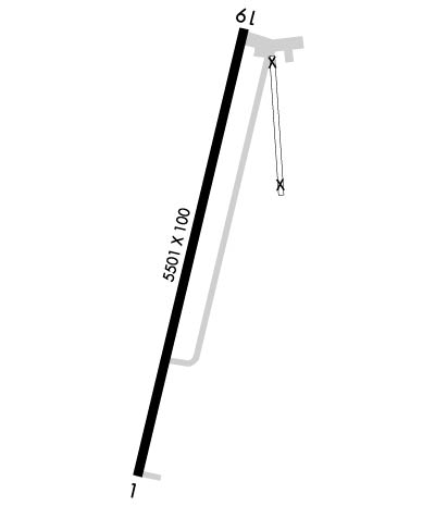
Runway Identifications
Runway Identification: 01/19Length: 5501 ft
Width: 100 ft
Surface: CONCRETE-GOOD CONDITION
Edge lights: High IntensityTreatment: NONE
Weight: PCN 11 /R/C/X/U
| | Runway: 01 | | Runway: 19 |
| Mag heading: | 9° | Mag heading: | 189° |
| Rwy Slope: | .19% Up | Rwy Slope: | -.19% Down |
| Approach: | | Approach: | |
| Pattern: | Left Traffic | Pattern: | Left Traffic |
| Markings: | NONPRECISION INSTRUMENT | Markings: | NONPRECISION INSTRUMENT |
| Marking Condition: | GOOD | Marking Condition: | GOOD |
| Arresting Dev: | | Arresting Dev: | |
| Lat & Long: | N3751.7 W09523.3 | Lat. & Long.: | N3752.5 W09523.1 |
| Elev: | 1004.9 ft. MSL | Elev: | 1015.6 ft. MSL |
| TCH: | 55 ft. AGL | TCH: | 52 ft. AGL |
| Visual Glide Path: | 3.00 degrees | Visual Glide Path: | 3.00 degrees |
| Displaced Threshold: | No | Displaced Threshold: | No |
| Touchdown Zone: | YES | Touchdown Zone: | YES |
| Touchdown Elev.: | 1014.0 feet | Touchdown Elev.: | 1015.6 feet |
| Visual Glide Slope: | 4-Light PAPI on LEFT side of Runway | Visual Glide Slope: | 4-Light PAPI on LEFT side of Runway |
| RVR Equipment: | | RVR Equipment: | |
| RVV Equipment: | NO | RVV Equipment: | NO |
| Approach Lights: | | Approach Lights: | |
| REIL: | NO | REIL: | NO |
| Centerline Lights: | NO | Centerline Lights: | NO |
| Touchdown lights: | NO | Touchdown lights: | NO |
| Runway Category: | Runway with a Non-precision Approach having visibility minimums greater than 3/4 mile | Runway Category: | Runway with a Non-precision Approach having visibility minimums greater than 3/4 mile |
| Declared Distances: | | Declared Distances: | |
| Obstructions: | POLE | Obstructions: | TREE |
| Marked: | NOT Marked/Lighted | Marked: | NOT Marked/Lighted |
| Clearance slope: | 26:1 | Clearance slope: | 29:1 |
| Obstruction height: | 42 feet AGL | Obstruction height: | 33 feet AGL |
| Dist. from runway: | 1330 feet | Dist. from runway: | 1180 feet |
| Centerline offset: | | Centerline offset: | 200 feet left of centerline |
| Comments: | | Comments: | |

