Current Weather/Notams (Metars, TAFs, Notams, NWS Forecast, PIREPS, and nearby weather)
Customs Information Send updates to Support@FltPlan.com
Customs Not Available
Database effective 05/16/2024
Airport Diagram might not be current.
|
| Facility Name: | SMITH CENTER MUNI |
| City Name: | SMITH CENTER |
| County: | SMITH |
| State abbrev: | KS |
| State Name: | KANSAS |
| | |
| Ownership: | PUBLICLY OWNED |
| Use: | OPEN TO THE PUBLIC |
| Owner's Name: | CITY OF SMITH CENTER |
| Address: | SMITH CENTER |
| | SMITH CENTER, KS 66967 |
| Owner's Phone: | |
| | |
| Manager's Name: | CITY OF SMITH CENTER |
| Address: | 119 WEST COURT |
| | SMITH CENTER, KS 66967 |
| Phone: | 785-282-3812 |
| | |
| FAA Region: | CENTRAL |
| FAA Field Office: | NONE |
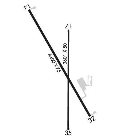
Runway Identifications
Runway Identification: 14/32Length: 4400 ft
Width: 75 ft
Surface: CONCRETE-GOOD CONDITION
Edge lights: Medium IntensityTreatment: NONE
Weight: PCN 11 /R/C/X/U
| | Runway: 14 | | Runway: 32 |
| Mag heading: | 144° | Mag heading: | 324° |
| Rwy Slope: | .31% Up | Rwy Slope: | -.31% Down |
| Approach: | | Approach: | |
| Pattern: | Left Traffic | Pattern: | Left Traffic |
| Markings: | NONPRECISION INSTRUMENT | Markings: | NONPRECISION INSTRUMENT |
| Marking Condition: | GOOD | Marking Condition: | GOOD |
| Arresting Dev: | | Arresting Dev: | |
| Lat & Long: | N3946.1 W09847.9 | Lat. & Long.: | N3945.5 W09847.5 |
| Elev: | 1785.7 ft. MSL | Elev: | 1799.5 ft. MSL |
| TCH: | 40 ft. AGL | TCH: | 40 ft. AGL |
| Visual Glide Path: | 3.00 degrees | Visual Glide Path: | 3.00 degrees |
| Displaced Threshold: | No | Displaced Threshold: | No |
| Touchdown Zone: | YES | Touchdown Zone: | YES |
| Touchdown Elev.: | 1797.9 feet | Touchdown Elev.: | 1799.5 feet |
| Visual Glide Slope: | 4-Light PAPI on LEFT side of Runway | Visual Glide Slope: | 4-Light PAPI on LEFT side of Runway |
| RVR Equipment: | | RVR Equipment: | |
| RVV Equipment: | NO | RVV Equipment: | NO |
| Approach Lights: | | Approach Lights: | |
| REIL: | YES | REIL: | YES |
| Centerline Lights: | NO | Centerline Lights: | NO |
| Touchdown lights: | NO | Touchdown lights: | NO |
| Runway Category: | Runway with a Non-precision Approach having visibility minimums greater than 3/4 mile | Runway Category: | Runway with a Non-precision Approach having visibility minimums greater than 3/4 mile |
| Declared Distances: | | Declared Distances: | |
| Obstructions: | Unknown | Obstructions: | |
| Marked: | NOT Marked/Lighted | Marked: | |
| Clearance slope: | 20:1 | Clearance slope: | 20:1 |
| Obstruction height: | CROPS VARY IN HEIGHT 0-6 FT. | Obstruction height: | |
| Dist. from runway: | | Dist. from runway: | |
| Centerline offset: | | Centerline offset: | |
| Comments: | | Comments: | |
Runway Identification: 18/36Length: 3601 ft
Width: 50 ft
Surface: ASPHALT-FAIR CONDITION
Edge lights: Treatment: NONE
Weight: PCN 5 /F/C/Y/U
| | Runway: 18 | | Runway: 36 |
| Mag heading: | 173° | Mag heading: | 353° |
| Rwy Slope: | -.26% Down | Rwy Slope: | .26% Up |
| Approach: | | Approach: | |
| Pattern: | Left Traffic | Pattern: | Left Traffic |
| Markings: | NONPRECISION INSTRUMENT | Markings: | NONPRECISION INSTRUMENT |
| Marking Condition: | GOOD; RWY 18 NO MKGS FOR NPI RWY. | Marking Condition: | GOOD; RWY 36 NO MKGS FOR NPI RWY. |
| Arresting Dev: | | Arresting Dev: | |
| Lat & Long: | N3946.0 W09847.6 | Lat. & Long.: | N3945.4 W09847.6 |
| Elev: | 1796.5 ft. MSL | Elev: | 1787.2 ft. MSL |
| TCH: | | TCH: | |
| Visual Glide Path: | | Visual Glide Path: | |
| Displaced Threshold: | No | Displaced Threshold: | 101 feet |
| Touchdown Zone: | YES | Touchdown Zone: | YES |
| Touchdown Elev.: | 1797.7 feet | Touchdown Elev.: | 1797.8 feet |
| Visual Glide Slope: | | Visual Glide Slope: | |
| RVR Equipment: | | RVR Equipment: | |
| RVV Equipment: | NO | RVV Equipment: | NO |
| Approach Lights: | | Approach Lights: | |
| REIL: | NO | REIL: | NO |
| Centerline Lights: | NO | Centerline Lights: | NO |
| Touchdown lights: | NO | Touchdown lights: | NO |
| Runway Category: | Runway with a Non-precision Approach | Runway Category: | Runway with a Non-precision Approach |
| Declared Distances: | TORA:3601' TODA:3601' ASDA:3500' LDA:3601' | Declared Distances: | TORA:3601' TODA:3601' ASDA:3601' LDA:3500' |
| Obstructions: | | Obstructions: | ROAD |
| Marked: | | Marked: | NOT Marked/Lighted |
| Clearance slope: | 50:1 | Clearance slope: | 1:1; APCH SLOPE 21:1 FROM DSPLCD THLD. |
| Obstruction height: | | Obstruction height: | 15 feet AGL |
| Dist. from runway: | | Dist. from runway: | 225 feet |
| Centerline offset: | | Centerline offset: | |
| Comments: | | Comments: | |
