Current Weather/Notams (Metars, TAFs, Notams, NWS Forecast, PIREPS, and nearby weather)
Customs Information Send updates to Support@FltPlan.com
Customs Not Available
Database effective 05/16/2024
Airport Diagram might not be current.
|
| Facility Name: | MIAMI COUNTY |
| City Name: | PAOLA |
| County: | MIAMI |
| State abbrev: | KS |
| State Name: | KANSAS |
| | |
| Ownership: | PUBLICLY OWNED |
| Use: | OPEN TO THE PUBLIC |
| Owner's Name: | MIAMI COUNTY; SHANE KRULL, CO. ADMINISTRATOR. |
| Address: | 201 S. PEARL |
| | PAOLA, KS 66071 |
| Owner's Phone: | 913-294-9500 |
| | |
| Manager's Name: | CHARLES BARTLETT; CHASBART@EMBARQMAIL.COM |
| Address: | 32549 W 327TH ST |
| | PAOLA, KS 66071 |
| Phone: | 913-707-8372 |
| | |
| FAA Region: | CENTRAL |
| FAA Field Office: | NONE |
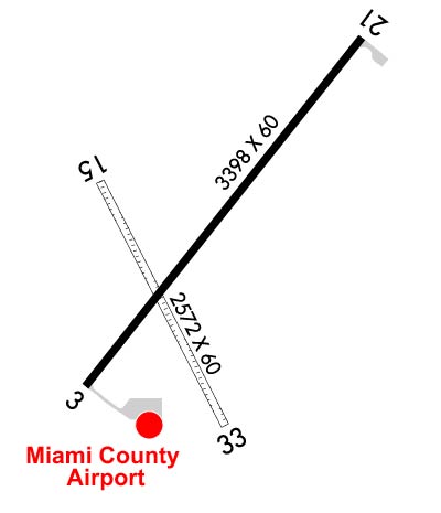
Runway Identifications
Runway Identification: 03/21Length: 3398 ft
Width: 60 ft
Surface: ASPHALT-GOOD CONDITION
Edge lights: Medium IntensityTreatment: NONE
Weight: PCN 8 /F/D/Y/U
| | Runway: 03 | | Runway: 21 |
| Mag heading: | 35° | Mag heading: | 215° |
| Rwy Slope: | .06% Up | Rwy Slope: | -.06% Down |
| Approach: | | Approach: | |
| Pattern: | Left Traffic | Pattern: | Left Traffic |
| Markings: | NONPRECISION INSTRUMENT | Markings: | NONPRECISION INSTRUMENT |
| Marking Condition: | GOOD | Marking Condition: | GOOD |
| Arresting Dev: | | Arresting Dev: | |
| Lat & Long: | N3832.2 W09455.4 | Lat. & Long.: | N3832.7 W09455.0 |
| Elev: | 938.8 ft. MSL | Elev: | 940.7 ft. MSL |
| TCH: | 40 ft. AGL | TCH: | 40 ft. AGL |
| Visual Glide Path: | 3.40 degrees | Visual Glide Path: | 3.00 degrees |
| Displaced Threshold: | No | Displaced Threshold: | No |
| Touchdown Zone: | YES | Touchdown Zone: | YES |
| Touchdown Elev.: | 941.1 feet | Touchdown Elev.: | 941.3 feet |
| Visual Glide Slope: | 2-Light PAPI on LEFT side of Runway | Visual Glide Slope: | 2-Light PAPI on LEFT side of Runway |
| RVR Equipment: | | RVR Equipment: | |
| RVV Equipment: | NO | RVV Equipment: | NO |
| Approach Lights: | | Approach Lights: | |
| REIL: | YES | REIL: | YES |
| Centerline Lights: | NO | Centerline Lights: | NO |
| Touchdown lights: | NO | Touchdown lights: | NO |
| Runway Category: | Runway with a Non-precision Approach | Runway Category: | Runway with a Non-precision Approach |
| Declared Distances: | | Declared Distances: | |
| Obstructions: | PLINE | Obstructions: | TREE |
| Marked: | NOT Marked/Lighted | Marked: | NOT Marked/Lighted |
| Clearance slope: | 32:1 | Clearance slope: | 27:1 |
| Obstruction height: | 35 feet AGL | Obstruction height: | 31 feet AGL |
| Dist. from runway: | 1320 feet | Dist. from runway: | 1060 feet |
| Centerline offset: | 215 right of centerline | Centerline offset: | 225 feet left of centerline |
| Comments: | | Comments: | |
Runway Identification: 15/33Length: 1940 ft
Width: 60 ft
Surface: GRASS-FAIR CONDITION
Edge lights: Treatment: NONE
| | Runway: 15 | | Runway: 33 |
| Mag heading: | 150° | Mag heading: | 330° |
| Rwy Slope: | .78% Up | Rwy Slope: | -.78% Down |
| Approach: | | Approach: | |
| Pattern: | Left Traffic | Pattern: | Left Traffic |
| Markings: | | Markings: | |
| Marking Condition: | | Marking Condition: | |
| Arresting Dev: | | Arresting Dev: | |
| Lat & Long: | N3832.5 W09455.4 | Lat. & Long.: | N3832.2 W09455.2 |
| Elev: | 925.9 ft. MSL | Elev: | 941.0 ft. MSL |
| TCH: | | TCH: | |
| Visual Glide Path: | | Visual Glide Path: | |
| Displaced Threshold: | No | Displaced Threshold: | No |
| Touchdown Zone: | YES | Touchdown Zone: | YES |
| Touchdown Elev.: | 941.0 feet | Touchdown Elev.: | 941.0 feet |
| Visual Glide Slope: | | Visual Glide Slope: | |
| RVR Equipment: | | RVR Equipment: | |
| RVV Equipment: | NO | RVV Equipment: | NO |
| Approach Lights: | | Approach Lights: | |
| REIL: | NO | REIL: | NO |
| Centerline Lights: | NO | Centerline Lights: | NO |
| Touchdown lights: | NO | Touchdown lights: | NO |
| Runway Category: | Runway with a Visual Approach | Runway Category: | Runway with a Visual Approach |
| Declared Distances: | | Declared Distances: | |