Click here for more info on on SMS!

KK77

FREEDOM MUNI
FREEDOM
OK
Time Zone: Central
Lat: N 3645.5
Long: W 09906.1
Elev: 1517
Var: -08
Longest Runway: 3000
CTAF: 122.9

FBO & Flight Services info for KK77

FBOs: Update your Fuel Prices

AIRPORT MANAGERPh: 580-621-3585
-
-
Service
Jet
100LL
SAF
MoGas
Fuel Avail: NO FUEL AVAILABLE
Full        Last Update: 04/23/2024 05:40:08

Self        
If you are an FBO, call 1-203-262-1700 to update your info or email: FltPlan.Advertising@garmin.com
Advertise your FBO on FltPlan.com

Runway & Approach Info for KK77
Rwy
Length
Land Dist**
Approach*
  Rwy
Length
Land Dist**
Approach*
12
3000x35  3000'          
 
  
30
  3000x35  3000'          
 
 * only ILS, LOC, LDA, and SDF approaches to a specific runway are shown
** For any Declared Landing Distance Available, please see A/FD or Approach plates
Runway Weight Capability (lbs.) Help
Runway IDSingle WheelDouble WheelDouble Tandem WheelDual Double Wheel
12/30N/AN/AN/AN/A
These numbers are Advisory and are not limits.   The Airport Manager should have more accurate Weight Limits
Approach Charts
FltPlan does not have IFR approach charts available for KK77.
Current Weather/Notams
Customs Information Send updates to Support@FltPlan.com
Customs Not Available
Database effective 05/16/2024
Airport Diagram of KK77
Airport Diagram might not be current.

Facility Name: FREEDOM MUNI
City Name: FREEDOM
County: WOODS
State abbrev: OK
State Name: OKLAHOMA
   
Ownership: PUBLICLY OWNED
Use: OPEN TO THE PUBLIC
Owner's Name: TOWN OF FREEDOM
Address: 1149 MAIN ST
 FREEDOM, OK 73842
Owner's Phone: 580-621-3302
  
Manager's Name: CONCHA HERRERA; MAYOR
Address: P. O. BOX 173
 FREEDOM, OK 73842
Phone: (580) 621-3302
   
FAA Region: SOUTHWEST
FAA Field Office: AOK


Sunrise / Sunset times for FREEDOM MUNI

DateSunriseSunset
04/22/24 Monday6:5220:18
04/23/24 Tuesday6:5120:19
04/24/24 Wednesday6:5020:20
04/25/24 Thursday6:4920:20
04/26/24 Friday6:4720:21
04/27/24 Saturday6:4620:22
04/28/24 Sunday6:4520:23
04/29/24 Monday6:4420:24
04/30/24 Tuesday6:4320:25
05/01/24 Wednesday6:4220:26
05/02/24 Thursday6:4120:27
05/03/24 Friday6:3920:27
05/04/24 Saturday6:3820:28
05/05/24 Sunday6:3720:29

Airport Facilities

Airport Attendance ScheduleUNATTENDED
Airport Status OPERATIONAL (This Status can change at any time - please check NOTAMS)
Airport Lighting Schedule
Airport Storage AvailableNONE
Extra Services AvailableNONE
Wind IndicatorNONE
Control TowerNO
CTAF Frequency122.900
Unicom Frequency
Rotating Beacon Color
Segmented CircleNO
Landing FeeNO

Airport Inspection Data

Airport InspectedSTATE - performed by STATE AERONAUTICAL PERSONNEL
Inspection Date07/10/2023

Airport Services

Type of Fuel AvailableNone
Airframe Repair ServiceNONE
Power Plant Repair ServiceNONE

Geographic Data

LatitudeN3645.5
LongitudeW09906.1 (ESTIMATED)
Arpt Elevation1517ft (SURVEYED)
Magnetic Variation08E
1 miles SEof FREEDOM
Traffic Pattern Altitude
Sectional ChartWICHITA

Aircraft Data

Operations (Reported)YearlyAvg. Daily
General Aviation Transient 00
General Aviation Local 00
Air Taxi 00
Commerical 00
Commuter 00
Military 00
Aircraft based on Field
General Aviation Singles 0
General Aviation Multi 0
Jet Aircraft 0
General Aviation Helicopters 0
Military Aircraft 0
Gliders 0
Ultralights 0

FAA Services

FSS on field NO
FSS tie-in MC ALESTER
FSS Phone 1-800-WX-BRIEF
Who issues Notams MLC
Notam D service at airport YES
ARTCC Name KANSAS CITY

Federal Status

Airport Certification
Aircraft Rescue & Firefighting IndexNone
Airport of EntryNo
Custom Landing RightsNo
Joint Civil/MilitaryNo
Military Landing rightsNo

Remarks

FOR CD CTC KANSAS CITY ARTCC AT 913-254-8508.
RWY 12/3 0 RWY EDGES & THLDS UNIDBL. FIRST 150 FT OF RWY 12 & FIRST 400 FT OF RWY 30 CVRD IN GRASS. RWY SFC ROUGH & UNEVEN. BROKEN ASPH, ROCKS, & TALL GRASS ENTR SFC. OCNL EQUIP ON RWY SFC.
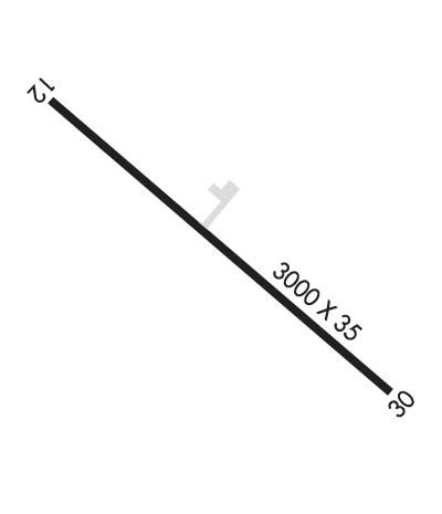
Runway Identifications
Runway Identification: 12/30
Length: 3000 ft
Width: 35 ft
Surface: ASPHALT
Edge lights:

Treatment: NONE

 Runway: 12   Runway: 30
Mag heading: N/AMag heading: N/A
Approach: Approach:
Pattern: Left TrafficPattern: Left Traffic
Markings: NONEMarkings: NONE
Marking Condition: Marking Condition:
Arresting Dev: Arresting Dev:
Lat & Long:   Lat. & Long.:   
Elev: N/AElev: N/A
TCH: TCH:
Visual Glide Path: Visual Glide Path:
Displaced Threshold: NoDisplaced Threshold: No
Touchdown Zone: NOTouchdown Zone: NO
Touchdown Elev.: Touchdown Elev.:
Visual Glide Slope: Visual Glide Slope:
RVR Equipment: RVR Equipment:
RVV Equipment: NORVV Equipment: NO
Approach Lights: Approach Lights:
REIL: NOREIL: NO
Centerline Lights: NOCenterline Lights: NO
Touchdown lights: NOTouchdown lights: NO
Runway Category: Runway with a Visual ApproachRunway Category: Runway with a Visual Approach
Declared Distances: Declared Distances:
Obstructions: TREESObstructions:
Marked: NOT Marked/LightedMarked:
Clearance slope: 1:1Clearance slope: 20:1
Obstruction height: 46 feet AGLObstruction height:
Dist. from runway: 281 feetDist. from runway:
Centerline offset: 131 left of centerlineCenterline offset:
Comments: 15 FT TREES 190 FT FM THLD 90 FT L OF CNTRLN.Comments:
C:/P: