Current Weather/Notams (Metars, TAFs, Notams, NWS Forecast, PIREPS, and nearby weather)
Customs Information Send updates to Support@FltPlan.com
Customs Not Available
Database effective 04/18/2024
Airport Diagram might not be current.
|
| Facility Name: | GENE SNYDER |
| City Name: | FALMOUTH |
| County: | PENDLETON |
| State abbrev: | KY |
| State Name: | KENTUCKY |
| | |
| Ownership: | PUBLICLY OWNED |
| Use: | OPEN TO THE PUBLIC |
| Owner's Name: | DAN BELL, ARPT BOARD CHAIRMAN |
| Address: | 400 GENE SNYDER AIRPORT DRIVE |
| | FALMOUTH, KY 41040 |
| Owner's Phone: | 859-654-1200 |
| | |
| Manager's Name: | DAN BELL |
| Address: | 400 GENE SNYDER AIRPORT DRIVE |
| | FALMOUTH, KY 41040 |
| Phone: | 859-654-1200 |
| | |
| FAA Region: | SOUTHERN |
| FAA Field Office: | MEM |
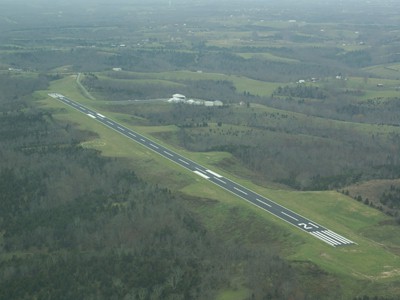
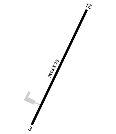
Runway Identifications
Runway Identification: 03/21Length: 3994 ft
Width: 75 ft
Surface: ASPHALT-GOOD CONDITION
Edge lights: Medium IntensityTreatment: NONE
| | Runway: 03 | | Runway: 21 |
| Mag heading: | 31° | Mag heading: | 211° |
| Rwy Slope: | -.36% Down | Rwy Slope: | .36% Up |
| Approach: | | Approach: | |
| Pattern: | Left Traffic | Pattern: | Left Traffic |
| Markings: | NONPRECISION INSTRUMENT | Markings: | NONPRECISION INSTRUMENT |
| Marking Condition: | GOOD | Marking Condition: | GOOD |
| Arresting Dev: | | Arresting Dev: | |
| Lat & Long: | N3841.9 W08423.7 | Lat. & Long.: | N3842.5 W08423.3 |
| Elev: | 899.2 ft. MSL | Elev: | 884.7 ft. MSL |
| TCH: | | TCH: | 38 ft. AGL |
| Visual Glide Path: | | Visual Glide Path: | 3.50 degrees |
| Displaced Threshold: | 100 feet | Displaced Threshold: | No |
| Touchdown Zone: | NO | Touchdown Zone: | YES |
| Touchdown Elev.: | | Touchdown Elev.: | 899.2 feet |
| Visual Glide Slope: | | Visual Glide Slope: | 4-Light PAPI on LEFT side of Runway; PAPI UNUSBL BYD 8 DEGS LEFT & 6 DEGS RIGHT OF CNTRLN. |
| RVR Equipment: | | RVR Equipment: | |
| RVV Equipment: | NO | RVV Equipment: | NO |
| Approach Lights: | | Approach Lights: | |
| REIL: | YES | REIL: | YES |
| Centerline Lights: | NO | Centerline Lights: | NO |
| Touchdown lights: | NO | Touchdown lights: | NO |
| Runway Category: | Runway with a Visual Approach | Runway Category: | Runway with a Non-precision Approach |
| Declared Distances: | TORA:3994' TODA:3994' ASDA:3994' LDA:3894' | Declared Distances: | TORA:3994' TODA:3994' ASDA:3894' LDA:3894' |
| Obstructions: | TREES | Obstructions: | TREES |
| Marked: | NOT Marked/Lighted | Marked: | NOT Marked/Lighted |
| Clearance slope: | 7:1 | Clearance slope: | 8:1 |
| Obstruction height: | 65 feet AGL | Obstruction height: | 18 feet AGL |
| Dist. from runway: | 673 feet | Dist. from runway: | 354 feet |
| Centerline offset: | 265 right of centerline | Centerline offset: | 234 feet left of centerline |
| Comments: | | Comments: | +8 TREES AT RWY END 155 FT R OF CNTRLN. |