
| ||||||||||||||||||||||||||||||||||||||||||||
| ||||||||||||||||||||||||||||||||||||||||||||
| ||||||||||||||||||||||||||||||||||||||||||||
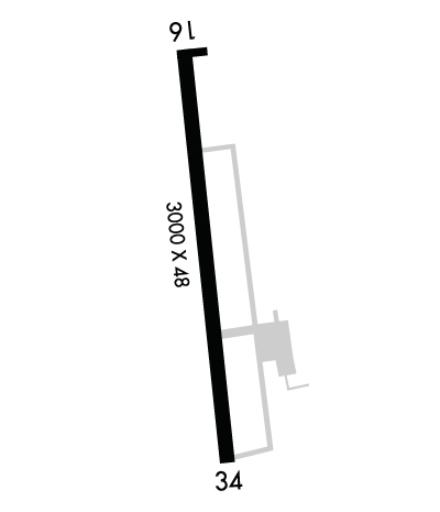
| Rwy | Rwy | |||||||
| 3000x48 | 3000' | 3000x48 | 2798' | |||||
| Runway ID | Single Wheel | Double Wheel | Double Tandem Wheel | Dual Double Wheel |
| 16/34 | 17,000 | N/A | N/A | N/A |
| These numbers are Advisory and are not limits. The Airport Manager should have more accurate Weight Limits | ||||
 Airport Diagram might not be current. | |
| Facility Name: | AMELIA EARHART |
| City Name: | ATCHISON |
| County: | ATCHISON |
| State abbrev: | KS |
| State Name: | KANSAS |
| Ownership: | PUBLICLY OWNED |
| Use: | OPEN TO THE PUBLIC |
| Owner's Name: | CITY OF ATCHISON |
| Address: | 515 KANSAS AVE |
| ATCHISON, KS 66002 | |
| Owner's Phone: | 913-367-5500 |
| Manager's Name: | CLINTON MCNEMEE |
| Address: | 515 KANSAS AVE |
| ATCHISON, KS 66002 | |
| Phone: | 913-426-0311; ALT PH NUMBER 913-568-3819. |
| FAA Region: | CENTRAL |
| FAA Field Office: | NONE |
| Date | Sunrise | Sunset |
|---|---|---|
| 04/26/24 Friday | 6:27 | 20:10 |
| 04/27/24 Saturday | 6:26 | 20:11 |
| 04/28/24 Sunday | 6:24 | 20:12 |
| 04/29/24 Monday | 6:23 | 20:13 |
| 04/30/24 Tuesday | 6:22 | 20:14 |
| 05/01/24 Wednesday | 6:21 | 20:15 |
| 05/02/24 Thursday | 6:19 | 20:16 |
| 05/03/24 Friday | 6:18 | 20:17 |
| 05/04/24 Saturday | 6:17 | 20:18 |
| 05/05/24 Sunday | 6:16 | 20:19 |
| 05/06/24 Monday | 6:15 | 20:20 |
| 05/07/24 Tuesday | 6:14 | 20:21 |
| 05/08/24 Wednesday | 6:13 | 20:22 |
| 05/09/24 Thursday | 6:12 | 20:23 |
| Airport Attendance Schedule | 7 Days A Week 0900-1900 |
| Airport Status | OPERATIONAL (This Status can change at any time - please check NOTAMS) |
| Airport Lighting Schedule | ACTVT LIRL RWY 16/34 - CTAF. |
| Airport Storage Available | Tie Downs, Hanger |
| Extra Services Available | Crop Dusting, Glider, Flight Instruction, Aircraft Rental, Glider Towing |
| Wind Indicator | YES - (lighted) |
| Control Tower | NO |
| CTAF Frequency | 122.800 |
| Unicom Frequency | 122.800 |
| Rotating Beacon Color | WG |
| Segmented Circle | NO |
| Landing Fee | NO |
| Airport Inspected | STATE - performed by STATE AERONAUTICAL PERSONNEL |
| Inspection Date | 09/27/2022 |
| Type of Fuel Available | Grade 100LL, JET A; -A+24 HR SELF SVC FUEL AVBL. |
| Airframe Repair Service | MAJOR |
| Power Plant Repair Service | MAJOR |
| Latitude | N3934.2 |
| Longitude | W09510.8 (ESTIMATED) |
| Arpt Elevation | 1073ft (SURVEYED) |
| Magnetic Variation | 02E |
| 2 miles W | of ATCHISON |
| Traffic Pattern Altitude | |
| Sectional Chart | KANSAS CITY |
| Operations (Reported) | Yearly | Avg. Daily |
|---|---|---|
| General Aviation Transient | 5000 | 14 |
| General Aviation Local | 11000 | 30 |
| Air Taxi | 50 | 0 |
| Commerical | 0 | 0 |
| Commuter | 0 | 0 |
| Military | 50 | 0 |
| Aircraft based on Field | |
|---|---|
| General Aviation Singles | 21 |
| General Aviation Multi | 2 |
| Jet Aircraft | 0 |
| General Aviation Helicopters | 0 |
| Military Aircraft | 0 |
| Gliders | 1 |
| Ultralights | 0 |
| FSS on field | NO |
| FSS tie-in | WICHITA |
| FSS Phone | 1-800-WX-BRIEF |
| Who issues Notams | ICT |
| Notam D service at airport | YES |
| ARTCC Name | KANSAS CITY |
| Airport Certification | |
| Aircraft Rescue & Firefighting Index | None |
| Airport of Entry | No |
| Custom Landing Rights | No |
| Joint Civil/Military | No |
| Military Landing rights | YES |
| NATIONAL PLAN OF INTEGRATED AIRPORT SYSTEMS (NPIAS) |
| GRANT AGREEMENTS UNDER FAAP/ADAP/AIP |
| ASSURANCES PURSUANT TO TITLE VI, CIVIL RIGHTS ACT OF 1964 |
| THIS AIRPORT HAS BEEN SURVEYED BY THE NATIONAL GEODETIC SURVEY. |
| GLIDER OPNS FM GRASS WEST SIDE OF RWY. |
| A HEAVY CROPDUSTING OPS. |
| FOR CD CTC KANSAS CITY APCH AT 816-329-2710. |
| CTN - ROAD AND TREES 15 - 55 FT AGL; 302 - 438 FT FM RWY 34 THLD; 0-225 FT L AND R. |
| (CONTACT TITLE) INTERIM CITY MGR BECKY BERGER, ALTN CLINTON MCNEMEE 913-367-5561. |
| RWY 16/3 4 LN OF SIGHT OBSTD BTWN RWY ENDS. |
| RWY 16/3 4 RWY 16/34 NSTD LIRL; RY END LGTS AT DEP END RY 16 ARE NOT SPLIT LENSES. SOME EDGE LGTS OTS INDEFLY. |
Airport Communications & Frequencies:
| ||||||||||||||||||||||
| Runway: 16 | Runway: 34 | ||
| Mag heading: | 171° | Mag heading: | 351° |
| Rwy Slope: | 1.07% Up | Rwy Slope: | -1.07% Down |
| Approach: | Approach: | ||
| Pattern: | Left Traffic | Pattern: | Left Traffic |
| Markings: | BASIC | Markings: | BASIC |
| Marking Condition: | GOOD | Marking Condition: | GOOD |
| Arresting Dev: | Arresting Dev: | ||
| Lat & Long: | N3934.5 W09510.9 | Lat. & Long.: | N3934.0 W09510.8 |
| Elev: | 1040.0 ft. MSL | Elev: | 1072.0 ft. MSL |
| TCH: | TCH: | ||
| Visual Glide Path: | Visual Glide Path: | ||
| Displaced Threshold: | No | Displaced Threshold: | 202 feet |
| Touchdown Zone: | YES | Touchdown Zone: | YES |
| Touchdown Elev.: | 1073.0 feet | Touchdown Elev.: | 1073.0 feet |
| Visual Glide Slope: | Visual Glide Slope: | ||
| RVR Equipment: | RVR Equipment: | ||
| RVV Equipment: | NO | RVV Equipment: | NO |
| Approach Lights: | Approach Lights: | ||
| REIL: | NO | REIL: | NO |
| Centerline Lights: | NO | Centerline Lights: | NO |
| Touchdown lights: | NO | Touchdown lights: | NO |
| Runway Category: | Runway with a Visual Approach | Runway Category: | Runway with a Visual Approach |
| Declared Distances: | Declared Distances: | ||
| Obstructions: | TREES | Obstructions: | ROAD |
| Marked: | NOT Marked/Lighted | Marked: | NOT Marked/Lighted |
| Clearance slope: | 16:1 | Clearance slope: | 5:1; OBSTN CLNC SLOPE TO DSPLD THLD 50:1. |
| Obstruction height: | 60 feet AGL | Obstruction height: | 15 feet AGL |
| Dist. from runway: | 1173 feet | Dist. from runway: | 287 feet |
| Centerline offset: | 279 right of centerline | Centerline offset: | |
| Comments: | Comments: |
