Click here for more info on on SMS!

KK52

MONROE CITY RGNL
MONROE CITY
MO
Time Zone: Central
Lat: N 3938.1
Long: W 09143.6
Elev: 737
Var: -01
Longest Runway: 3515
CTAF: 122.8

FBO & Flight Services info for KK52

FBOs: Update your Fuel Prices

MONROE CITY REGPh: 573-735-4845
-
Freq: 122.8
Service
Jet
100LL
SAF
MoGas
Full        Last Update: 03/27/2024 08:58

Self  5.00    
 Address: 109 2ND ST BOX67   MONROE CITY, MO 63456
If you are an FBO, call 1-203-262-1700 to update your info or email: FltPlan.Advertising@garmin.com
Advertise your FBO on FltPlan.com

Runway & Approach Info for KK52
Rwy
Length
Land Dist**
Approach*
  Rwy
Length
Land Dist**
Approach*
09
3515x50  3515'          
 
  
27
  3515x50  3515'          
 
 * only ILS, LOC, LDA, and SDF approaches to a specific runway are shown
** For any Declared Landing Distance Available, please see A/FD or Approach plates
Runway Weight Capability (lbs.) Help
Runway IDSingle WheelDouble WheelDouble Tandem WheelDual Double Wheel
09/2716,000N/AN/AN/A
These numbers are Advisory and are not limits.   The Airport Manager should have more accurate Weight Limits
Approach Charts
Approaches    
Current Weather/Notams
Customs Information Send updates to Support@FltPlan.com
Customs Not Available
Database effective 04/18/2024
Airport Diagram of KK52
Airport Diagram might not be current.

Facility Name: CPT BEN SMITH AIRFIELD - MONROE CITY
City Name: MONROE CITY
County: MONROE
State abbrev: MO
State Name: MISSOURI
   
Ownership: PUBLICLY OWNED
Use: OPEN TO THE PUBLIC
Owner's Name: CITY OF MONROE
Address: 109 2ND ST., BOX 67
 MONROE CITY, MO 63456
Owner's Phone: 573-735-4845
  
Manager's Name: DELL BUCKMAN
Address: 109 2ND ST., BOX 67
 MONROE CITY, MO 63456
Phone: 573-231-9521; AIRPORT OFFICE PHONE (573) 735-4845.
   
FAA Region: CENTRAL
FAA Field Office: NONE


Sunrise / Sunset times for CPT BEN SMITH AIRFIELD - MONROE CITY

DateSunriseSunset
04/18/24 Thursday6:2419:49
04/19/24 Friday6:2319:50
04/20/24 Saturday6:2119:51
04/21/24 Sunday6:2019:52
04/22/24 Monday6:1819:53
04/23/24 Tuesday6:1719:54
04/24/24 Wednesday6:1619:55
04/25/24 Thursday6:1419:56
04/26/24 Friday6:1319:57
04/27/24 Saturday6:1219:58
04/28/24 Sunday6:1019:59
04/29/24 Monday6:0920:00
04/30/24 Tuesday6:0820:01
05/01/24 Wednesday6:0720:02

Airport Facilities

Airport Attendance ScheduleMON-FRI 0800-1700, SAT 0800-1200
Airport Status OPERATIONAL (This Status can change at any time - please check NOTAMS)
Airport Lighting ScheduleDUSK-DAWN. MIRL RY 09/27 PRESET LOW INTST; TO INCR INTST & ACTVT PAPI RYS 09 & 27 - CTAF.
Airport Storage AvailableTie Downs
Extra Services AvailableNONE
Wind IndicatorYES - (lighted)
Control TowerNO
CTAF Frequency122.800
Unicom Frequency122.800
Rotating Beacon ColorWG
Segmented CircleYES
Landing FeeNO

Airport Inspection Data

Airport InspectedSTATE - performed by STATE AERONAUTICAL PERSONNEL
Inspection Date05/31/2023

Airport Services

Type of Fuel AvailableGrade 100LL
Airframe Repair ServiceNone
Power Plant Repair ServiceNone

Geographic Data

LatitudeN3938.1
LongitudeW09143.6 (ESTIMATED)
Arpt Elevation737ft (SURVEYED)
Magnetic Variation01E
1 miles Sof MONROE CITY
Traffic Pattern Altitude965; TPA LIGHT ACFT 800 FT AGL, TURBO PROP AND JETS 1500 FT AGL
Sectional ChartKANSAS CITY

Aircraft Data

Operations (Reported)YearlyAvg. Daily
General Aviation Transient 10003
General Aviation Local 10003
Air Taxi 500
Commerical 00
Commuter 00
Military 100
Aircraft based on Field
General Aviation Singles 2
General Aviation Multi 0
Jet Aircraft 0
General Aviation Helicopters 0
Military Aircraft 0
Gliders 0
Ultralights 0

FAA Services

FSS on field NO
FSS tie-in SAINT LOUIS
FSS Phone 1-800-WX-BRIEF
Who issues Notams STL
Notam D service at airport YES
ARTCC Name KANSAS CITY

Federal Status

Airport Certification
Aircraft Rescue & Firefighting IndexNone
Airport of EntryNo
Custom Landing RightsNo
Joint Civil/MilitaryNo
Military Landing rightsNo

Remarks

THIS AIRPORT HAS BEEN SURVEYED BY THE NATIONAL GEODETIC SURVEY.
FOR CD CTC KANSAS CITY ARTCC AT 913-254-8508.
Airport Communications & Frequencies:
CTAF Frequency:
122.800
Unicom Frequency:
122.800
Remarks
  • APCH/DEP SVC PRVDD BY KANSAS CITY ARTCC ON FREQS 126.225/317.775 (QUINCY RCAG).
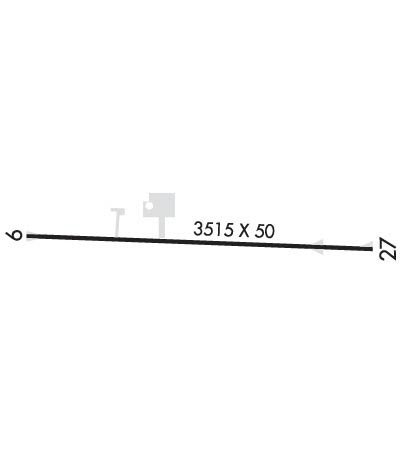
  • Runway Identifications
    Runway Identification: 09/27
    Length: 3515 ft
    Width: 50 ft
    Surface: ASPHALT-GOOD CONDITION
    Edge lights: Medium Intensity

    Treatment: NONE

     Runway: 09   Runway: 27
    Mag heading: 91°Mag heading: 271°
    Rwy Slope: -.07% DownRwy Slope: .07% Up
    Approach: Approach:
    Pattern: Left TrafficPattern: Left Traffic
    Markings: NONPRECISION INSTRUMENTMarkings: NONPRECISION INSTRUMENT
    Marking Condition: GOODMarking Condition: GOOD
    Arresting Dev: Arresting Dev:
    Lat & Long: N3938.1  W09144.0Lat. & Long.: N3938.1  W09143.2
    Elev: 736.6 ft. MSLElev: 734.2 ft. MSL
    TCH: 38 ft. AGLTCH: 39 ft. AGL
    Visual Glide Path: 3.00 degreesVisual Glide Path: 3.00 degrees
    Displaced Threshold: NoDisplaced Threshold: No
    Touchdown Zone: YESTouchdown Zone: YES
    Touchdown Elev.: 737.1 feetTouchdown Elev.: 737.1 feet
    Visual Glide Slope: 2-Light PAPI on LEFT side of RunwayVisual Glide Slope: 2-Light PAPI on LEFT side of Runway
    RVR Equipment: RVR Equipment:
    RVV Equipment: NORVV Equipment: NO
    Approach Lights: Approach Lights:
    REIL: NOREIL: NO
    Centerline Lights: NOCenterline Lights: NO
    Touchdown lights: NOTouchdown lights: NO
    Runway Category: Runway with a Non-precision ApproachRunway Category: Runway with a Non-precision Approach
    Declared Distances: Declared Distances:
    Obstructions: POLEObstructions: TREES
    Marked: NOT Marked/LightedMarked: NOT Marked/Lighted
    Clearance slope: 14:1Clearance slope: 10:1
    Obstruction height: 20 feet AGLObstruction height: 21 feet AGL
    Dist. from runway: 495 feetDist. from runway: 425 feet
    Centerline offset: 145 right of centerlineCenterline offset: 125 feet right of centerline
    Comments: +1-4' FENCE 0-200' FM RY END 120'R.Comments: 1-5 FT FENCE 65-200 FT FM RY END & 120 FT R; 1-5 FT FENCE 0-200 FT FM RY END & 125 FT L.
    C:1/P: