Approach Charts
| FltPlan does not have IFR approach charts available for KK51. |
Current Weather/Notams (Metars, TAFs, Notams, NWS Forecast, PIREPS, and nearby weather)
Customs Information Send updates to Support@FltPlan.com
Customs Not Available
Database effective 04/18/2024
Airport Diagram might not be current.
|
| Facility Name: | MEDICINE LODGE |
| City Name: | MEDICINE LODGE |
| County: | BARBER |
| State abbrev: | KS |
| State Name: | KANSAS |
| | |
| Ownership: | PUBLICLY OWNED |
| Use: | OPEN TO THE PUBLIC |
| Owner's Name: | MEDICINE LODGE |
| Address: | 114 W. 1ST STREET |
| | MEDICINE LODGE, KS 67104 |
| Owner's Phone: | 620-886-3908 |
| | |
| Manager's Name: | JEFF PORTER |
| Address: | 114 W 1ST ST. |
| | MEDICINE LODGE, KS 67104 |
| Phone: | 620-886-3908 |
| | |
| FAA Region: | CENTRAL |
| FAA Field Office: | NONE |
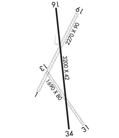
Runway Identifications
Runway Identification: 13/31Length: 1690 ft
Width: 80 ft
Surface: GRASS-GOOD CONDITION
Edge lights: Treatment: NONE
| | Runway: 13 | | Runway: 31 |
| Mag heading: | 138° | Mag heading: | 318° |
| Rwy Slope: | -.65% Down | Rwy Slope: | .65% Up |
| Approach: | | Approach: | |
| Pattern: | Left Traffic | Pattern: | Left Traffic |
| Markings: | | Markings: | |
| Marking Condition: | | Marking Condition: | |
| Arresting Dev: | | Arresting Dev: | |
| Lat & Long: | N3716.0 W09833.0 | Lat. & Long.: | N3715.7 W09832.8 |
| Elev: | 1522.0 ft. MSL | Elev: | 1511.0 ft. MSL |
| TCH: | | TCH: | |
| Visual Glide Path: | | Visual Glide Path: | |
| Displaced Threshold: | No | Displaced Threshold: | No |
| Touchdown Zone: | NO | Touchdown Zone: | NO |
| Touchdown Elev.: | | Touchdown Elev.: | |
| Visual Glide Slope: | | Visual Glide Slope: | |
| RVR Equipment: | | RVR Equipment: | |
| RVV Equipment: | NO | RVV Equipment: | NO |
| Approach Lights: | | Approach Lights: | |
| REIL: | NO | REIL: | NO |
| Centerline Lights: | NO | Centerline Lights: | NO |
| Touchdown lights: | NO | Touchdown lights: | NO |
| Runway Category: | Runway with a Visual Approach | Runway Category: | Runway with a Visual Approach |
| Declared Distances: | | Declared Distances: | |
| Obstructions: | | Obstructions: | FENCE |
| Marked: | | Marked: | NOT Marked/Lighted |
| Clearance slope: | 20:1 | Clearance slope: | |
| Obstruction height: | | Obstruction height: | 6 feet AGL |
| Dist. from runway: | | Dist. from runway: | 0 feet |
| Centerline offset: | | Centerline offset: | |
| Comments: | | Comments: | |
Runway Identification: 16/34Length: 3200 ft
Width: 42 ft
Surface: ASPHALT-GOOD CONDITION
Edge lights: Low IntensityTreatment: NONE
| | Runway: 16 | | Runway: 34 |
| Mag heading: | 167° | Mag heading: | 347° |
| Rwy Slope: | -1.28% Down | Rwy Slope: | 1.28% Up |
| Approach: | | Approach: | |
| Pattern: | Left Traffic | Pattern: | Left Traffic |
| Markings: | BASIC | Markings: | BASIC |
| Marking Condition: | GOOD | Marking Condition: | GOOD |
| Arresting Dev: | | Arresting Dev: | |
| Lat & Long: | N3716.2 W09832.9 | Lat. & Long.: | N3715.7 W09832.8 |
| Elev: | 1549.0 ft. MSL | Elev: | 1508.0 ft. MSL |
| TCH: | | TCH: | |
| Visual Glide Path: | | Visual Glide Path: | |
| Displaced Threshold: | No | Displaced Threshold: | 200 feet |
| Touchdown Zone: | NO | Touchdown Zone: | NO |
| Touchdown Elev.: | | Touchdown Elev.: | |
| Visual Glide Slope: | | Visual Glide Slope: | |
| RVR Equipment: | | RVR Equipment: | |
| RVV Equipment: | NO | RVV Equipment: | NO |
| Approach Lights: | | Approach Lights: | |
| REIL: | NO | REIL: | NO |
| Centerline Lights: | NO | Centerline Lights: | NO |
| Touchdown lights: | NO | Touchdown lights: | NO |
| Runway Category: | Runway with a Visual Approach | Runway Category: | Runway with a Visual Approach |
| Declared Distances: | TORA:3200' TODA:3200' | Declared Distances: | TORA:3200' TODA:3200' |
| Obstructions: | TREE | Obstructions: | |
| Marked: | NOT Marked/Lighted | Marked: | |
| Clearance slope: | 13:1 | Clearance slope: | 20:1 |
| Obstruction height: | 40 feet AGL | Obstruction height: | |
| Dist. from runway: | 745 feet | Dist. from runway: | |
| Centerline offset: | 20 left of centerline | Centerline offset: | |
| Comments: | | Comments: | 5 FT FENCE 160 FT FROM RY END. |

