Approach Charts
FltPlan does not have IFR approach charts available for KK34.
Current Weather/Notams (Metars, TAFs, Notams, NWS Forecast, PIREPS, and nearby weather)
Customs Information Send updates to Support@FltPlan.com
Customs Not Available
Database effective 05/16/2024
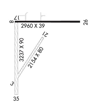
Airport Diagram might not be current. Facility Name: GARDNER MUNI City Name: GARDNER County: JOHNSON State abbrev: KS State Name: KANSAS Ownership: PUBLICLY OWNED Use: OPEN TO THE PUBLIC Owner's Name: CITY OF GARDNER Address: CITY HALL, 120 E MAIN ST. GARDNER, KS 66030 Owner's Phone: 913-856-0914 Manager's Name: KELLEN HEADLEE Address: 120 E. MAIN ST., 31905 W 175 ST GARDNER, KS 66030 Phone: 913-856-0914 FAA Region: CENTRAL FAA Field Office: NONE
Runway Identifications Help
Runway Identification: 03/21 Length: 1871 ftWidth: 60 ftSurface: GRASS-GOOD CONDITIONEdge lights: Treatment: NONE Runway: 03 Runway: 21 Mag heading: 29° Mag heading: 209° Rwy Slope: -.05% Down Rwy Slope: .05% Up Approach: Approach: Pattern: Left Traffic Pattern: Left Traffic Markings: NUMBERS ONLY Markings: NUMBERS ONLY Marking Condition: POOR Marking Condition: POOR Arresting Dev: Arresting Dev: Lat & Long: N3848.2 W09457.5 Lat. & Long.: N3848.5 W09457.3 Elev: 1032.0 ft. MSL Elev: 1031.0 ft. MSL TCH: TCH: Visual Glide Path: Visual Glide Path: Displaced Threshold: No Displaced Threshold: No Touchdown Zone: YES Touchdown Zone: YES Touchdown Elev.: 1032.0 feet Touchdown Elev.: 1032.0 feet Visual Glide Slope: Visual Glide Slope: RVR Equipment: RVR Equipment: RVV Equipment: NO RVV Equipment: NO Approach Lights: Approach Lights: REIL: NO REIL: NO Centerline Lights: NO Centerline Lights: NO Touchdown lights: NO Touchdown lights: NO Runway Category: Runway with a Visual Approach Runway Category: Runway with a Visual Approach Declared Distances: Declared Distances: Obstructions: TREE; +31 FT TREES R EDGE OF RWY APRX 400 FT DOWN RWY. Obstructions: Marked: NOT Marked/Lighted Marked: Clearance slope: 19:1 Clearance slope: 20:1 Obstruction height: 33 feet AGL Obstruction height: Dist. from runway: 627 feet Dist. from runway: Centerline offset: 99 left of centerline Centerline offset: Comments: Comments:
Runway Identification: 08/26 Length: 2399 ftWidth: 36 ftSurface: ASPHALT-FAIR CONDITIONEdge lights: Low Intensity Treatment: NONEWeight: PCN 3 /F/C/Y/U Runway: 08 Runway: 26 Mag heading: 85° Mag heading: 265° Rwy Slope: .15% Up Rwy Slope: -.15% Down Approach: Approach: Pattern: Left Traffic Pattern: Left Traffic Markings: BASIC Markings: BASIC Marking Condition: GOOD Marking Condition: GOOD Arresting Dev: Arresting Dev: Lat & Long: N3848.6 W09457.5 Lat. & Long.: N3848.6 W09457.0 Elev: 1029.7 ft. MSL Elev: 1033.4 ft. MSL TCH: TCH: Visual Glide Path: Visual Glide Path: Displaced Threshold: No Displaced Threshold: No Touchdown Zone: YES Touchdown Zone: YES Touchdown Elev.: 1032.0 feet Touchdown Elev.: 1032.0 feet Visual Glide Slope: Visual Glide Slope: RVR Equipment: RVR Equipment: RVV Equipment: NO RVV Equipment: NO Approach Lights: Approach Lights: REIL: NO REIL: NO Centerline Lights: NO Centerline Lights: NO Touchdown lights: NO Touchdown lights: NO Runway Category: Runway with a Visual Approach Runway Category: Runway with a Visual Approach Declared Distances: Declared Distances: Obstructions: FENCE Obstructions: Marked: NOT Marked/Lighted Marked: Clearance slope: 37:1 Clearance slope: 20:1; DSPLCD THLD APCH RATIO 31:1. Obstruction height: 3 feet AGL Obstruction height: Dist. from runway: 311 feet Dist. from runway: Centerline offset: Centerline offset: Comments: Comments:
Runway Identification: 17/35 Length: 3224 ftWidth: 60 ftSurface: GRASS-GOOD CONDITIONEdge lights: Low Intensity Treatment: NONE Runway: 17 Runway: 35 Mag heading: 175° Mag heading: 355° Rwy Slope: .34% Up Rwy Slope: -.34% Down Approach: Approach: Pattern: Left Traffic Pattern: Left Traffic Markings: NONSTANDARD Markings: NONSTANDARD Marking Condition: GOOD Marking Condition: GOOD Arresting Dev: Arresting Dev: Lat & Long: N3848.6 W09457.5 Lat. & Long.: N3848.1 W09457.5 Elev: 1029.0 ft. MSL Elev: 1040.0 ft. MSL TCH: TCH: Visual Glide Path: Visual Glide Path: Displaced Threshold: No Displaced Threshold: No Touchdown Zone: NO Touchdown Zone: NO Touchdown Elev.: Touchdown Elev.: Visual Glide Slope: Visual Glide Slope: RVR Equipment: RVR Equipment: RVV Equipment: NO RVV Equipment: NO Approach Lights: Approach Lights: REIL: NO REIL: NO Centerline Lights: NO Centerline Lights: NO Touchdown lights: NO Touchdown lights: NO Runway Category: Runway with a Visual Approach Runway Category: Runway with a Visual Approach Declared Distances: Declared Distances: Obstructions: Obstructions: TREES Marked: Marked: NOT Marked/Lighted Clearance slope: 20:1 Clearance slope: 13:1 Obstruction height: Obstruction height: 62 feet AGL Dist. from runway: Dist. from runway: 826 feet Centerline offset: Centerline offset: 92 feet left of centerline Comments: Comments: