Approach Charts
| FltPlan does not have IFR approach charts available for KK19. |
Current Weather/Notams (Metars, TAFs, Notams, NWS Forecast, PIREPS, and nearby weather)
Customs Information Send updates to Support@FltPlan.com
Customs Not Available
Database effective 05/16/2024
Airport Diagram might not be current.
|
| Facility Name: | ALBANY MUNI |
| City Name: | ALBANY |
| County: | GENTRY |
| State abbrev: | MO |
| State Name: | MISSOURI |
| | |
| Ownership: | PUBLICLY OWNED |
| Use: | OPEN TO THE PUBLIC |
| Owner's Name: | CITY OF ALBANY |
| Address: | 106 E CLAY |
| | ALBANY, MO 64402 |
| Owner's Phone: | 660-726-3935 |
| | |
| Manager's Name: | DEREK BROWN; GROUNDS KEEPER. |
| Address: | 106 E. CLAY |
| | ALBANY, MO 64402 |
| Phone: | 660-726-3935 |
| | |
| FAA Region: | CENTRAL |
| FAA Field Office: | NONE |
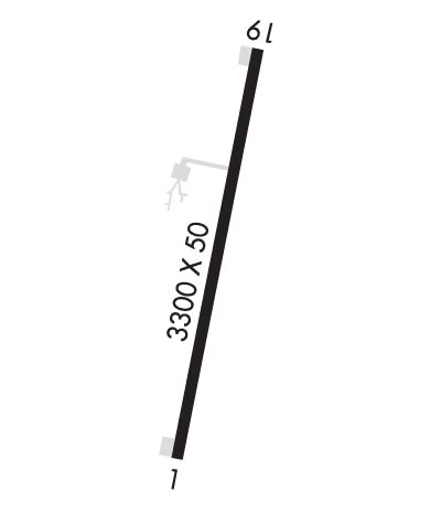
Runway Identifications
Runway Identification: 01/19Length: 3300 ft
Width: 50 ft
Surface: CONCRETE-GOOD CONDITION
Edge lights: Non-Standard Lighting SystemTreatment: NONE
| | Runway: 01 | | Runway: 19 |
| Mag heading: | N/A | Mag heading: | N/A |
| Rwy Slope: | .79% Up | Rwy Slope: | -.79% Down |
| Approach: | | Approach: | |
| Pattern: | Left Traffic | Pattern: | Right Traffic |
| Markings: | BASIC | Markings: | BASIC |
| Marking Condition: | GOOD | Marking Condition: | GOOD |
| Arresting Dev: | | Arresting Dev: | |
| Lat & Long: | N4015.5 W09420.4 | Lat. & Long.: | N4016.0 W09420.3 |
| Elev: | 865.3 ft. MSL | Elev: | 891.3 ft. MSL |
| TCH: | 43 ft. AGL | TCH: | 45 ft. AGL |
| Visual Glide Path: | 3.00 degrees | Visual Glide Path: | 3.00 degrees |
| Displaced Threshold: | No | Displaced Threshold: | No |
| Touchdown Zone: | NO | Touchdown Zone: | NO |
| Touchdown Elev.: | | Touchdown Elev.: | |
| Visual Glide Slope: | 2-Light PAPI on LEFT side of Runway | Visual Glide Slope: | 2-Light PAPI on LEFT side of Runway |
| RVR Equipment: | | RVR Equipment: | |
| RVV Equipment: | NO | RVV Equipment: | NO |
| Approach Lights: | | Approach Lights: | |
| REIL: | NO | REIL: | NO |
| Centerline Lights: | NO | Centerline Lights: | NO |
| Touchdown lights: | NO | Touchdown lights: | NO |
| Runway Category: | Runway with a Visual Approach | Runway Category: | Runway with a Visual Approach |
| Declared Distances: | | Declared Distances: | |
| Obstructions: | TREES | Obstructions: | FENCE |
| Marked: | NOT Marked/Lighted | Marked: | NOT Marked/Lighted |
| Clearance slope: | 14:1 | Clearance slope: | 9:1 |
| Obstruction height: | 44 feet AGL | Obstruction height: | 5 feet AGL |
| Dist. from runway: | 820 feet | Dist. from runway: | 245 feet |
| Centerline offset: | 200 right of centerline | Centerline offset: | 125 feet right of centerline |
| Comments: | +3-15 FT BRUSH, POST, SMALL TREES, FARM ROAD, 95-200 FT FM RWY END, 80-125 FT R. | Comments: | |

