| ||||||||||||||||||||||||||||||||||||||||||||||||||||||||||||||||||||
| ||||||||||||||||||||||||||||||||||||||||||||||||||||||||||||||||||||
| Rwy | Rwy | |||||||
| 3205x60 | 3205' | 3205x60 | 3205' | |||||
| Runway ID | Single Wheel | Double Wheel | Double Tandem Wheel | Dual Double Wheel |
| 14/32 | 15,000 | N/A | N/A | N/A |
| These numbers are Advisory and are not limits. The Airport Manager should have more accurate Weight Limits | ||||
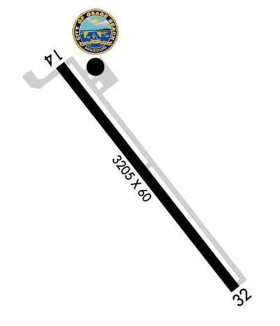 Airport Diagram might not be current. | |
| Facility Name: | GRAND GLAIZE-OSAGE BEACH |
| City Name: | OSAGE BEACH |
| County: | CAMDEN |
| State abbrev: | MO |
| State Name: | MISSOURI |
| Ownership: | PUBLICLY OWNED |
| Use: | OPEN TO THE PUBLIC |
| Owner's Name: | CITY OF OSAGE BEACH |
| Address: | 1000 CITY PARKWAY |
| OSAGE BEACH, MO 65065 | |
| Owner's Phone: | 573-302-2000 |
| Manager's Name: | TY DINSDALE |
| Address: | 1000 CITY PARKWAY |
| OSAGE BEACH, MO 65065 | |
| Phone: | 573-348-4469 |
| FAA Region: | CENTRAL |
| FAA Field Office: | NONE |
| Date | Sunrise | Sunset |
|---|---|---|
| 04/23/24 Tuesday | 6:23 | 19:55 |
| 04/24/24 Wednesday | 6:22 | 19:56 |
| 04/25/24 Thursday | 6:21 | 19:57 |
| 04/26/24 Friday | 6:19 | 19:58 |
| 04/27/24 Saturday | 6:18 | 19:59 |
| 04/28/24 Sunday | 6:17 | 20:00 |
| 04/29/24 Monday | 6:16 | 20:01 |
| 04/30/24 Tuesday | 6:15 | 20:02 |
| 05/01/24 Wednesday | 6:13 | 20:03 |
| 05/02/24 Thursday | 6:12 | 20:03 |
| 05/03/24 Friday | 6:11 | 20:04 |
| 05/04/24 Saturday | 6:10 | 20:05 |
| 05/05/24 Sunday | 6:09 | 20:06 |
| 05/06/24 Monday | 6:08 | 20:07 |
| Airport Attendance Schedule | APR-SEP SAT-THU 0800-1800, APR-SEP FRI 0800-2000, OCT-MAR 7 Days A Week 0800-1800 |
| Airport Status | OPERATIONAL (This Status can change at any time - please check NOTAMS) |
| Airport Lighting Schedule | ACTVT PAPI RWY 32; MIRL RWY 14/32 - CTAF. |
| Airport Storage Available | Tie Downs, Hanger |
| Extra Services Available | NONE |
| Wind Indicator | YES - (lighted) |
| Control Tower | NO |
| CTAF Frequency | 122.800 |
| Unicom Frequency | 122.800 |
| Rotating Beacon Color | WG |
| Segmented Circle | NO |
| Landing Fee | NO |
| Airport Inspected | STATE - performed by STATE AERONAUTICAL PERSONNEL |
| Inspection Date | 05/04/2022 |
| Type of Fuel Available | Grade 100LL, JET A (freeze point -40C) |
| Airframe Repair Service | None |
| Power Plant Repair Service | None |
| Latitude | N3806.6 |
| Longitude | W09240.8 (ESTIMATED) |
| Arpt Elevation | 876ft (SURVEYED) |
| Magnetic Variation | 02E |
| 1 miles SW | of OSAGE BEACH |
| Traffic Pattern Altitude | |
| Sectional Chart | KANSAS CITY |
| Operations (Reported) | Yearly | Avg. Daily |
|---|---|---|
| General Aviation Transient | 2400 | 7 |
| General Aviation Local | 720 | 2 |
| Air Taxi | 30 | 0 |
| Commerical | 0 | 0 |
| Commuter | 0 | 0 |
| Military | 10 | 0 |
| Aircraft based on Field | |
|---|---|
| General Aviation Singles | 9 |
| General Aviation Multi | 1 |
| Jet Aircraft | 0 |
| General Aviation Helicopters | 2 |
| Military Aircraft | 0 |
| Gliders | 0 |
| Ultralights | 0 |
| FSS on field | NO |
| FSS tie-in | COLUMBIA |
| FSS Phone | 1-800-WX-BRIEF |
| Who issues Notams | COU |
| Notam D service at airport | YES |
| ARTCC Name | KANSAS CITY |
| Airport Certification | |
| Aircraft Rescue & Firefighting Index | None |
| Airport of Entry | No |
| Custom Landing Rights | No |
| Joint Civil/Military | No |
| Military Landing rights | YES |
| NATIONAL PLAN OF INTEGRATED AIRPORT SYSTEMS (NPIAS) |
| GRANT AGREEMENTS UNDER FAAP/ADAP/AIP |
| CONVEYANCE UNDER SCETION 16, FEDERAL AIRPORT ACT OF 1946 OR SECTION 23, AIRPORT AND AIRWAY DEVELOPMENT ACT OF 1970 |
| ASSURANCES PURSUANT TO TITLE VI, CIVIL RIGHTS ACT OF 1964 |
| DEER ON AND INVOF RY & TWYS DUSK AND AFT DARK. |
| FOR CD CTC MIZZOU APCH AT 417-868-5620/5619. |
| RWY 14/3 2 RESTRICTED TO ACFT 12,500 LBS MAX GWT OR LESS; PPR FOR ACFT EXCEEDING 12,500 LBS CALL AMGR ON 573-302-2003. |
Airport Communications & Frequencies:
| ||||||||||||||
| Runway: 14 | Runway: 32 | ||
| Mag heading: | 140° | Mag heading: | 320° |
| Rwy Slope: | -.59% Down | Rwy Slope: | .59% Up |
| Approach: | Approach: | ||
| Pattern: | Left Traffic | Pattern: | Left Traffic |
| Markings: | NONPRECISION INSTRUMENT | Markings: | NONPRECISION INSTRUMENT |
| Marking Condition: | GOOD | Marking Condition: | GOOD |
| Arresting Dev: | Arresting Dev: | ||
| Lat & Long: | N3806.8 W09241.0 | Lat. & Long.: | N3806.4 W09240.6 |
| Elev: | 876.3 ft. MSL | Elev: | 857.5 ft. MSL |
| TCH: | TCH: | 46 ft. AGL | |
| Visual Glide Path: | Visual Glide Path: | 3.50 degrees | |
| Displaced Threshold: | No | Displaced Threshold: | No |
| Touchdown Zone: | YES | Touchdown Zone: | YES |
| Touchdown Elev.: | 876.3 feet | Touchdown Elev.: | 875.4 feet |
| Visual Glide Slope: | Visual Glide Slope: | 4-Light PAPI on LEFT side of Runway | |
| RVR Equipment: | RVR Equipment: | ||
| RVV Equipment: | NO | RVV Equipment: | NO |
| Approach Lights: | Approach Lights: | ||
| REIL: | NO | REIL: | NO |
| Centerline Lights: | NO | Centerline Lights: | NO |
| Touchdown lights: | NO | Touchdown lights: | NO |
| Runway Category: | Runway with a Non-precision Approach | Runway Category: | Runway with a Non-precision Approach |
| Declared Distances: | Declared Distances: | ||
| Obstructions: | PLINE | Obstructions: | TREES |
| Marked: | MARKED | Marked: | NOT Marked/Lighted |
| Clearance slope: | 12:1 | Clearance slope: | 3:1 |
| Obstruction height: | 20 feet AGL | Obstruction height: | 34 feet AGL |
| Dist. from runway: | 447 feet | Dist. from runway: | 330 feet |
| Centerline offset: | 290 right of centerline | Centerline offset: | 250 feet right of centerline |
| Comments: | Comments: | BRUSH AND SMALL TREES 10-12 FT TALL, 60-80 FT FROM RWY END, 50 - 70L |