| ||||||||||||||||||||||||||||||||||||||||||||
| ||||||||||||||||||||||||||||||||||||||||||||
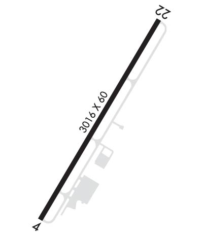
| Rwy | Rwy | |||||||
| 3016x60 | 3016' | 3016x60 | 3016' | |||||
| Runway ID | Single Wheel | Double Wheel | Double Tandem Wheel | Dual Double Wheel |
| 04/22 | 8,000 | N/A | N/A | N/A |
| H1 | N/A | N/A | N/A | N/A |
| These numbers are Advisory and are not limits. The Airport Manager should have more accurate Weight Limits | ||||
 Airport Diagram might not be current. | |
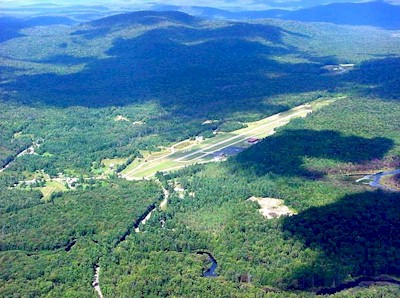
| Facility Name: | PISECO |
| City Name: | PISECO |
| County: | HAMILTON |
| State abbrev: | NY |
| State Name: | NEW YORK |
| Ownership: | PUBLICLY OWNED |
| Use: | OPEN TO THE PUBLIC |
| Owner's Name: | TOWN OF ARIETTA |
| Address: | PO BOX 37 |
| PISECO LAKE, NY 12139 | |
| Owner's Phone: | 518-548-3415 |
| Manager's Name: | TOWN OF ARIETTA (RICHARD WILT) |
| Address: | BOX 37 |
| PISECO LAKE, NY 12139 | |
| Phone: | 518-548-3415; AFTER HRS CALL 518-548-3615 |
| FAA Region: | EASTERN |
| FAA Field Office: | NYC |
| Date | Sunrise | Sunset |
|---|---|---|
| 04/15/24 Monday | 6:14 | 19:42 |
| 04/16/24 Tuesday | 6:13 | 19:43 |
| 04/17/24 Wednesday | 6:11 | 19:45 |
| 04/18/24 Thursday | 6:10 | 19:46 |
| 04/19/24 Friday | 6:08 | 19:47 |
| 04/20/24 Saturday | 6:06 | 19:48 |
| 04/21/24 Sunday | 6:05 | 19:49 |
| 04/22/24 Monday | 6:03 | 19:50 |
| 04/23/24 Tuesday | 6:02 | 19:52 |
| 04/24/24 Wednesday | 6:00 | 19:53 |
| 04/25/24 Thursday | 5:59 | 19:54 |
| 04/26/24 Friday | 5:57 | 19:55 |
| 04/27/24 Saturday | 5:56 | 19:56 |
| 04/28/24 Sunday | 5:54 | 19:57 |
| Airport Attendance Schedule | MAY-OCT SAT-SUN 0900-1700 |
| Airport Status | OPERATIONAL (This Status can change at any time - please check NOTAMS) |
| Airport Lighting Schedule | ACTVT REIL RWY 04 & 22; PAPI RWY 04; MIRL RWY 04/22; HELIPAD PERIMETER LGTS - CTAF. RWY LGTS (ELECTRIC EYE OVER-RIDE). |
| Airport Storage Available | Tie Downs, Hanger |
| Extra Services Available | NONE |
| Wind Indicator | YES - (lighted) |
| Control Tower | NO |
| CTAF Frequency | 122.800 |
| Unicom Frequency | 122.800 |
| Rotating Beacon Color | |
| Segmented Circle | YES |
| Landing Fee | NO |
| Airport Inspected | STATE - performed by STATE AERONAUTICAL PERSONNEL |
| Inspection Date | 08/26/2021 |
| Type of Fuel Available | Grade 100LL |
| Airframe Repair Service | NONE |
| Power Plant Repair Service | NONE |
| Latitude | N4327.2 |
| Longitude | W07430.9 (ESTIMATED) |
| Arpt Elevation | 1703ft (SURVEYED) |
| Magnetic Variation | 14W |
| 1 miles N | of PISECO |
| Traffic Pattern Altitude | |
| Sectional Chart | NEW YORK |
| Operations (Reported) | Yearly | Avg. Daily |
|---|---|---|
| General Aviation Transient | 1050 | 3 |
| General Aviation Local | 2000 | 5 |
| Air Taxi | 0 | 0 |
| Commerical | 0 | 0 |
| Commuter | 0 | 0 |
| Military | 100 | 0 |
| Aircraft based on Field | |
|---|---|
| General Aviation Singles | 2 |
| General Aviation Multi | 0 |
| Jet Aircraft | 0 |
| General Aviation Helicopters | 0 |
| Military Aircraft | 0 |
| Gliders | 0 |
| Ultralights | 0 |
| FSS on field | NO |
| FSS tie-in | BUFFALO |
| FSS Phone | 1-800-WX-BRIEF |
| Who issues Notams | BUF |
| Notam D service at airport | YES |
| ARTCC Name | BOSTON |
| Airport Certification | |
| Aircraft Rescue & Firefighting Index | None |
| Airport of Entry | No |
| Custom Landing Rights | No |
| Joint Civil/Military | No |
| Military Landing rights | YES |
| NATIONAL PLAN OF INTEGRATED AIRPORT SYSTEMS (NPIAS) |
| GRANT AGREEMENTS UNDER FAAP/ADAP/AIP |
| ASSURANCES PURSUANT TO TITLE VI, CIVIL RIGHTS ACT OF 1964 |
| CTN-MODERATE TURBULANCE IN APCH TO RWY 22. |
| FOR CD CTC SYRACUSE APCH AT 315-455-6218. |
| ACFT DEPARTING RY 22 ARE REQUESTED TO MAINTAIN RY HEADING UNTIL PAST ISLAND CHECKPOINT, PRIOR TO MAKING LEFT TURN. ACFT ARRIVING MAINTAIN RGT DOWNWIND HEADING UNTIL PAST ISLAND CHECKPOINT. |
| TWYS HAVE REFLECTIVE MARKERS. |
| EXPECT TURBULENCE & DOWNDRAFTS DURG PERIODS OF STRONG CROSSWINDS. |
| AREA NOT MAINTAINED FOR SKI EQUIPPED ACFT. |
| RWY 04/22 MAY BE UNUSBL DUE TO SNOW ACCUMULATION NOV-APR. CHECK NOTAMS OR CALL 518-548-3415 FOR AIRFIELD CONDITIONS. |
| LARGE BIRDS-DEER-BEARS OCCASIONALLY VCTY OF RWY DURING SUMMER MONTHS. |
Airport Communications & Frequencies:
| |||||||||
| Runway: 04 | Runway: 22 | ||
| Mag heading: | 45° | Mag heading: | 225° |
| Rwy Slope: | .30% Up | Rwy Slope: | -.30% Down |
| Approach: | Approach: | ||
| Pattern: | Right Traffic | Pattern: | Left Traffic |
| Markings: | NONPRECISION INSTRUMENT | Markings: | BASIC |
| Marking Condition: | GOOD | Marking Condition: | GOOD |
| Arresting Dev: | Arresting Dev: | ||
| Lat & Long: | N4327.0 W07431.1 | Lat. & Long.: | N4327.4 W07430.7 |
| Elev: | 1694.0 ft. MSL | Elev: | 1702.9 ft. MSL |
| TCH: | 52 ft. AGL | TCH: | |
| Visual Glide Path: | 3.80 degrees | Visual Glide Path: | |
| Displaced Threshold: | No | Displaced Threshold: | No |
| Touchdown Zone: | YES | Touchdown Zone: | YES |
| Touchdown Elev.: | 1703.2 feet | Touchdown Elev.: | 1703.2 feet |
| Visual Glide Slope: | 2-Light PAPI on LEFT side of Runway; RWY 04 PAPI UNUSBL 9 DEG RIGHT OF CTRLN. | Visual Glide Slope: | |
| RVR Equipment: | RVR Equipment: | ||
| RVV Equipment: | NO | RVV Equipment: | NO |
| Approach Lights: | Approach Lights: | ||
| REIL: | YES | REIL: | YES |
| Centerline Lights: | NO | Centerline Lights: | NO |
| Touchdown lights: | NO | Touchdown lights: | NO |
| Runway Category: | Runway with a Non-precision Approach | Runway Category: | Runway with a Visual Approach |
| Declared Distances: | Declared Distances: | ||
| Obstructions: | TREES | Obstructions: | TREES |
| Marked: | NOT Marked/Lighted | Marked: | NOT Marked/Lighted |
| Clearance slope: | 4:1 | Clearance slope: | 3:1 |
| Obstruction height: | 49 feet AGL | Obstruction height: | 104 feet AGL |
| Dist. from runway: | 421 feet | Dist. from runway: | 582 feet |
| Centerline offset: | 179 right of centerline | Centerline offset: | 268 feet right of centerline |
| Comments: | ROADS PARALLEL TO RWY 124 FT LT AND 215 FT RT. | Comments: | RWY 22 +80 FT TREES, 0-200 FT FROM RWY, 243 FT LT AND RT OF CENTERLINE. |