Current Weather/Notams (Metars, TAFs, Notams, NWS Forecast, PIREPS, and nearby weather)
Customs Information Send updates to Support@FltPlan.com
Customs Not Available
Database effective 05/16/2024
Airport Diagram might not be current. Facility Name: CHARLESTON EXEC City Name: CHARLESTON County: CHARLESTON State abbrev: SC State Name: SOUTH CAROLINA Ownership: PUBLICLY OWNED Use: OPEN TO THE PUBLIC Owner's Name: CHARLESTON CO AVN AUTHORITY Address: 5500 INTL BLVD, # 101 CHARLESTON, SC 29418-6911 Owner's Phone: 843-767-7000 Manager's Name: ELLIOTT SUMMEY Address: 5500 INTERNATIONAL BLVD, #101 CHARLESTON, SC 29418 Phone: 843-767-7000 FAA Region: SOUTHERN FAA Field Office: ATL
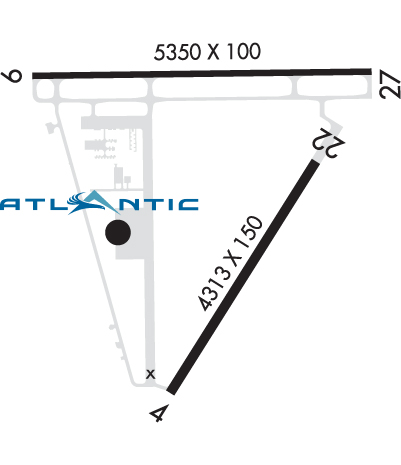
Runway Identifications Help
Runway Identification: 04/22 Length: 4313 ftWidth: 150 ftSurface: CONCRETE-GOOD CONDITIONEdge lights: Medium Intensity Treatment: NONE Runway: 04 Runway: 22 Mag heading: 37° Mag heading: 217° Rwy Slope: .03% Up Rwy Slope: -.03% Down Approach: Approach: Pattern: Left Traffic Pattern: Left Traffic Markings: NONPRECISION INSTRUMENT Markings: BASIC Marking Condition: GOOD Marking Condition: GOOD Arresting Dev: Arresting Dev: Lat & Long: N3241.5 W08000.3 Lat. & Long.: N3242.1 W07959.9 Elev: 9.8 ft. MSL Elev: 11.1 ft. MSL TCH: TCH: Visual Glide Path: Visual Glide Path: Displaced Threshold: No Displaced Threshold: No Touchdown Zone: YES Touchdown Zone: YES Touchdown Elev.: 13.4 feet Touchdown Elev.: 13.4 feet Visual Glide Slope: Visual Glide Slope: RVR Equipment: RVR Equipment: RVV Equipment: NO RVV Equipment: NO Approach Lights: Approach Lights: REIL: NO REIL: NO Centerline Lights: NO Centerline Lights: NO Touchdown lights: NO Touchdown lights: NO Runway Category: Runway with a Non-precision Approach having visibility minimums greater than 3/4 mile Runway Category: Runway with a Visual Approach Declared Distances: Declared Distances: Obstructions: TREE Obstructions: Marked: NOT Marked/Lighted Marked: Clearance slope: 13:1 Clearance slope: 20:1 Obstruction height: 8 feet AGL Obstruction height: Dist. from runway: 310 feet Dist. from runway: Centerline offset: 149 right of centerline Centerline offset: Comments: Comments:
Runway Identification: 09/27 Length: 5350 ftWidth: 100 ftSurface: CONCRETEEdge lights: High Intensity Treatment: GROOVED Runway: 09 Runway: 27 Mag heading: 94° Mag heading: 274° Rwy Slope: -.14% Down Rwy Slope: .14% Up Approach: ILS/DME Approach: Pattern: Left Traffic Pattern: Left Traffic Markings: PRECISION INSTRUMENT Markings: NONPRECISION INSTRUMENT Marking Condition: GOOD Marking Condition: GOOD Arresting Dev: Arresting Dev: Lat & Long: N3242.3 W08000.8 Lat. & Long.: N3242.3 W07959.7 Elev: 18.6 ft. MSL Elev: 11.1 ft. MSL TCH: 50 ft. AGL TCH: 44 ft. AGL Visual Glide Path: 3.00 degrees Visual Glide Path: 3.00 degrees Displaced Threshold: No Displaced Threshold: 350 feet Touchdown Zone: YES Touchdown Zone: YES Touchdown Elev.: 18.6 feet Touchdown Elev.: 15.4 feet Visual Glide Slope: 4-Light PAPI on LEFT side of Runway Visual Glide Slope: 4-Light PAPI on RIGHT side of Runway RVR Equipment: RVR Equipment: RVV Equipment: NO RVV Equipment: NO Approach Lights: Approach Lights: REIL: YES REIL: YES Centerline Lights: NO Centerline Lights: NO Touchdown lights: NO Touchdown lights: NO Runway Category: Precision Instrument Runway Runway Category: Runway with a Non-precision Approach having visibility minimums greater than 3/4 mile Declared Distances: Declared Distances: Obstructions: TREE Obstructions: BRUSH Marked: NOT Marked/Lighted Marked: NOT Marked/Lighted Clearance slope: 35:1 Clearance slope: 14:1; APPROACH SLOPE TO DISPLACED THR. IS 50:1. Obstruction height: 112 feet AGL Obstruction height: 16 feet AGL Dist. from runway: 4162 feet Dist. from runway: 438 feet Centerline offset: 517 right of centerline Centerline offset: 250 feet right of centerline Comments: Comments: