Click here for more info on on SMS!

KJXN

JACKSON COUNTY-REYNOLDS FIELD
JACKSON
MI
Time Zone: Eastern
Lat: N 4215.6
Long: W 08427.7
Elev: 1001
Var: +07
Longest Runway: 5351
Clr Del: 121.9
Dept. ATIS: 125.72
Arr. ATIS: 125.72
AWOS: 125.72
Ground: 121.9
Tower: 128.47

FBO & Flight Services info for KJXN

FBOs: Update your Fuel Prices
Our line service provides Phillips66 brand fuel at your request. Both 100LL & Jet is available for purchase. Catering, Charter, GPU, Refreshments, Flight Instruction.
Ph: 517-787-2460 Fax: 517-787-0299 Freq: 122.95WebsiteE-Mail
Service
Jet
100LL
SAF
MoGas
Fuel Avail: ~~PILOTS CALL FOR FUEL PRICES
Full        Last Update: 04/20/2024 05:45:14

Self        
Misc. Info: Address: 3606 WILDWOOD AVE   JACKSON, MI 49202

ASOSPh: 517-768-7506
-
Freq: 125.72  
If you are an FBO, call 1-203-262-1700 to update your info or email: FltPlan.Advertising@garmin.com
Advertise your FBO on FltPlan.com

Runway & Approach Info for KJXN
Rwy
Length
Land Dist**
Approach*
  Rwy
Length
Land Dist**
Approach*
07
5351x100  5351'          
 
  
25
  5351x100  5351'          
ILS
 109.10 - 254°  
14
4000x100  4000'          
 
  
32
  4000x100  4000'          
 
 * only ILS, LOC, LDA, and SDF approaches to a specific runway are shown
** For any Declared Landing Distance Available, please see A/FD or Approach plates
Runway Weight Capability (lbs.) Help
Runway IDSingle WheelDouble WheelDouble Tandem WheelDual Double Wheel
07/2576,000100,000180,000N/A
14/3242,00062,000115,000N/A
These numbers are Advisory and are not limits.   The Airport Manager should have more accurate Weight Limits
Approach Charts
Approaches    
Current Weather/Notams
Customs Information Send updates to Support@FltPlan.com
Customs Not Available
Database effective 04/18/2024
Airport Diagram of KJXN
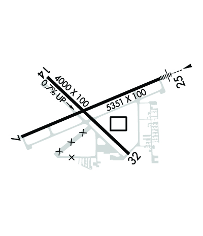
Airport Diagram might not be current.

Facility Name: JACKSON COUNTY/REYNOLDS FLD
City Name: JACKSON
County: JACKSON
State abbrev: MI
State Name: MICHIGAN
   
Ownership: PUBLICLY OWNED
Use: OPEN TO THE PUBLIC
Owner's Name: JACKSON COUNTY
Address: 120 W MICHIGAN AVE, JACKSON CO TOWER BLDG 5TH FL
 JACKSON, MI 49201-1338
Owner's Phone: 517-788-4335
  
Manager's Name: JUAN ZAPATA
Address: 3606 WILDWOOD AVE
 JACKSON, MI 49202-1864
Phone: 517-788-4225
   
FAA Region: GREAT LAKES
FAA Field Office: DET


Sunrise / Sunset times for JACKSON COUNTY/REYNOLDS FLD

DateSunriseSunset
04/19/24 Friday6:5020:25
04/20/24 Saturday6:4820:26
04/21/24 Sunday6:4720:27
04/22/24 Monday6:4520:28
04/23/24 Tuesday6:4420:29
04/24/24 Wednesday6:4220:30
04/25/24 Thursday6:4120:31
04/26/24 Friday6:3920:33
04/27/24 Saturday6:3820:34
04/28/24 Sunday6:3620:35
04/29/24 Monday6:3520:36
04/30/24 Tuesday6:3420:37
05/01/24 Wednesday6:3220:38
05/02/24 Thursday6:3120:39

Airport Facilities

Airport Attendance ScheduleMON-FRI 0800-1700, SAT-SUN 0800-1500
Airport Status OPERATIONAL (This Status can change at any time - please check NOTAMS)
Airport Lighting ScheduleWHEN ATCT CLSD ACTVT MALSR RWY 25; REIL RWY 07 & 32; PAPI RWY 07, 25, 14 & 32; HIRL RWY 07/25; MIRL RWY 14/32 - CTAF.
Airport Storage AvailableTie Downs, Hanger
Extra Services AvailableFlight Instruction
Wind IndicatorYES - (lighted)
Control TowerYES
CTAF Frequency128.475
Unicom Frequency122.950
Rotating Beacon ColorWG
Segmented CircleYES
Landing FeeNO

Airport Inspection Data

Airport InspectedSTATE - performed by STATE AERONAUTICAL PERSONNEL
Inspection Date05/26/2022

Airport Services

Type of Fuel AvailableGrade 100LL, JET A; -10100LL & JET A+ AVBL SELF SVC ON MAIN RAMP.
Airframe Repair ServiceMAJOR
Power Plant Repair ServiceMAJOR

Geographic Data

LatitudeN4215.6
LongitudeW08427.7 (ESTIMATED)
Arpt Elevation1000ft (SURVEYED)
Magnetic Variation07W
2 miles Wof JACKSON
Traffic Pattern Altitude
Sectional ChartDETROIT

Aircraft Data

Operations (Reported)YearlyAvg. Daily
General Aviation Transient 1651445
General Aviation Local 955926
Air Taxi 00
Commerical 00
Commuter 00
Military 2061
Aircraft based on Field
General Aviation Singles 67
General Aviation Multi 15
Jet Aircraft 3
General Aviation Helicopters 1
Military Aircraft 0
Gliders 1
Ultralights 0

FAA Services

FSS on field NO
FSS tie-in LANSING
FSS Phone 1-800-WX-BRIEF
Who issues Notams JXN
Notam D service at airport YES
ARTCC Name CLEVELAND

Federal Status

Airport Certification
Aircraft Rescue & Firefighting IndexNone
Airport of EntryNo
Custom Landing RightsNo
Joint Civil/MilitaryNo
Military Landing rightsYES

Federal Agreements

NATIONAL PLAN OF INTEGRATED AIRPORT SYSTEMS (NPIAS)
GRANT AGREEMENTS UNDER FAAP/ADAP/AIP
ASSURANCES PURSUANT TO TITLE VI, CIVIL RIGHTS ACT OF 1964

Remarks

DEER & LRG BIRDS ON & INVOF ARPT.
LOW ALT HEL OPS PROHIBITED INVOF PRISON 4 MI NE.
WINTER FLD CONDS UNMON WHEN ATCT CLSD.
ACFT TAXIING UP TWY D COULD POSSLY MISS THE TURN FOR TWY A & VIOLATE THE SAFETY ZONE FOR RWY 07/25.
FOR CD WHEN ATCT CLSD CTC GREAT LAKES APCH AT 269-459-3345, WHEN APCH CLSD CTC CLEVELAND ARTCC AT 440-774-0224/0490.
Airport Communications & Frequencies:
ATIS Frequencies:   Hours(local) of Operation: CONTINUOUS
125.725
JACKSON Tower Frequencies:   Hours(local) of operation: 0700-2100   
128.475
257.8
JACKSON Ground Frequencies:
121.9
Clearance Delivery Frequencies:
121.9
Emergency Frequencies:
121.5
243.0
CTAF Frequency:
128.475
Unicom Frequency:
122.950
Remarks
  • APCH/DEP SVC PRVDD BY CLEVELAND ARTCC (ZOB) ON FREQS 120.45/360.7 (LITCHFIELD RCAG) WHEN GREAT LAKES APCH CTL CLSD.
  • GREAT LAKES Primary Approach Frequencies:  
    127.3
    335.575
    GREAT LAKES Primary Departure Frequencies:  
    127.3
    335.575
    Runway Identifications
    Runway Identification: 07/25
    Length: 5351 ft
    Width: 100 ft
    Surface: ASPHALT
    Edge lights: High Intensity

    Treatment: GROOVED
    Weight: PCN 30 /F/C/X/U

     Runway: 07   Runway: 25
    Mag heading: 74°Mag heading: 254°
    Rwy Slope: .17% UpRwy Slope: -.17% Down
    Approach: Approach: ILS
    Pattern: Left TrafficPattern: Left Traffic
    Markings: PRECISION INSTRUMENTMarkings: PRECISION INSTRUMENT
    Marking Condition: GOODMarking Condition: GOOD
    Arresting Dev: Arresting Dev:
    Lat & Long: N4215.5  W08428.3Lat. & Long.: N4215.8  W08427.2
    Elev: 985.0 ft. MSLElev: 993.9 ft. MSL
    TCH: 37 ft. AGLTCH: 45 ft. AGL
    Visual Glide Path: 3.00 degreesVisual Glide Path: 3.00 degrees
    Displaced Threshold: NoDisplaced Threshold: No
    Touchdown Zone: YESTouchdown Zone: YES
    Touchdown Elev.: 993.0 feetTouchdown Elev.: 995.5 feet
    Visual Glide Slope: 4-Light PAPI on LEFT side of RunwayVisual Glide Slope: 4-Light PAPI on LEFT side of Runway
    RVR Equipment: RVR Equipment:
    RVV Equipment: NORVV Equipment: NO
    Approach Lights: Approach Lights: MALSR - 1,400 foot medium intensity approach lighting system with runway alignment indicator lights
    REIL: YESREIL: NO
    Centerline Lights: NOCenterline Lights: NO
    Touchdown lights: NOTouchdown lights: NO
    Runway Category: Runway with a Non-precision Approach having visibility minimums greater than 3/4 mileRunway Category: Precision Instrument Runway
    Declared Distances: Declared Distances:
    Obstructions: PLINEObstructions: TREES
    Marked: NOT Marked/LightedMarked: NOT Marked/Lighted
    Clearance slope: 19:1Clearance slope: 27:1
    Obstruction height: 72 feet AGLObstruction height: 94 feet AGL
    Dist. from runway: 1613 feetDist. from runway: 2758 feet
    Centerline offset: 660 right of centerlineCenterline offset: 773 feet left of centerline
    Comments: Comments:
    Runway Identification: 14/32
    Length: 4000 ft
    Width: 100 ft
    Surface: ASPHALT-GOOD CONDITION
    Edge lights: Medium Intensity

    Treatment: GROOVED
    Weight: PCN 16 /F/C/X/U

     Runway: 14   Runway: 32
    Mag heading: 140°Mag heading: 320°
    Rwy Slope: .71% UpRwy Slope: -.71% Down
    Approach: Approach:
    Pattern: Left TrafficPattern: Left Traffic
    Markings: NONPRECISION INSTRUMENTMarkings: NONPRECISION INSTRUMENT
    Marking Condition: GOODMarking Condition: GOOD
    Arresting Dev: Arresting Dev:
    Lat & Long: N4215.8  W08428.1Lat. & Long.: N4215.4  W08427.4
    Elev: 972.1 ft. MSLElev: 1000.6 ft. MSL
    TCH: 25 ft. AGLTCH: 31 ft. AGL
    Visual Glide Path: 3.00 degreesVisual Glide Path: 3.50 degrees
    Displaced Threshold: NoDisplaced Threshold: No
    Touchdown Zone: YESTouchdown Zone: YES
    Touchdown Elev.: 995.7 feetTouchdown Elev.: 1000.8 feet
    Visual Glide Slope: 4-Light PAPI on LEFT side of RunwayVisual Glide Slope: 4-Light PAPI on LEFT side of Runway
    RVR Equipment: RVR Equipment:
    RVV Equipment: NORVV Equipment: NO
    Approach Lights: Approach Lights:
    REIL: NOREIL: YES
    Centerline Lights: NOCenterline Lights: NO
    Touchdown lights: NOTouchdown lights: NO
    Runway Category: Runway with a Non-precision ApproachRunway Category: Runway with a Non-precision Approach
    Declared Distances: Declared Distances:
    Obstructions: FENCEObstructions:
    Marked: NOT Marked/LightedMarked:
    Clearance slope: 25:1Clearance slope: 20:1
    Obstruction height: 10 feet AGLObstruction height:
    Dist. from runway: 452 feetDist. from runway:
    Centerline offset: 250 right of centerlineCenterline offset:
    Comments: Comments:
    C:13/P: