KJWN

JOHN C TUNE
NASHVILLE
TN
Time Zone: Central
Lat: N 3611.0
Long: W 08653.2
Elev: 501
Var: +03
Longest Runway: 6001
Clr Del: 124.55
Dept. ATIS: 127.07
Arr. ATIS: 127.07
AWOS: 127.07
Ground: 121.7
Tower: 119.45

FBO & Flight Services info for KJWN

FBOs: Update your Fuel Prices

CONTOUR FLIGHTPh: 615-350-5000 Fax: 615-350-5018 Freq: 122.85
Service
Jet
100LL
SAF
MoGas
Fuel Avail: 24/7 Fueling
Full6.297.45    Last Update: 04/08/2024 09:36

Self  6.45    
 Address: 110 TUNE AIRPORT DR   NASHVILLE, TN 37209
AWOSPh: 615-350-6222
-
Freq: 127.07  
If you are an FBO, call 1-203-262-1700 to update your info or email: FltPlan.Advertising@garmin.com
Advertise your FBO on FltPlan.com
FBOs at nearby airports who want your business:
KXNX


  click here  
Located in Sumner County, 30 minutes northeast of downtown Nashville, Jet Access is a new alternate to the ever booming market of Middle Tennessee. Out of the hustle and bustle of Nashville International and John Tune Airport, Jet Access provides a convenience that its competition cannot. It is also the best valued FBO in the Nashville market.
Ph: 615-451-1490 WebsiteE-MailFax: 615-451-1464 Freq: 123.05

Runway & Approach Info for KJWN
Rwy
Length
Land Dist**
Approach*
  Rwy
Length
Land Dist**
Approach*
02
6001x100  6001'          
 
  
20
  6001x100  6001'          
ILS/DME
 110.30 - 197°  
 * only ILS, LOC, LDA, and SDF approaches to a specific runway are shown
** For any Declared Landing Distance Available, please see A/FD or Approach plates
Runway Weight Capability (lbs.) Help
Runway IDSingle WheelDouble WheelDouble Tandem WheelDual Double Wheel
02/2035,00097,000N/AN/A
These numbers are Advisory and are not limits.   The Airport Manager should have more accurate Weight Limits
Approach Charts
Approaches    
Current Weather/Notams
Customs Information Send updates to Support@FltPlan.com
Customs Not Available
Database effective 05/16/2024
Airport Diagram of KJWN
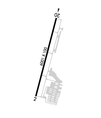
Airport Diagram might not be current.

Facility Name: JOHN C TUNE
City Name: NASHVILLE
County: DAVIDSON
State abbrev: TN
State Name: TENNESSEE
   
Ownership: PUBLICLY OWNED
Use: OPEN TO THE PUBLIC
Owner's Name: METRO NASHVILLE APT AUTHORITY
Address: ONE TERMINAL DR.
 NASHVILLE, TN 37214
Owner's Phone: 615-275-1600
  
Manager's Name: CHRISTOPHER B. DAVIDSON
Address: 110 TUNE AIRPORT DRIVE
 NASHVILLE, TN 37209
Phone: 615-275-1783; 615-347-4196
   
FAA Region: SOUTHERN
FAA Field Office: MEM


Sunrise / Sunset times for JOHN C TUNE

DateSunriseSunset
04/22/24 Monday6:0419:28
04/23/24 Tuesday6:0319:29
04/24/24 Wednesday6:0219:30
04/25/24 Thursday6:0119:31
04/26/24 Friday5:5919:31
04/27/24 Saturday5:5819:32
04/28/24 Sunday5:5719:33
04/29/24 Monday5:5619:34
04/30/24 Tuesday5:5519:35
05/01/24 Wednesday5:5419:36
05/02/24 Thursday5:5319:37
05/03/24 Friday5:5219:37
05/04/24 Saturday5:5119:38
05/05/24 Sunday5:5019:39

Airport Facilities

Airport Attendance ScheduleCONTINUOUS
Airport Status OPERATIONAL (This Status can change at any time - please check NOTAMS)
Airport Lighting ScheduleWHEN ATCT CLSD ACTVT REIL RWY 02 & 20; PAPI RWY 02 & 20; MIRL RWY 02/20 - CTAF.
Airport Storage AvailableTie Downs, Hanger
Extra Services AvailableAvionics, Charter, Flight Instruction, Aircraft Rental, Aircraft Sales
Wind IndicatorYES - (lighted)
Control TowerYES
CTAF Frequency119.450
Unicom Frequency122.700
Rotating Beacon ColorWG
Segmented CircleYES
Landing Fee

Airport Inspection Data

Airport InspectedSTATE - performed by STATE AERONAUTICAL PERSONNEL
Inspection Date08/02/2023

Airport Services

Type of Fuel AvailableGrade 100LL, JET A
Airframe Repair ServiceMAJOR
Power Plant Repair ServiceMAJOR

Geographic Data

LatitudeN3611.0
LongitudeW08653.2 (ESTIMATED)
Arpt Elevation501ft (SURVEYED)
Magnetic Variation03W
1 miles NWof NASHVILLE
Traffic Pattern Altitude
Sectional ChartST LOUIS

Aircraft Data

Operations (Reported)YearlyAvg. Daily
General Aviation Transient 3500096
General Aviation Local 2600071
Air Taxi 25007
Commerical 00
Commuter 00
Military 5001
Aircraft based on Field
General Aviation Singles 136
General Aviation Multi 26
Jet Aircraft 17
General Aviation Helicopters 11
Military Aircraft 0
Gliders 0
Ultralights 0

FAA Services

FSS on field NO
FSS tie-in NASHVILLE
FSS Phone 1-800-WX-BRIEF
Who issues Notams BNA
Notam D service at airport YES
ARTCC Name MEMPHIS

Federal Status

Airport Certification
Aircraft Rescue & Firefighting IndexNone
Airport of EntryNo
Custom Landing RightsNo
Joint Civil/MilitaryNo
Military Landing rightsNo

Federal Agreements

NATIONAL PLAN OF INTEGRATED AIRPORT SYSTEMS (NPIAS)
GRANT AGREEMENTS UNDER FAAP/ADAP/AIP
ASSURANCES PURSUANT TO TITLE VI, CIVIL RIGHTS ACT OF 1964

Remarks

BIRDS & DEER INVOF ARPT.
BLEEDOVER OCR ALL FREQS 1.75 NM NORTH OF RWY.
WHEN ATCT CLSD FOR CD CTC NASHVILLE APCH ON 124.55, IF UNABLE CALL 615-695-4524.
RWY 02/2 0 RWY 20 CALM WIND RWY.
Airport Communications & Frequencies:
ATIS Frequencies:   Hours(local) of Operation: CONTINUOUS
127.075
JOHN TUNE Tower Frequencies:   Hours(local) of operation: 0600-2000   
119.45
JOHN TUNE Ground Frequencies:
121.7
Clearance Delivery Frequencies:
121.7
124.55 WHEN TWR CLSD
CTAF Frequency:
119.450
Unicom Frequency:
122.700
NASHVILLE Primary Approach Frequencies:  
119.35
372.0
NASHVILLE Primary Departure Frequencies:  
119.35
372.0
Runway Identifications
Runway Identification: 02/20
Length: 6001 ft
Width: 100 ft
Surface: ASPHALT-GOOD CONDITION
Edge lights: Medium Intensity

Treatment: GROOVED

 Runway: 02   Runway: 20
Mag heading: 18°Mag heading: 198°
Rwy Slope: .71% UpRwy Slope: -.71% Down
Approach: Approach: ILS/DME
Pattern: Left TrafficPattern: Right Traffic
Markings: NONPRECISION INSTRUMENTMarkings: PRECISION INSTRUMENT
Marking Condition: GOODMarking Condition: GOOD
Arresting Dev: Arresting Dev:
Lat & Long: N3610.5  W08653.3Lat. & Long.: N3611.5  W08653.0
Elev: 458.6 ft. MSLElev: 501.0 ft. MSL
TCH: 40 ft. AGLTCH: 40 ft. AGL
Visual Glide Path: 3.00 degreesVisual Glide Path: 3.00 degrees
Displaced Threshold: NoDisplaced Threshold: No
Touchdown Zone: YESTouchdown Zone: YES
Touchdown Elev.: 483.6 feetTouchdown Elev.: 501.0 feet
Visual Glide Slope: 4-Light PAPI on LEFT side of RunwayVisual Glide Slope: 4-Light PAPI on LEFT side of Runway
RVR Equipment: RVR Equipment:
RVV Equipment: NORVV Equipment: NO
Approach Lights: Approach Lights:
REIL: YESREIL: YES
Centerline Lights: NOCenterline Lights: NO
Touchdown lights: NOTouchdown lights: NO
Runway Category: Runway with a Non-precision Approach having visibility minimums greater than 3/4 mileRunway Category: Precision Instrument Runway
Declared Distances: TORA:6001' TODA:6001' ASDA:6001' LDA:6001'Declared Distances: TORA:6001' TODA:6001' ASDA:6001' LDA:6001'
Obstructions: TREEObstructions: TREE
Marked: NOT Marked/LightedMarked: NOT Marked/Lighted
Clearance slope: 27:1Clearance slope: 31:1
Obstruction height: 49 feet AGLObstruction height: 63 feet AGL
Dist. from runway: 1545 feetDist. from runway: 2166 feet
Centerline offset: 348 right of centerlineCenterline offset: 440 feet right of centerline
Comments: Comments:
C:187/P: