Click here for more info on on SMS!

KJVY

CLARK RGNL
JEFFERSONVILLE
IN
Time Zone: Eastern
Lat: N 3822.0
Long: W 08544.3
Elev: 478
Var: +02
Longest Runway: 7000
Clr Del: 118.05
AWOS: 118.57
CTAF: 122.7

FBO & Flight Services info for KJVY

FBOs: Update your Fuel Prices

  click here  
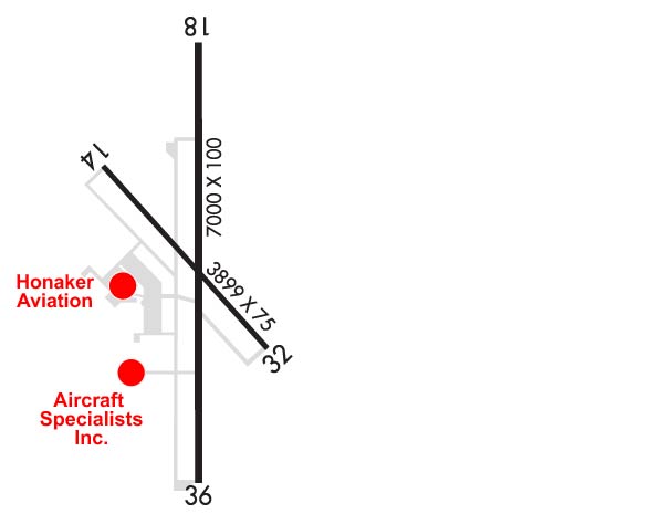
Comprehensive FBO services located 7 miles North of downtown Louisville, KY. Aircraft Specialists is an experienced provider of FBO services with a commitment to excellence. We offer a range of services including, full-service Jet A and 100LL, self-serve 100LL, a part 145 repair station which includes avionics and propellor services.

Preferred FBO for the Kentucky Derby
Ph: 800-356-3723 Fax: 812-246-4365 Freq: 128.90WebsiteE-Mail
                   
Service
Jet
100LL
SAF
MoGas
Fuel Avail: 0600-2200 EDT - Call out available by request
Full7.307.40    Last Update: 04/09/2024 08:53
PRICES GUARANTEED by FBO. *
*Discounts available with qty purchases!
Self  6.60    
Misc. Info: Louisville's Friendliest FBO only minutes from downtown.Address: 6005 PROPELLER LANE   SELLERSBURG, IN 47172

  click here  
Located 10 mi from downtown Louisville, Honaker Aviation is the best alternative to KSDF & KLOU. Over 60,000 sq ft of hangar space & 3,000 sq ft of lobby space make it the Best FBO. Largest pilot lounge in the area featuring free fountain drinks, flat screens, & wifi. We put the service back into the meaning of Full Service FBO. Concierge services can provide hotel rooms, transportation & more.
Ph: 812-246-5491 Fax: 812-246-3819 Freq: 129.27WebsiteE-Mail
                     
Service
Jet
100LL
SAF
MoGas
Fuel Avail: 24/7
Full7.207.20    Last Update: 04/02/2024 09:12

Self        
Misc. Info: Quantity Discounts Available. Hotel Discounts Available. Best Pilot Lounge in Louisville Area.Address: 7001 AIRPORT ROAD   SELLERSBURG, IN 47172

AWOSPh: 812-246-1278
-
Freq: 118.57  
If you are an FBO, call 1-203-262-1700 to update your info or email: FltPlan.Advertising@garmin.com
Advertise your FBO on FltPlan.com

Runway & Approach Info for KJVY
Rwy
Length
Land Dist**
Approach*
  Rwy
Length
Land Dist**
Approach*
14
3899x75  3899'          
 
  
32
  3899x75  3899'          
 
18
7000x100  7000'          
ILS
 111.70 - 181°  
  
36
  7000x100  7000'          
 
 * only ILS, LOC, LDA, and SDF approaches to a specific runway are shown
** For any Declared Landing Distance Available, please see A/FD or Approach plates
Runway Weight Capability (lbs.) Help
Runway IDSingle WheelDouble WheelDouble Tandem WheelDual Double Wheel
14/3212,000N/AN/AN/A
18/3645,00060,000N/AN/A
These numbers are Advisory and are not limits.   The Airport Manager should have more accurate Weight Limits
Approach Charts
Approaches    
Current Weather/Notams
Customs Information Send updates to Support@FltPlan.com
Customs Not Available
Database effective 04/18/2024
Airport Diagram of KJVY
Airport Diagram might not be current.

Facility Name: CLARK RGNL
City Name: JEFFERSONVILLE
County: CLARK
State abbrev: IN
State Name: INDIANA
   
Ownership: PUBLICLY OWNED
Use: OPEN TO THE PUBLIC
Owner's Name: SOUTH CENTRAL REGIONAL AIRPORT AUTH
Address: 6003 PROPELLER LANE
 SELLERSBURG, IN 47172
Owner's Phone: 812-246-7460
  
Manager's Name: JOHN SECOR
Address: 6003 PROPELLER LANE
 SELLERSBURG, IN 47172
Phone: 812-246-7460
   
FAA Region: GREAT LAKES
FAA Field Office: CHI


Sunrise / Sunset times for CLARK RGNL

DateSunriseSunset
04/18/24 Thursday7:0220:23
04/19/24 Friday7:0020:24
04/20/24 Saturday6:5920:25
04/21/24 Sunday6:5820:26
04/22/24 Monday6:5620:27
04/23/24 Tuesday6:5520:28
04/24/24 Wednesday6:5420:29
04/25/24 Thursday6:5320:30
04/26/24 Friday6:5120:31
04/27/24 Saturday6:5020:31
04/28/24 Sunday6:4920:32
04/29/24 Monday6:4820:33
04/30/24 Tuesday6:4620:34
05/01/24 Wednesday6:4520:35

Airport Facilities

Airport Attendance Schedule7 Days A Week 0600-2300
Airport Status OPERATIONAL (This Status can change at any time - please check NOTAMS)
Airport Lighting ScheduleACTVT MALSR RWY 18; REIL RWY 36; PAPI RWY 18 & 36 - CTAF. MIRL RWY 18/36 OPR DUSK-DAWN. RWY 14/32 LGTS PPR - 812-987-2841.
Airport Storage AvailableTie Downs, Hanger
Extra Services AvailableAir Freight, Cargo Handling, Charter, Flight Instruction, Aircraft Rental, Aircraft Sales
Wind IndicatorYES - (lighted)
Control TowerNO
CTAF Frequency122.700
Unicom Frequency122.700
Rotating Beacon ColorWG
Segmented CircleYES
Landing Fee

Airport Inspection Data

Airport InspectedSTATE - performed by STATE AERONAUTICAL PERSONNEL
Inspection Date04/06/2023

Airport Services

Type of Fuel AvailableGrade 100LL, JET A (freeze point -40C)
Airframe Repair ServiceMAJOR
Power Plant Repair ServiceMAJOR

Geographic Data

LatitudeN3822.0
LongitudeW08544.3 (ESTIMATED)
Arpt Elevation477ft (SURVEYED)
Magnetic Variation02W
5 miles Nof JEFFERSONVILLE
Traffic Pattern Altitude800
Sectional ChartST LOUIS

Aircraft Data

Operations (Reported)YearlyAvg. Daily
General Aviation Transient 2131258
General Aviation Local 1779349
Air Taxi 532515
Commerical 00
Commuter 00
Military 00
Aircraft based on Field
General Aviation Singles 120
General Aviation Multi 14
Jet Aircraft 32
General Aviation Helicopters 4
Military Aircraft 0
Gliders 0
Ultralights 0

FAA Services

FSS on field NO
FSS tie-in TERRE HAUTE
FSS Phone 1-800-WX-BRIEF
Who issues Notams HUF
Notam D service at airport YES
ARTCC Name INDIANAPOLIS

Federal Status

Airport Certification
Aircraft Rescue & Firefighting IndexNone
Airport of EntryNo
Custom Landing RightsNo
Joint Civil/MilitaryNo
Military Landing rightsYES

Federal Agreements

NATIONAL PLAN OF INTEGRATED AIRPORT SYSTEMS (NPIAS)
GRANT AGREEMENTS UNDER FAAP/ADAP/AIP
ASSURANCES PURSUANT TO TITLE VI, CIVIL RIGHTS ACT OF 1964

Remarks

STUDENT ACT & WILDLIFE ON & INVOF ARPT.
LNDG FEE FOR NON BASE ACFT.
EMERG PHONE LCTD N SIDE OF AUTH BLDG - CTAF TO OPEN.
FOR CD CTC LOUISVILLE APCH AT 502-375-7499
Airport Communications & Frequencies:
Clearance Delivery Frequencies:
118.05
CTAF Frequency:
122.700
Unicom Frequency:
122.700
LOUISVILLE Primary Approach Frequencies:  
132.075
327.0
LOUISVILLE Primary Departure Frequencies:  
132.075
327.0
Runway Identifications
Runway Identification: 14/32
Length: 3899 ft
Width: 75 ft
Surface: ASPHALT-GOOD CONDITION
Edge lights: Medium Intensity

Treatment: NONE

 Runway: 14   Runway: 32
Mag heading: 140°Mag heading: 320°
Rwy Slope: -.21% DownRwy Slope: .21% Up
Approach: Approach:
Pattern: Left TrafficPattern: Left Traffic
Markings: BASICMarkings: BASIC
Marking Condition: FAIRMarking Condition: FAIR
Arresting Dev: Arresting Dev:
Lat & Long: N3822.2  W08544.6Lat. & Long.: N3821.8  W08544.0
Elev: 468.8 ft. MSLElev: 460.8 ft. MSL
TCH: 34 ft. AGLTCH: 32 ft. AGL
Visual Glide Path: 3.90 degreesVisual Glide Path: 3.90 degrees
Displaced Threshold: NoDisplaced Threshold: No
Touchdown Zone: YESTouchdown Zone: YES
Touchdown Elev.: 468.8 feetTouchdown Elev.: 461.7 feet
Visual Glide Slope: 2-Light PAPI on LEFT side of RunwayVisual Glide Slope: 2-Light PAPI on LEFT side of Runway
RVR Equipment: RVR Equipment:
RVV Equipment: NORVV Equipment: NO
Approach Lights: Approach Lights:
REIL: YESREIL: YES
Centerline Lights: NOCenterline Lights: NO
Touchdown lights: NOTouchdown lights: NO
Runway Category: Runway with a Visual ApproachRunway Category: Runway with a Visual Approach
Declared Distances: Declared Distances:
Runway Identification: 18/36
Length: 7000 ft
Width: 100 ft
Surface: ASPHALT-GOOD CONDITION
Edge lights: Medium Intensity

Treatment: GROOVED

 Runway: 18   Runway: 36
Mag heading: 182°Mag heading:
Rwy Slope: -.23% DownRwy Slope: .23% Up
Approach: ILSApproach:
Pattern: Left TrafficPattern: Left Traffic
Markings: PRECISION INSTRUMENTMarkings: PRECISION INSTRUMENT
Marking Condition: GOODMarking Condition: GOOD
Arresting Dev: Arresting Dev:
Lat & Long: N3822.6  W08544.3Lat. & Long.: N3821.4  W08544.3
Elev: 477.5 ft. MSLElev: 461.2 ft. MSL
TCH: 50 ft. AGLTCH: 40 ft. AGL
Visual Glide Path: 3.00 degreesVisual Glide Path: 3.00 degrees
Displaced Threshold: NoDisplaced Threshold: No
Touchdown Zone: YESTouchdown Zone: YES
Touchdown Elev.: 477.6 feetTouchdown Elev.: 461.6 feet
Visual Glide Slope: 4-Light PAPI on LEFT side of RunwayVisual Glide Slope: 4-Light PAPI on LEFT side of Runway
RVR Equipment: RVR Equipment:
RVV Equipment: NORVV Equipment: NO
Approach Lights: MALSR - 1,400 foot medium intensity approach lighting system with runway alignment indicator lightsApproach Lights:
REIL: NOREIL: YES
Centerline Lights: NOCenterline Lights: NO
Touchdown lights: NOTouchdown lights: NO
Runway Category: Precision Instrument RunwayRunway Category: Runway with a Visual Approach
Declared Distances: Declared Distances:
Obstructions: PLINEObstructions:
Marked: NOT Marked/LightedMarked:
Clearance slope: 42:1Clearance slope: 20:1
Obstruction height: 70 feet AGLObstruction height:
Dist. from runway: 3150 feetDist. from runway:
Centerline offset: 894 left of centerlineCenterline offset:
Comments: Comments:
C:80/P: