Current Weather/Notams (Metars, TAFs, Notams, NWS Forecast, PIREPS, and nearby weather)
Customs Information Send updates to Support@FltPlan.com
Customs Not Available
Database effective 05/16/2024
Airport Diagram might not be current.
|
| Facility Name: | JOHN BELL WILLIAMS |
| City Name: | RAYMOND |
| County: | HINDS |
| State abbrev: | MS |
| State Name: | MISSISSIPPI |
| | |
| Ownership: | PUBLICLY OWNED |
| Use: | OPEN TO THE PUBLIC |
| Owner's Name: | HINDS COMMUNITY COLLEGE |
| Address: | PO BOX 1265 HCC |
| | RAYMOND, MS 39154 |
| Owner's Phone: | 601-857-3367 |
| | |
| Manager's Name: | MICHELE JACKSON |
| Address: | HINDS COMMUNITY COLLEGE, P.O. BOX 1100 |
| | RAYMOND, MS 39154 |
| Phone: | 601-857-3884 |
| | |
| FAA Region: | SOUTHERN |
| FAA Field Office: | JAN |
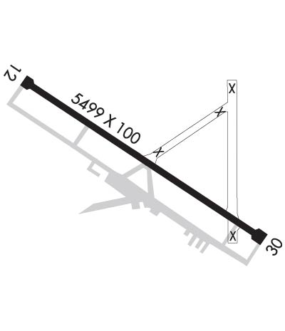
Runway Identifications
Runway Identification: 12/30Length: 5499 ft
Width: 100 ft
Surface: ASPHALT-GOOD CONDITION
Edge lights: Medium IntensityTreatment: RUBBERIZED FRICTION SEAL COAT
| | Runway: 12 | | Runway: 30 |
| Mag heading: | 124° | Mag heading: | 304° |
| Rwy Slope: | .12% Up | Rwy Slope: | -.12% Down |
| Approach: | ILS/DME | Approach: | |
| Pattern: | Left Traffic | Pattern: | Left Traffic |
| Markings: | PRECISION INSTRUMENT | Markings: | NONPRECISION INSTRUMENT |
| Marking Condition: | FAIR | Marking Condition: | FAIR |
| Arresting Dev: | | Arresting Dev: | |
| Lat & Long: | N3218.5 W09025.1 | Lat. & Long.: | N3218.0 W09024.2 |
| Elev: | 240.1 ft. MSL | Elev: | 246.9 ft. MSL |
| TCH: | 38 ft. AGL | TCH: | 50 ft. AGL |
| Visual Glide Path: | 3.00 degrees | Visual Glide Path: | 4.00 degrees |
| Displaced Threshold: | No | Displaced Threshold: | No |
| Touchdown Zone: | YES | Touchdown Zone: | YES |
| Touchdown Elev.: | 241.2 feet | Touchdown Elev.: | 247.0 feet |
| Visual Glide Slope: | 4-Light PAPI on LEFT side of Runway | Visual Glide Slope: | 2-Light PAPI on LEFT side of Runway |
| RVR Equipment: | | RVR Equipment: | |
| RVV Equipment: | NO | RVV Equipment: | NO |
| Approach Lights: | | Approach Lights: | |
| REIL: | YES | REIL: | YES |
| Centerline Lights: | NO | Centerline Lights: | NO |
| Touchdown lights: | NO | Touchdown lights: | NO |
| Runway Category: | Precision Instrument Runway | Runway Category: | Runway with a Non-precision Approach having visibility minimums greater than 3/4 mile |
| Declared Distances: | | Declared Distances: | |
| Obstructions: | | Obstructions: | TREES |
| Marked: | | Marked: | NOT Marked/Lighted |
| Clearance slope: | 50:1 | Clearance slope: | 13:1 |
| Obstruction height: | | Obstruction height: | 80 feet AGL |
| Dist. from runway: | | Dist. from runway: | 1250 feet |
| Centerline offset: | | Centerline offset: | B |
| Comments: | | Comments: | |

