Current Weather/Notams (Metars, TAFs, Notams, NWS Forecast, PIREPS, and nearby weather)
Customs Information Send updates to Support@FltPlan.com
Customs Not Available
Database effective 04/18/2024
Airport Diagram might not be current.
|
| Facility Name: | SOUTHERN WISCONSIN RGNL |
| City Name: | JANESVILLE |
| County: | ROCK |
| State abbrev: | WI |
| State Name: | WISCONSIN |
| | |
| Ownership: | PUBLICLY OWNED |
| Use: | OPEN TO THE PUBLIC |
| Owner's Name: | ROCK COUNTY |
| Address: | 51 SOUTH MAIN ST |
| | JANESVILLE, WI 53545 |
| Owner's Phone: | 608-757-5768 |
| | |
| Manager's Name: | GREG CULLEN |
| Address: | 1716 W. AIRPORT RD |
| | JANESVILLE, WI 53546 |
| Phone: | 608-757-5768 |
| | |
| FAA Region: | GREAT LAKES |
| FAA Field Office: | CHI |
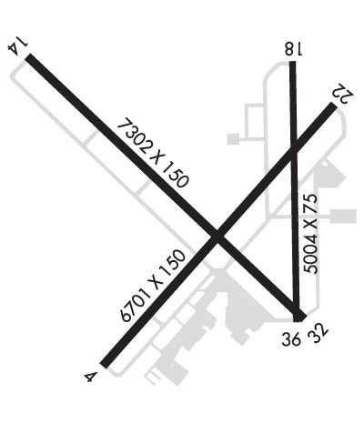
Runway Identifications
Runway Identification: 04/22Length: 6701 ft
Width: 150 ft
Surface: ASPHALT-FAIR CONDITION
Edge lights: High IntensityTreatment: GROOVED
Weight: PCN 17 /F/C/X/T
| | Runway: 04 | | Runway: 22 |
| Mag heading: | 44° | Mag heading: | 224° |
| Rwy Slope: | .02% Up | Rwy Slope: | -.02% Down |
| Approach: | ILS | Approach: | |
| Pattern: | Left Traffic | Pattern: | Left Traffic |
| Markings: | PRECISION INSTRUMENT | Markings: | PRECISION INSTRUMENT |
| Marking Condition: | GOOD | Marking Condition: | GOOD |
| Arresting Dev: | | Arresting Dev: | |
| Lat & Long: | N4236.7 W08903.0 | Lat. & Long.: | N4237.5 W08902.0 |
| Elev: | 803.7 ft. MSL | Elev: | 804.8 ft. MSL |
| TCH: | 54 ft. AGL | TCH: | 45 ft. AGL |
| Visual Glide Path: | 3.00 degrees | Visual Glide Path: | 3.00 degrees |
| Displaced Threshold: | No | Displaced Threshold: | No |
| Touchdown Zone: | YES | Touchdown Zone: | YES |
| Touchdown Elev.: | 805.7 feet | Touchdown Elev.: | 805.5 feet |
| Visual Glide Slope: | 4-Light PAPI on LEFT side of Runway | Visual Glide Slope: | 4-Light PAPI on LEFT side of Runway |
| RVR Equipment: | | RVR Equipment: | |
| RVV Equipment: | NO | RVV Equipment: | NO |
| Approach Lights: | MALSR - 1,400 foot medium intensity approach lighting system with runway alignment indicator lights | Approach Lights: | |
| REIL: | NO | REIL: | YES |
| Centerline Lights: | NO | Centerline Lights: | NO |
| Touchdown lights: | NO | Touchdown lights: | NO |
| Runway Category: | Precision Instrument Runway | Runway Category: | Runway with a Non-precision Approach having visibility minimums greater than 3/4 mile |
| Declared Distances: | TORA:6701' TODA:6701' ASDA:6701' LDA:6701' | Declared Distances: | TORA:6701' TODA:6701' ASDA:6701' LDA:6701' |
| Obstructions: | | Obstructions: | TREE |
| Marked: | | Marked: | NOT Marked/Lighted |
| Clearance slope: | 50:1 | Clearance slope: | 31:1 |
| Obstruction height: | | Obstruction height: | 83 feet AGL |
| Dist. from runway: | | Dist. from runway: | 2792 feet |
| Centerline offset: | | Centerline offset: | 367 feet right of centerline |
| Comments: | | Comments: | |
Runway Identification: 14/32Length: 7302 ft
Width: 150 ft
Surface: CONCRETE-FAIR CONDITION
Edge lights: High IntensityTreatment: GROOVED
Weight: PCN 17 /R/B/W/T
| | Runway: 14 | | Runway: 32 |
| Mag heading: | 136° | Mag heading: | 316° |
| Rwy Slope: | .14% Up | Rwy Slope: | -.14% Down |
| Approach: | | Approach: | ILS/DME |
| Pattern: | Left Traffic | Pattern: | Left Traffic |
| Markings: | PRECISION INSTRUMENT | Markings: | PRECISION INSTRUMENT |
| Marking Condition: | FAIR | Marking Condition: | GOOD |
| Arresting Dev: | | Arresting Dev: | |
| Lat & Long: | N4237.7 W08903.3 | Lat. & Long.: | N4236.9 W08902.1 |
| Elev: | 795.1 ft. MSL | Elev: | 805.4 ft. MSL |
| TCH: | 55 ft. AGL | TCH: | 51 ft. AGL |
| Visual Glide Path: | 3.00 degrees | Visual Glide Path: | 3.00 degrees |
| Displaced Threshold: | No | Displaced Threshold: | No |
| Touchdown Zone: | YES | Touchdown Zone: | YES |
| Touchdown Elev.: | 802.9 feet | Touchdown Elev.: | 806.2 feet |
| Visual Glide Slope: | 4-Light PAPI on LEFT side of Runway | Visual Glide Slope: | 4-BOX VASI ON LEFT SIDE OF RUNWAY |
| RVR Equipment: | | RVR Equipment: | |
| RVV Equipment: | NO | RVV Equipment: | NO |
| Approach Lights: | | Approach Lights: | MALSR - 1,400 foot medium intensity approach lighting system with runway alignment indicator lights |
| REIL: | YES | REIL: | NO |
| Centerline Lights: | NO | Centerline Lights: | NO |
| Touchdown lights: | NO | Touchdown lights: | NO |
| Runway Category: | D | Runway Category: | Precision Instrument Runway |
| Declared Distances: | TORA:7302' TODA:7302' ASDA:7302' LDA:7302' | Declared Distances: | TORA:7302' TODA:7302' ASDA:7302' LDA:7302' |
Runway Identification: 18/36Length: 5004 ft
Width: 75 ft
Surface: ASPHALT-FAIR CONDITION
Edge lights: Medium IntensityTreatment: NONE
Weight: PCN 6 /F/B/X/T
| | Runway: 18 | | Runway: 36 |
| Mag heading: | 181° | Mag heading: | 1° |
| Rwy Slope: | -.04% Down | Rwy Slope: | .04% Up |
| Approach: | | Approach: | |
| Pattern: | Left Traffic | Pattern: | Left Traffic |
| Markings: | BASIC | Markings: | BASIC |
| Marking Condition: | FAIR | Marking Condition: | FAIR |
| Arresting Dev: | | Arresting Dev: | |
| Lat & Long: | N4237.7 W08902.2 | Lat. & Long.: | N4236.8 W08902.2 |
| Elev: | 807.8 ft. MSL | Elev: | 805.7 ft. MSL |
| TCH: | | TCH: | |
| Visual Glide Path: | | Visual Glide Path: | |
| Displaced Threshold: | No | Displaced Threshold: | No |
| Touchdown Zone: | YES | Touchdown Zone: | YES |
| Touchdown Elev.: | 807.8 feet | Touchdown Elev.: | 806.4 feet |
| Visual Glide Slope: | | Visual Glide Slope: | |
| RVR Equipment: | | RVR Equipment: | |
| RVV Equipment: | NO | RVV Equipment: | NO |
| Approach Lights: | | Approach Lights: | |
| REIL: | NO | REIL: | NO |
| Centerline Lights: | NO | Centerline Lights: | NO |
| Touchdown lights: | NO | Touchdown lights: | NO |
| Runway Category: | Runway with a Visual Approach | Runway Category: | Runway with a Visual Approach |
| Declared Distances: | TORA:5004' TODA:5004' ASDA:5004' LDA:5004' | Declared Distances: | TORA:5004' TODA:5004' ASDA:5004' LDA:5004' |
| Obstructions: | ROAD | Obstructions: | |
| Marked: | NOT Marked/Lighted | Marked: | |
| Clearance slope: | 11:1 | Clearance slope: | 50:1 |
| Obstruction height: | 16 feet AGL | Obstruction height: | |
| Dist. from runway: | 385 feet | Dist. from runway: | |
| Centerline offset: | 20 right of centerline | Centerline offset: | |
| Comments: | | Comments: | |

