Current Weather/Notams (Metars, TAFs, Notams, NWS Forecast, PIREPS, and nearby weather)
Customs Information Send updates to Support@FltPlan.com
Customs Not Available
Database effective 04/18/2024
Airport Diagram might not be current.
|
| Facility Name: | SPRINGERVILLE MUNI |
| City Name: | SPRINGERVILLE |
| County: | APACHE |
| State abbrev: | AZ |
| State Name: | ARIZONA |
| | |
| Ownership: | PUBLICLY OWNED |
| Use: | OPEN TO THE PUBLIC |
| Owner's Name: | TOWN OF SPRINGERVILLE |
| Address: | 418 EAST MAIN STREET |
| | SPRINGERVILLE, AZ 85938 |
| Owner's Phone: | 928-333-2656 |
| | |
| Manager's Name: | SEAN KIENLE; AMGR: AIRPORT@SPRINGERVILLEAZ.GOV |
| Address: | 905 WEST AIRPORT RD |
| | SPRINGERVILLE, AZ 85938 |
| Phone: | 928-333-5746 |
| | |
| FAA Region: | WESTERN-PACIFIC |
| FAA Field Office: | PHX |
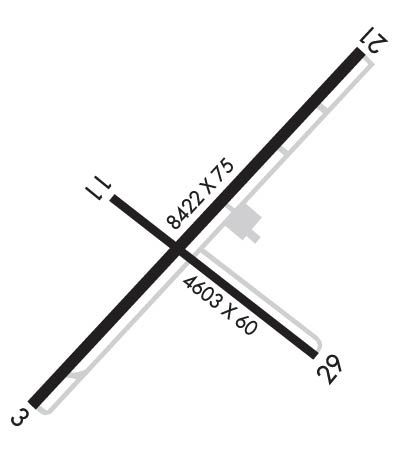
Runway Identifications
Runway Identification: 03/21Length: 8422 ft
Width: 75 ft
Surface: ASPHALT-GOOD CONDITION
Edge lights: Medium IntensityTreatment: NONE
| | Runway: 03 | | Runway: 21 |
| Mag heading: | 32° | Mag heading: | 212° |
| Rwy Slope: | -.52% Down | Rwy Slope: | .52% Up |
| Approach: | | Approach: | |
| Pattern: | Left Traffic | Pattern: | Right Traffic |
| Markings: | NONPRECISION INSTRUMENT | Markings: | NONPRECISION INSTRUMENT |
| Marking Condition: | GOOD | Marking Condition: | GOOD |
| Arresting Dev: | | Arresting Dev: | |
| Lat & Long: | N3407.3 W10919.2 | Lat. & Long.: | N3408.3 W10918.1 |
| Elev: | 7055.1 ft. MSL | Elev: | 7011.7 ft. MSL |
| TCH: | 46 ft. AGL | TCH: | 35 ft. AGL |
| Visual Glide Path: | 4.00 degrees | Visual Glide Path: | 3.00 degrees |
| Displaced Threshold: | No | Displaced Threshold: | No |
| Touchdown Zone: | YES | Touchdown Zone: | YES |
| Touchdown Elev.: | 7055.2 feet | Touchdown Elev.: | 7031.6 feet |
| Visual Glide Slope: | 2-Light PAPI on LEFT side of Runway | Visual Glide Slope: | 2-Light PAPI on LEFT side of Runway |
| RVR Equipment: | | RVR Equipment: | |
| RVV Equipment: | NO | RVV Equipment: | NO |
| Approach Lights: | | Approach Lights: | |
| REIL: | NO | REIL: | NO |
| Centerline Lights: | NO | Centerline Lights: | NO |
| Touchdown lights: | NO | Touchdown lights: | NO |
| Runway Category: | Runway with a Visual Approach | Runway Category: | Runway with a Non-precision Approach having visibility minimums greater than 3/4 mile |
| Declared Distances: | | Declared Distances: | |
Runway Identification: 11/29Length: 4603 ft
Width: 60 ft
Surface: ASPHALT-GOOD CONDITION
Edge lights: Medium IntensityTreatment: NONE
| | Runway: 11 | | Runway: 29 |
| Mag heading: | 116° | Mag heading: | 296° |
| Rwy Slope: | .20% Up | Rwy Slope: | -.20% Down |
| Approach: | | Approach: | |
| Pattern: | Left Traffic | Pattern: | Left Traffic |
| Markings: | BASIC | Markings: | BASIC |
| Marking Condition: | POOR | Marking Condition: | POOR |
| Arresting Dev: | | Arresting Dev: | |
| Lat & Long: | N3407.9 W10919.0 | Lat. & Long.: | N3407.4 W10918.3 |
| Elev: | 7032.8 ft. MSL | Elev: | 7042.0 ft. MSL |
| TCH: | 35 ft. AGL | TCH: | |
| Visual Glide Path: | 3.00 degrees | Visual Glide Path: | |
| Displaced Threshold: | No | Displaced Threshold: | No |
| Touchdown Zone: | YES | Touchdown Zone: | YES |
| Touchdown Elev.: | 7044.0 feet | Touchdown Elev.: | 7044.6 feet |
| Visual Glide Slope: | 2-Light PAPI on LEFT side of Runway | Visual Glide Slope: | |
| RVR Equipment: | | RVR Equipment: | |
| RVV Equipment: | NO | RVV Equipment: | NO |
| Approach Lights: | | Approach Lights: | |
| REIL: | NO | REIL: | NO |
| Centerline Lights: | NO | Centerline Lights: | NO |
| Touchdown lights: | NO | Touchdown lights: | NO |
| Runway Category: | Runway with a Visual Approach | Runway Category: | Runway with a Visual Approach |
| Declared Distances: | | Declared Distances: | |

