Click here for more info on on SMS!

KJKL

JULIAN CARROLL
JACKSON
KY
Time Zone: Eastern
Lat: N 3735.6
Long: W 08319.0
Elev: 1381
Var: +04
Longest Runway: 4400
AWOS: 118.37
CTAF: 122.8

FBO & Flight Services info for KJKL

FBOs: Update your Fuel Prices

J.CARROLL-NO FUELPh: 606-666-9907
-
Freq: 122.8
ASOSPh: 606-666-2794
-
Freq: 118.37  
If you are an FBO, call 1-203-262-1700 to update your info or email: FltPlan.Advertising@garmin.com
Advertise your FBO on FltPlan.com

Runway & Approach Info for KJKL
Rwy
Length
Land Dist**
Approach*
  Rwy
Length
Land Dist**
Approach*
01
4400x75  4400'          
 
  
19
  4400x75  4400'          
 
 * only ILS, LOC, LDA, and SDF approaches to a specific runway are shown
** For any Declared Landing Distance Available, please see A/FD or Approach plates
Runway Weight Capability (lbs.) Help
Runway IDSingle WheelDouble WheelDouble Tandem WheelDual Double Wheel
01/1912,500N/AN/AN/A
These numbers are Advisory and are not limits.   The Airport Manager should have more accurate Weight Limits
Approach Charts
Approaches    
Current Weather/Notams
Customs Information Send updates to Support@FltPlan.com
Customs Not Available
Database effective 04/18/2024
Airport Diagram of KJKL
Airport Diagram might not be current.

Facility Name: JULIAN CARROLL
City Name: JACKSON
County: BREATHITT
State abbrev: KY
State Name: KENTUCKY
   
Ownership: PUBLICLY OWNED
Use: OPEN TO THE PUBLIC
Owner's Name: JACKSON-BREATHITT COUNTY
Address: 208 AIRPORT ROAD
 JACKSON, KY 41339
Owner's Phone: (606) 666-3800
  
Manager's Name: JOHNNY DEATON; ARPT BOARD CHAIRMAN JOHNNY MACO DEATON
Address: 208 AIRPORT ROAD; AIRPORT ADDRESS 1333 AIRPORT ROAD, JACKSON KY 41339
 JACKSON, KY 41339
Phone: (606) 568-5356
   
FAA Region: SOUTHERN
FAA Field Office: MEM


Sunrise / Sunset times for JULIAN CARROLL

DateSunriseSunset
04/17/24 Wednesday6:5520:11
04/18/24 Thursday6:5320:12
04/19/24 Friday6:5220:13
04/20/24 Saturday6:5120:14
04/21/24 Sunday6:4920:15
04/22/24 Monday6:4820:16
04/23/24 Tuesday6:4720:17
04/24/24 Wednesday6:4520:18
04/25/24 Thursday6:4420:19
04/26/24 Friday6:4320:20
04/27/24 Saturday6:4220:20
04/28/24 Sunday6:4020:21
04/29/24 Monday6:3920:22
04/30/24 Tuesday6:3820:23

Airport Facilities

Airport Attendance ScheduleUNATTENDED
Airport Status OPERATIONAL (This Status can change at any time - please check NOTAMS)
Airport Lighting ScheduleACTVT MIRL RY 01/19 & REILS RYS 0/19 - CTAF.
Airport Storage AvailableTie Downs
Extra Services AvailableNONE
Wind IndicatorYES - (unlit)
Control TowerNO
CTAF Frequency122.800
Unicom Frequency122.800
Rotating Beacon ColorWG
Segmented CircleYES
Landing FeeNO

Airport Inspection Data

Airport InspectedSTATE - performed by STATE AERONAUTICAL PERSONNEL
Inspection Date07/12/2022

Airport Services

Type of Fuel AvailableNone
Airframe Repair ServiceNONE
Power Plant Repair ServiceNONE

Geographic Data

LatitudeN3735.6
LongitudeW08319.0 (ESTIMATED)
Arpt Elevation1380ft (SURVEYED)
Magnetic Variation04W
3 miles NEof JACKSON
Traffic Pattern Altitude
Sectional ChartCINCINNATI

Aircraft Data

Operations (Reported)YearlyAvg. Daily
General Aviation Transient 750
General Aviation Local 2001
Air Taxi 500
Commerical 00
Commuter 00
Military 500
Aircraft based on Field
General Aviation Singles 0
General Aviation Multi 0
Jet Aircraft 0
General Aviation Helicopters 0
Military Aircraft 0
Gliders 0
Ultralights 0

FAA Services

FSS on field NO
FSS tie-in LOUISVILLE
FSS Phone 1-800-WX-BRIEF
Who issues Notams JKL
Notam D service at airport YES
ARTCC Name INDIANAPOLIS

Federal Status

Airport Certification
Aircraft Rescue & Firefighting IndexNone
Airport of EntryNo
Custom Landing RightsNo
Joint Civil/MilitaryNo
Military Landing rightsNo

Federal Agreements

NATIONAL PLAN OF INTEGRATED AIRPORT SYSTEMS (NPIAS)

Remarks

FOR CD CTC INDIANAPOLIS ARTCC AT 317-247-2411.
Airport Communications & Frequencies:
CTAF Frequency:
122.800
Unicom Frequency:
122.800
Remarks
  • APCH/DEP SVC PRVDD BY INDIANAPOLIS ARTCC ON FREQS 126.575/257.85 (BLUEFIELD RCAG).
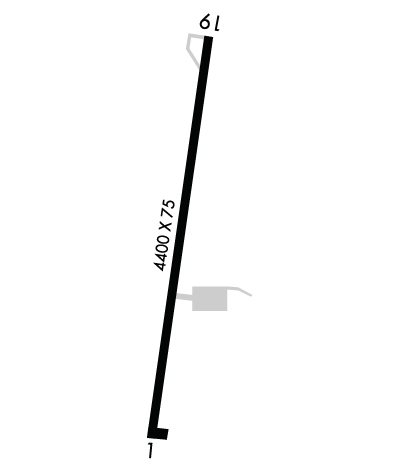
  • Runway Identifications
    Runway Identification: 01/19
    Length: 4400 ft
    Width: 75 ft
    Surface: ASPHALT-FAIR CONDITION
    Edge lights: Medium Intensity

    Treatment: NONE

     Runway: 01   Runway: 19
    Mag heading: 12°Mag heading: 192°
    Rwy Slope: .64% UpRwy Slope: -.64% Down
    Approach: Approach:
    Pattern: Left TrafficPattern: Left Traffic
    Markings: NONPRECISION INSTRUMENTMarkings: NONPRECISION INSTRUMENT
    Marking Condition: POOR; MARKINGS FADED AND ALGAE COVEREDMarking Condition: POOR; MARKINGS FADED AND ALGAE COVERED
    Arresting Dev: Arresting Dev:
    Lat & Long: N3735.3  W08319.1Lat. & Long.: N3736.0  W08319.0
    Elev: 1352.9 ft. MSLElev: 1380.9 ft. MSL
    TCH: TCH:
    Visual Glide Path: Visual Glide Path:
    Displaced Threshold: NoDisplaced Threshold: No
    Touchdown Zone: YESTouchdown Zone: YES
    Touchdown Elev.: 1367.1 feetTouchdown Elev.: 1380.9 feet
    Visual Glide Slope: Visual Glide Slope:
    RVR Equipment: RVR Equipment:
    RVV Equipment: NORVV Equipment: NO
    Approach Lights: Approach Lights:
    REIL: YESREIL: YES
    Centerline Lights: NOCenterline Lights: NO
    Touchdown lights: NOTouchdown lights: NO
    Runway Category: Runway with a Non-precision ApproachRunway Category: Runway with a Visual Approach
    Declared Distances: Declared Distances:
    Obstructions: TREESObstructions: TREES
    Marked: NOT Marked/LightedMarked: NOT Marked/Lighted
    Clearance slope: 1:1Clearance slope: 1:1
    Obstruction height: 22 feet AGLObstruction height: 14 feet AGL
    Dist. from runway: 206 feetDist. from runway: 202 feet
    Centerline offset: 102 left of centerlineCenterline offset: 95 feet right of centerline
    Comments: TREES AND BRUSH LOCATED WITHIN 200' OF THE THRESHOLD LEFT OF THE APPROACHComments: TREES AND BRUSH LOCATED WITHIN 200' OF THE THRESHOLD RIGHT OF THE APPROACH
    C:/P: