
| ||||||||||||||||||||||||||||||||||||||||||||
| ||||||||||||||||||||||||||||||||||||||||||||
| ||||||||||||||||||||||||||||||||||||||||||||
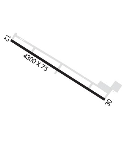
| Rwy | Rwy | |||||||
| 4300x75 | 4300' | 4300x75 | 4300' | |||||
| Runway ID | Single Wheel | Double Wheel | Double Tandem Wheel | Dual Double Wheel |
| 12/30 | N/A | N/A | N/A | N/A |
| These numbers are Advisory and are not limits. The Airport Manager should have more accurate Weight Limits | ||||
 Airport Diagram might not be current. | |
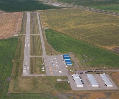
| Facility Name: | MOORHEAD MUNI/FLORENCE KLINGENSMITH FLD |
| City Name: | MOORHEAD |
| County: | CLAY |
| State abbrev: | MN |
| State Name: | MINNESOTA |
| Ownership: | PUBLICLY OWNED |
| Use: | OPEN TO THE PUBLIC |
| Owner's Name: | CITY OF MOORHEAD |
| Address: | 500 CENTER AVE BOX 779 |
| MOORHEAD, MN 56560-1922 | |
| Owner's Phone: | 218-299-5332 |
| Manager's Name: | MATT OVERHOLT |
| Address: | 3309 70TH ST S |
| MOORHEAD, MN 56547-9607 | |
| Phone: | 701-566-2113; CELL 701-866-1495. |
| FAA Region: | GREAT LAKES |
| FAA Field Office: | DMA |
| Date | Sunrise | Sunset |
|---|---|---|
| 04/19/24 Friday | 6:30 | 20:22 |
| 04/20/24 Saturday | 6:29 | 20:23 |
| 04/21/24 Sunday | 6:27 | 20:24 |
| 04/22/24 Monday | 6:25 | 20:26 |
| 04/23/24 Tuesday | 6:23 | 20:27 |
| 04/24/24 Wednesday | 6:22 | 20:28 |
| 04/25/24 Thursday | 6:20 | 20:30 |
| 04/26/24 Friday | 6:18 | 20:31 |
| 04/27/24 Saturday | 6:17 | 20:32 |
| 04/28/24 Sunday | 6:15 | 20:34 |
| 04/29/24 Monday | 6:13 | 20:35 |
| 04/30/24 Tuesday | 6:12 | 20:37 |
| 05/01/24 Wednesday | 6:10 | 20:38 |
| 05/02/24 Thursday | 6:09 | 20:39 |
| Airport Attendance Schedule | MON-FRI 0800-1700; FOR SVC AFT HRS CALL AMGR. |
| Airport Status | OPERATIONAL (This Status can change at any time - please check NOTAMS) |
| Airport Lighting Schedule | ACTVT REIL RWY 12 & 30; PAPI RWY 12 & 30; MIRL RWY 12/30 - CTAF. |
| Airport Storage Available | Tie Downs, Hanger |
| Extra Services Available | Aircraft Rental, Aircraft Sales |
| Wind Indicator | YES - (lighted) |
| Control Tower | NO |
| CTAF Frequency | 123.000 |
| Unicom Frequency | 123.000 |
| Rotating Beacon Color | WG |
| Segmented Circle | NO |
| Landing Fee |
| Airport Inspected | STATE - performed by STATE AERONAUTICAL PERSONNEL |
| Inspection Date | 09/09/2021 |
| Type of Fuel Available | Grade 100LL, JET A (freeze point -40C); -10FUEL AVBL H24 SELF SVC VIA CREDIT CARD. |
| Airframe Repair Service | MAJOR |
| Power Plant Repair Service | MAJOR |
| Latitude | N4650.4 |
| Longitude | W09639.8 (ESTIMATED) |
| Arpt Elevation | 918ft (SURVEYED) |
| Magnetic Variation | 03E |
| 4 miles SE | of MOORHEAD |
| Traffic Pattern Altitude | 800 |
| Sectional Chart | TWIN CITIES |
| Operations (Reported) | Yearly | Avg. Daily |
|---|---|---|
| General Aviation Transient | 3000 | 8 |
| General Aviation Local | 6000 | 16 |
| Air Taxi | 0 | 0 |
| Commerical | 0 | 0 |
| Commuter | 0 | 0 |
| Military | 0 | 0 |
| Aircraft based on Field | |
|---|---|
| General Aviation Singles | 41 |
| General Aviation Multi | 3 |
| Jet Aircraft | 0 |
| General Aviation Helicopters | 0 |
| Military Aircraft | 0 |
| Gliders | 0 |
| Ultralights | 0 |
| FSS on field | NO |
| FSS tie-in | PRINCETON |
| FSS Phone | 1-800-WX-BRIEF |
| Who issues Notams | JKJ |
| Notam D service at airport | YES |
| ARTCC Name | MINNEAPOLIS |
| Airport Certification | |
| Aircraft Rescue & Firefighting Index | None |
| Airport of Entry | No |
| Custom Landing Rights | No |
| Joint Civil/Military | No |
| Military Landing rights | No |
| NATIONAL PLAN OF INTEGRATED AIRPORT SYSTEMS (NPIAS) |
| ARPT UNDERLIES FARGO TRSA; HECTOR INTL CLASS D AIRSPACE 3 MILES NW OF ARPT. |
| NOISE ABATEMENT PROCS IN EFCT, CTC AMGR FOR DTLS. |
| GCO AVBL ON FREQ 121.725. |
| FOR CD CTC FARGO APCH AT 701-235-8894. |
Airport Communications & Frequencies:
| ||||||||||||||
| Runway: 12 | Runway: 30 | ||
| Mag heading: | 113° | Mag heading: | 293° |
| Rwy Slope: | .07% Up | Rwy Slope: | -.07% Down |
| Approach: | Approach: | ||
| Pattern: | Left Traffic | Pattern: | Left Traffic |
| Markings: | NONPRECISION INSTRUMENT | Markings: | NONPRECISION INSTRUMENT |
| Marking Condition: | GOOD | Marking Condition: | GOOD |
| Arresting Dev: | Arresting Dev: | ||
| Lat & Long: | N4650.5 W09640.3 | Lat. & Long.: | N4650.2 W09639.4 |
| Elev: | 914.5 ft. MSL | Elev: | 917.7 ft. MSL |
| TCH: | 25 ft. AGL | TCH: | 25 ft. AGL |
| Visual Glide Path: | 3.00 degrees | Visual Glide Path: | 3.00 degrees |
| Displaced Threshold: | No | Displaced Threshold: | No |
| Touchdown Zone: | YES | Touchdown Zone: | YES |
| Touchdown Elev.: | 915.4 feet | Touchdown Elev.: | 918.1 feet |
| Visual Glide Slope: | 4-Light PAPI on LEFT side of Runway | Visual Glide Slope: | 4-Light PAPI on LEFT side of Runway |
| RVR Equipment: | RVR Equipment: | ||
| RVV Equipment: | NO | RVV Equipment: | NO |
| Approach Lights: | Approach Lights: | ||
| REIL: | YES | REIL: | YES |
| Centerline Lights: | NO | Centerline Lights: | NO |
| Touchdown lights: | NO | Touchdown lights: | NO |
| Runway Category: | Runway with a Visual Approach | Runway Category: | Runway with a Non-precision Approach |
| Declared Distances: | Declared Distances: |