Click here for more info on on SMS!

KJHW

CHAUTAUQUA COUNTY/JAMESTOWN
JAMESTOWN
NY
Time Zone: Eastern
Lat: N 4209.2
Long: W 07915.5
Elev: 1723
Var: +10
Longest Runway: 5300
Clr Del: 126.05
AWOS: 118.42
CTAF: 122.97

FBO & Flight Services info for KJHW

FBOs: Update your Fuel Prices

CENTRIC AVIATIONPh: 716-201-1297
-
Freq: 123.50
Service
Jet
100LL
SAF
MoGas
Fuel Avail: Monday - Sunday 8:00am - 6:00pm / Tech on call 24/7 call anytime
Full6.957.75    Last Update: 04/23/2024 06:03
PRICES GUARANTEED by FBO.
Self        
 Address: 3163 AIRPORT DR BOX 5   JAMESTOWN, NY 14701
AWOSPh: 716-664-6005
-
Freq: 118.42  
If you are an FBO, call 1-203-262-1700 to update your info or email: FltPlan.Advertising@garmin.com
Advertise your FBO on FltPlan.com

Runway & Approach Info for KJHW
Rwy
Length
Land Dist**
Approach*
  Rwy
Length
Land Dist**
Approach*
07
5300x100  5300'          
 
  
25
  5300x100  5300'          
ILS/DME
 109.70 - 249°  
13
4499x100  4499'          
 
  
31
  4499x100  4499'          
 
 * only ILS, LOC, LDA, and SDF approaches to a specific runway are shown
** For any Declared Landing Distance Available, please see A/FD or Approach plates
Runway Weight Capability (lbs.) Help
Runway IDSingle WheelDouble WheelDouble Tandem WheelDual Double Wheel
07/2557,00095,000125,000N/A
13/3131,00056,000N/AN/A
These numbers are Advisory and are not limits.   The Airport Manager should have more accurate Weight Limits
Approach Charts
Approaches    
Current Weather/Notams
Customs Information Send updates to Support@FltPlan.com
Customs Not Available
Database effective 05/16/2024
Airport Diagram of KJHW
Airport Diagram might not be current.

Facility Name: CHAUTAUQUA COUNTY/JAMESTOWN
City Name: JAMESTOWN
County: CHAUTAUQUA
State abbrev: NY
State Name: NEW YORK
   
Ownership: PUBLICLY OWNED
Use: OPEN TO THE PUBLIC
Owner's Name: CHAUTAUQUA COUNTY
Address: NORTH ERIE ST., COUNTY OFFICE BLDGS
 MAYVILLE, NY 14757
Owner's Phone: 716-753-4000
  
Manager's Name: SHANNON BARNHART
Address: 3163 AIRPORT DR
 JAMESTOWN, NY 14701
Phone: 716-484-0204
   
FAA Region: EASTERN
FAA Field Office: NYC


Sunrise / Sunset times for CHAUTAUQUA COUNTY/JAMESTOWN

DateSunriseSunset
04/24/24 Wednesday6:2120:09
04/25/24 Thursday6:2020:10
04/26/24 Friday6:1920:12
04/27/24 Saturday6:1720:13
04/28/24 Sunday6:1620:14
04/29/24 Monday6:1420:15
04/30/24 Tuesday6:1320:16
05/01/24 Wednesday6:1220:17
05/02/24 Thursday6:1020:18
05/03/24 Friday6:0920:19
05/04/24 Saturday6:0820:20
05/05/24 Sunday6:0720:21
05/06/24 Monday6:0520:22
05/07/24 Tuesday6:0420:24

Airport Facilities

Airport Attendance ScheduleM-F 0600-1430 LCL
Airport Status OPERATIONAL (This Status can change at any time - please check NOTAMS)
Airport Lighting ScheduleACTVT MALSR RWY 25; REIL RWY 31; PAPI RWY 13 & 31; VASI RWY 07; HIRL RWY 07/25; MIRL RWY 13/31 & TWY LGTS - CTAF.
Airport Storage AvailableTie Downs, Hanger
Extra Services AvailableAir Freight, Flight Instruction, Aircraft Rental, Aircraft Sales
Wind IndicatorYES - (lighted)
Control TowerNO
CTAF Frequency122.975
Unicom Frequency122.975
Rotating Beacon ColorWG
Segmented CircleYES
Landing FeeYES; LNDG FEE MULTI-ENGINE ACFT ONLY.

Airport Inspection Data

Airport Inspected5010-1 PUBLIC USE MAILOUT PROGRAM - performed by FAA AIRPORTS FIELD PERSONNEL
Inspection Date09/26/2022

Airport Services

Type of Fuel AvailableGrade 100LL, JET A (freeze point -40C)
Airframe Repair ServiceMAJOR
Power Plant Repair ServiceMAJOR

Geographic Data

LatitudeN4209.2
LongitudeW07915.5 (ESTIMATED)
Arpt Elevation1723ft (SURVEYED)
Magnetic Variation10W
3 miles Nof JAMESTOWN
Traffic Pattern Altitude
Sectional ChartDETROIT

Aircraft Data

Operations (Reported)YearlyAvg. Daily
General Aviation Transient 25517
General Aviation Local 688119
Air Taxi 00
Commerical 00
Commuter 00
Military 130
Aircraft based on Field
General Aviation Singles 15
General Aviation Multi 5
Jet Aircraft 0
General Aviation Helicopters 1
Military Aircraft 0
Gliders 0
Ultralights 0

FAA Services

FSS on field NO
FSS tie-in BUFFALO
FSS Phone 1-800-WX-BRIEF
Who issues Notams JHW
Notam D service at airport YES
ARTCC Name CLEVELAND

Federal Status

Airport CertificationAIRPORT RECEIVING SCHEDULED AIR CARRIER SERVICE FROM CARRIERS CERTIFICATED BY THE CIVIL AERONAUTICS BOARD
Aircraft Rescue & Firefighting IndexAIRPORT HAS A CERTIFICATE UNDER CFR PART 139
Airport of EntryNo
Custom Landing RightsNo
Joint Civil/MilitaryNo
Military Landing rightsYES

Federal Agreements

NATIONAL PLAN OF INTEGRATED AIRPORT SYSTEMS (NPIAS)
GRANT AGREEMENTS UNDER FAAP/ADAP/AIP
COMPLIANCE WITH ACCESSIBILITY TO THE HANDICAPPED
SURPLUS PROPERTY AGREEMENT UNDER PUBLIC LAW 289
ASSURANCES PURSUANT TO TITLE VI, CIVIL RIGHTS ACT OF 1964

Remarks

DEER AND BIRDS ON & INVOF ARPT.
SNOW REMOVAL OPS AVBL DURING NORMAL ATTENDANCE HRS; SNOW REMOVAL MAY BE LIMITED ON HOLIDAYS & WEEKENDS.
FOR CD CTC BUFFALO APCH AT 716-626-6920, WHEN APCH CLSD CTC CLEVELAND ARTCC AT 440-774-0232.
ATTENDANCE HRS AND SERVICES AVAILABLE ARE SUBJECT TO CHANGE, CALL AIRPORT MANAGER AT 716-484-0204 TO CONFIRM.
RWY/TWY CONDITIONS NOT MONITORED OUTSIDE OF NORMAL ATTENDANCE HRS.
24 HR PPR FOR AIR CARRIER OPS WITH MORE THAN 9 PAX SEATS. CONTACT ARPT MGR AT 716-484-0204. FOR EMERGENCIES AFTER HRS, CALL 911 FOR MUTUAL AID SERVICE.
ARFF INDEX B CPBL.
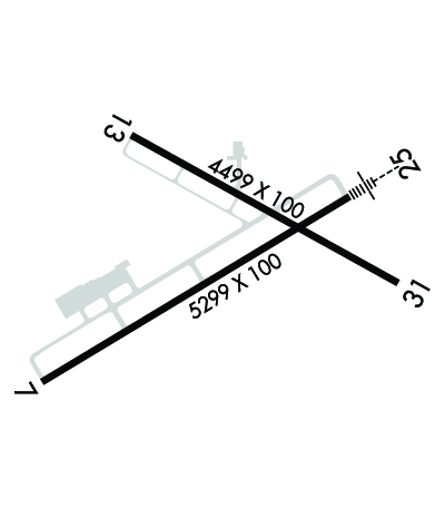
RWY 07/2 5 PCR VALUE: 250/F/B/W/T
RWY 13/3 1 PCR VALUE: 148/F/C/W/T
Airport Communications & Frequencies:
CTAF Frequency:
122.975
Unicom Frequency:
122.975
Remarks
  • APCH/DEP SVC PRVDD BY BUFFALO APCH (BUF) ON 126.05 0600-0000. APCH/DEP SVC PRVDD BY CLEVELAND ARTCC (ZOB) ON FREQ 127.075/292.175 (WATERFORD RCAG) 0000-0600.
  • BUFFALO Primary Approach Frequencies:  
    126.05
    BUFFALO Primary Departure Frequencies:  
    126.05
    Runway Identifications
    Runway Identification: 07/25
    Length: 5300 ft
    Width: 100 ft
    Surface: ASPHALT
    Edge lights: High Intensity

    Treatment: GROOVED

     Runway: 07   Runway: 25
    Mag heading: 69°Mag heading: 249°
    Rwy Slope: -.04% DownRwy Slope: .04% Up
    Approach: Approach: ILS/DME
    Pattern: Left TrafficPattern: Left Traffic
    Markings: NONPRECISION INSTRUMENTMarkings: PRECISION INSTRUMENT
    Marking Condition: GOODMarking Condition: GOOD
    Arresting Dev: Arresting Dev:
    Lat & Long: N4208.9  W07916.1Lat. & Long.: N4209.3  W07915.1
    Elev: 1720.6 ft. MSLElev: 1718.6 ft. MSL
    TCH: 52 ft. AGLTCH:
    Visual Glide Path: 3.00 degreesVisual Glide Path:
    Displaced Threshold: NoDisplaced Threshold: No
    Touchdown Zone: YESTouchdown Zone: YES
    Touchdown Elev.: 1721.6 feetTouchdown Elev.: 1721.2 feet
    Visual Glide Slope: 4-BOX VASI ON LEFT SIDE OF RUNWAYVisual Glide Slope:
    RVR Equipment: RVR Equipment:
    RVV Equipment: NORVV Equipment: NO
    Approach Lights: Approach Lights: MALSR - 1,400 foot medium intensity approach lighting system with runway alignment indicator lights
    REIL: NOREIL: NO
    Centerline Lights: NOCenterline Lights: NO
    Touchdown lights: NOTouchdown lights: NO
    Runway Category: Runway with a Non-precision Approach having visibility minimums greater than 3/4 mileRunway Category: Precision Instrument Runway
    Declared Distances: TORA:5300' TODA:5300' ASDA:5300' LDA:5300'Declared Distances: TORA:5300' TODA:5300' ASDA:5300' LDA:5300'
    Runway Identification: 13/31
    Length: 4499 ft
    Width: 100 ft
    Surface: ASPHALT-FAIR CONDITION
    Edge lights: Medium Intensity

    Treatment: NONE

     Runway: 13   Runway: 31
    Mag heading: 129°Mag heading: 309°
    Rwy Slope: -.36% DownRwy Slope: .36% Up
    Approach: Approach:
    Pattern: Left TrafficPattern: Left Traffic
    Markings: NONPRECISION INSTRUMENTMarkings: NONPRECISION INSTRUMENT
    Marking Condition: GOODMarking Condition: GOOD
    Arresting Dev: Arresting Dev:
    Lat & Long: N4209.5  W07915.8Lat. & Long.: N4209.1  W07914.9
    Elev: 1723.3 ft. MSLElev: 1707.2 ft. MSL
    TCH: 45 ft. AGLTCH: 51 ft. AGL
    Visual Glide Path: 3.00 degreesVisual Glide Path: 3.00 degrees
    Displaced Threshold: NoDisplaced Threshold: No
    Touchdown Zone: YESTouchdown Zone: YES
    Touchdown Elev.: 1723.3 feetTouchdown Elev.: 1715.2 feet
    Visual Glide Slope: 4-Light PAPI on LEFT side of RunwayVisual Glide Slope: 4-Light PAPI on LEFT side of Runway
    RVR Equipment: RVR Equipment:
    RVV Equipment: NORVV Equipment: NO
    Approach Lights: Approach Lights:
    REIL: NOREIL: YES
    Centerline Lights: NOCenterline Lights: NO
    Touchdown lights: NOTouchdown lights: NO
    Runway Category: Runway with a Non-precision Approach having visibility minimums greater than 3/4 mileRunway Category: Runway with a Non-precision Approach having visibility minimums greater than 3/4 mile
    Declared Distances: TORA:4499' TODA:4499' ASDA:4499' LDA:4499'Declared Distances: TORA:4499' TODA:4499' ASDA:4499' LDA:4499'
    Obstructions: TREEObstructions: BLDG
    Marked: NOT Marked/LightedMarked: MARKED and LIGHTED
    Clearance slope: 17:1Clearance slope: 16:1
    Obstruction height: 69 feet AGLObstruction height: 61 feet AGL
    Dist. from runway: 1400 feetDist. from runway: 1200 feet
    Centerline offset: 240 left of centerlineCenterline offset: 300 feet left of centerline
    Comments: Comments:
    C:9/P: