Current Weather/Notams (Metars, TAFs, Notams, NWS Forecast, PIREPS, and nearby weather)
Customs Information Send updates to Support@FltPlan.com
Customs Not Available
Database effective 04/18/2024
Airport Diagram might not be current.
|
| Facility Name: | STANTON COUNTY MUNI |
| City Name: | JOHNSON |
| County: | STANTON |
| State abbrev: | KS |
| State Name: | KANSAS |
| | |
| Ownership: | PUBLICLY OWNED |
| Use: | OPEN TO THE PUBLIC |
| Owner's Name: | STANTON COUNTY |
| Address: | 201 N MAIN ST |
| | JOHNSON, KS 67855 |
| Owner's Phone: | 620-492-2140 |
| | |
| Manager's Name: | JACOB NIX |
| Address: | 105 N. AIRPORT ROAD, 105 N. AIRPORT ROAD |
| | JOHNSON, KS 67855 |
| Phone: | 620-492-2414 |
| | |
| FAA Region: | CENTRAL |
| FAA Field Office: | NONE |
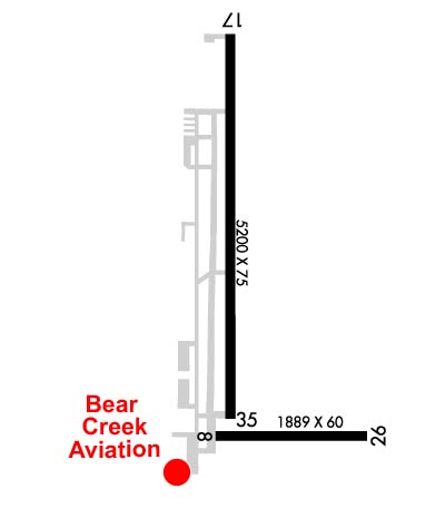
Runway Identifications
Runway Identification: 08/26Length: 1889 ft
Width: 60 ft
Surface: ASPHALT-GOOD CONDITION
Edge lights: Treatment: NONE
Weight: PCN 4 /R/C/Y/U
| | Runway: 08 | | Runway: 26 |
| Mag heading: | 83° | Mag heading: | 263° |
| Rwy Slope: | -.20% Down | Rwy Slope: | .20% Up |
| Approach: | | Approach: | |
| Pattern: | Left Traffic | Pattern: | Left Traffic |
| Markings: | | Markings: | |
| Marking Condition: | | Marking Condition: | |
| Arresting Dev: | | Arresting Dev: | |
| Lat & Long: | N3734.8 W10144.0 | Lat. & Long.: | N3734.8 W10143.6 |
| Elev: | 3324.2 ft. MSL | Elev: | 3320.5 ft. MSL |
| TCH: | | TCH: | |
| Visual Glide Path: | | Visual Glide Path: | |
| Displaced Threshold: | No | Displaced Threshold: | No |
| Touchdown Zone: | YES | Touchdown Zone: | YES |
| Touchdown Elev.: | 3324.4 feet | Touchdown Elev.: | 3324.4 feet |
| Visual Glide Slope: | | Visual Glide Slope: | |
| RVR Equipment: | | RVR Equipment: | |
| RVV Equipment: | NO | RVV Equipment: | NO |
| Approach Lights: | | Approach Lights: | |
| REIL: | NO | REIL: | NO |
| Centerline Lights: | NO | Centerline Lights: | NO |
| Touchdown lights: | NO | Touchdown lights: | NO |
| Runway Category: | Runway with a Visual Approach | Runway Category: | Runway with a Visual Approach |
| Declared Distances: | | Declared Distances: | |
| Obstructions: | PVT ROAD 11 FEET BLW AER 26. | Obstructions: | |
| Marked: | NOT Marked/Lighted | Marked: | |
| Clearance slope: | 50:1 | Clearance slope: | 50:1 |
| Obstruction height: | | Obstruction height: | |
| Dist. from runway: | | Dist. from runway: | |
| Centerline offset: | | Centerline offset: | |
| Comments: | +15 ROAD AT APCH END RY 08. | Comments: | |
Runway Identification: 17/35Length: 5200 ft
Width: 75 ft
Surface: CONCRETE
Edge lights: Medium IntensityTreatment: NONE
Weight: PCN 11 /R/C/X/U
| | Runway: 17 | | Runway: 35 |
| Mag heading: | 173° | Mag heading: | 353° |
| Rwy Slope: | .03% Up | Rwy Slope: | -.03% Down |
| Approach: | | Approach: | |
| Pattern: | Left Traffic | Pattern: | Left Traffic |
| Markings: | NONPRECISION INSTRUMENT | Markings: | NONPRECISION INSTRUMENT |
| Marking Condition: | GOOD | Marking Condition: | GOOD |
| Arresting Dev: | | Arresting Dev: | |
| Lat & Long: | N3735.7 W10144.0 | Lat. & Long.: | N3734.8 W10144.0 |
| Elev: | 3324.0 ft. MSL | Elev: | 3325.3 ft. MSL |
| TCH: | 40 ft. AGL | TCH: | 40 ft. AGL |
| Visual Glide Path: | 3.00 degrees | Visual Glide Path: | 3.00 degrees |
| Displaced Threshold: | No | Displaced Threshold: | No |
| Touchdown Zone: | YES | Touchdown Zone: | YES |
| Touchdown Elev.: | 3324.0 feet | Touchdown Elev.: | 3325.3 feet |
| Visual Glide Slope: | 4-Light PAPI on LEFT side of Runway | Visual Glide Slope: | 4-Light PAPI on LEFT side of Runway |
| RVR Equipment: | | RVR Equipment: | |
| RVV Equipment: | NO | RVV Equipment: | NO |
| Approach Lights: | | Approach Lights: | |
| REIL: | NO | REIL: | NO |
| Centerline Lights: | NO | Centerline Lights: | NO |
| Touchdown lights: | NO | Touchdown lights: | NO |
| Runway Category: | Runway with a Non-precision Approach having visibility minimums greater than 3/4 mile | Runway Category: | Runway with a Non-precision Approach having visibility minimums greater than 3/4 mile |
| Declared Distances: | | Declared Distances: | |