
| ||||||||||||||||||||||||||||||||||||||||||||
| ||||||||||||||||||||||||||||||||||||||||||||
| ||||||||||||||||||||||||||||||||||||||||||||
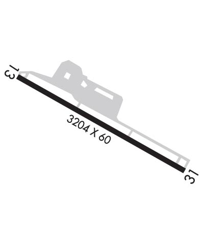
| Rwy | Rwy | |||||||
| 3204x60 | 3204' | 3204x60 | 3204' | |||||
| Runway ID | Single Wheel | Double Wheel | Double Tandem Wheel | Dual Double Wheel |
| 13/31 | 12,500 | N/A | N/A | N/A |
| H1 | N/A | N/A | N/A | N/A |
| These numbers are Advisory and are not limits. The Airport Manager should have more accurate Weight Limits | ||||
 Airport Diagram might not be current. | |
| Facility Name: | WILLIAMSBURG-JAMESTOWN |
| City Name: | WILLIAMSBURG |
| County: | JAMES CITY |
| State abbrev: | VA |
| State Name: | VIRGINIA |
| Ownership: | PRIVATELY OWNED |
| Use: | OPEN TO THE PUBLIC |
| Owner's Name: | WILLIAMSBURG-JAMESTOWN ARPT. |
| Address: | 100 MARCLAY RD |
| WILLIAMSBURG, VA 23185 | |
| Owner's Phone: | 757-229-9256 |
| Manager's Name: | LARRY T. WALTRIP |
| Address: | 100 MARCLAY RD |
| WILLIAMSBURG, VA 23185 | |
| Phone: | 757-229-9256 |
| FAA Region: | EASTERN |
| FAA Field Office: | DCA |
| Date | Sunrise | Sunset |
|---|---|---|
| 04/16/24 Tuesday | 6:30 | 19:44 |
| 04/17/24 Wednesday | 6:29 | 19:44 |
| 04/18/24 Thursday | 6:27 | 19:45 |
| 04/19/24 Friday | 6:26 | 19:46 |
| 04/20/24 Saturday | 6:25 | 19:47 |
| 04/21/24 Sunday | 6:23 | 19:48 |
| 04/22/24 Monday | 6:22 | 19:49 |
| 04/23/24 Tuesday | 6:21 | 19:50 |
| 04/24/24 Wednesday | 6:20 | 19:51 |
| 04/25/24 Thursday | 6:18 | 19:52 |
| 04/26/24 Friday | 6:17 | 19:53 |
| 04/27/24 Saturday | 6:16 | 19:53 |
| 04/28/24 Sunday | 6:15 | 19:54 |
| 04/29/24 Monday | 6:14 | 19:55 |
| Airport Attendance Schedule | NOV-FEB 7 Days A Week 0800-1800, MAR-OCT 7 Days A Week 0800-1900; ARPT UNATTND CHRISTMAS DAY - ATTND BY REQUEST. |
| Airport Status | OPERATIONAL (This Status can change at any time - please check NOTAMS) |
| Airport Lighting Schedule | ACTVT REIL RWY 13 & 31; MIRL RY 13/31; PERIMETER LGTS RY H1 - CTAF. |
| Airport Storage Available | Tie Downs, Hanger |
| Extra Services Available | Flight Instruction, Aircraft Rental |
| Wind Indicator | YES - (lighted) |
| Control Tower | NO |
| CTAF Frequency | 122.800 |
| Unicom Frequency | 122.800 |
| Rotating Beacon Color | WG |
| Segmented Circle | NO |
| Landing Fee | NO; LANDING FEE FOR COML & CHTR ACFT. |
| Airport Inspected | STATE - performed by STATE AERONAUTICAL PERSONNEL |
| Inspection Date | 04/20/2022 |
| Type of Fuel Available | Grade 100LL, JET A |
| Airframe Repair Service | MAJOR |
| Power Plant Repair Service | MAJOR |
| Latitude | N3714.4 |
| Longitude | W07643.0 (ESTIMATED) |
| Arpt Elevation | 49ft (SURVEYED) |
| Magnetic Variation | 11W |
| 3 miles SW | of WILLIAMSBURG |
| Traffic Pattern Altitude | 800 |
| Sectional Chart | WASHINGTON |
| Operations (Reported) | Yearly | Avg. Daily |
|---|---|---|
| General Aviation Transient | 11013 | 30 |
| General Aviation Local | 15314 | 42 |
| Air Taxi | 2754 | 8 |
| Commerical | 0 | 0 |
| Commuter | 0 | 0 |
| Military | 199 | 1 |
| Aircraft based on Field | |
|---|---|
| General Aviation Singles | 58 |
| General Aviation Multi | 1 |
| Jet Aircraft | 0 |
| General Aviation Helicopters | 0 |
| Military Aircraft | 0 |
| Gliders | 0 |
| Ultralights | 0 |
| FSS on field | NO |
| FSS tie-in | LEESBURG |
| FSS Phone | 1-800-WX-BRIEF |
| Who issues Notams | JGG |
| Notam D service at airport | YES |
| ARTCC Name | WASHINGTON |
| Airport Certification | |
| Aircraft Rescue & Firefighting Index | None |
| Airport of Entry | No |
| Custom Landing Rights | No |
| Joint Civil/Military | No |
| Military Landing rights | No |
| THIS AIRPORT HAS BEEN SURVEYED BY THE NATIONAL GEODETIC SURVEY. |
| DEER & BIRDS ON & INVOF ARPT. |
| NOISE ABATEMENT PROCEDURES IN EFFECT; CTC AMGR 757-229-9256. RY 31 DEP TURN LEFT HEADING 270 DEG TO AVOID SCHOOL 3500 FT OFF RY END. |
| GCO AVBL ON FREQ 135.075 THRU NORFOLK CD, 4 CLICKS NORFOLK, 5 LEESBURG RADIO (CLICK SLOWLY). IF UN, FOR CD CTC NORFOLK APCH AT 757-464-0757. |
| HELIPAD CLSD CT 122.8 FOR LDG INSTRUCTIONS. |
| PAEW ADJECENT TO RY 13/31. |
Airport Communications & Frequencies:
| ||||||||||||||
| Runway: 13 | Runway: 31 | ||
| Mag heading: | 131° | Mag heading: | 311° |
| Rwy Slope: | -.81% Down | Rwy Slope: | .81% Up |
| Approach: | Approach: | ||
| Pattern: | Right Traffic | Pattern: | Left Traffic |
| Markings: | BASIC | Markings: | BASIC |
| Marking Condition: | FAIR | Marking Condition: | FAIR |
| Arresting Dev: | Arresting Dev: | ||
| Lat & Long: | N3714.5 W07643.3 | Lat. & Long.: | N3714.2 W07642.7 |
| Elev: | 48.0 ft. MSL | Elev: | 22.0 ft. MSL |
| TCH: | TCH: | ||
| Visual Glide Path: | Visual Glide Path: | ||
| Displaced Threshold: | No | Displaced Threshold: | No |
| Touchdown Zone: | YES | Touchdown Zone: | YES |
| Touchdown Elev.: | 48.0 feet | Touchdown Elev.: | 48.0 feet |
| Visual Glide Slope: | Visual Glide Slope: | ||
| RVR Equipment: | RVR Equipment: | ||
| RVV Equipment: | NO | RVV Equipment: | NO |
| Approach Lights: | Approach Lights: | ||
| REIL: | YES | REIL: | YES |
| Centerline Lights: | NO | Centerline Lights: | NO |
| Touchdown lights: | NO | Touchdown lights: | NO |
| Runway Category: | Runway with a Visual Approach | Runway Category: | Runway with a Visual Approach |
| Declared Distances: | Declared Distances: | ||
| Obstructions: | TREES | Obstructions: | |
| Marked: | NOT Marked/Lighted | Marked: | |
| Clearance slope: | 17:1 | Clearance slope: | 20:1 |
| Obstruction height: | 106 feet AGL | Obstruction height: | |
| Dist. from runway: | 2016 feet | Dist. from runway: | |
| Centerline offset: | 269 right of centerline | Centerline offset: | |
| Comments: | Comments: | 20 FT TREE 156 FT FM THR 106 L OF CNTRLN; BRUSH APRX 127 FT FM THR, ARND PEN EDGE, 15 FT ABV RWY END. |
