Click here for more info on on SMS!

KJFZ

TAZEWELL COUNTY
RICHLANDS
VA
Time Zone: Eastern
Lat: N 3703.8
Long: W 08147.9
Elev: 2653
Var: +06
Longest Runway: 4299
Clr Del: 135.07 GCO
AWOS: 118.07
CTAF: 123.05

FBO & Flight Services info for KJFZ

FBOs: Update your Fuel Prices

TAZEWELL COUNTYPh: 276-963-4509 Fax: 276-963-3644 Freq: 123.05
Service
Jet
100LL
SAF
MoGas
Fuel Avail: PRIST PREMIXED
Full5.506.00    Last Update: 04/06/2024 14:12

Self        
 Address: 2200 AIRPORT RD,   CEDAR BLUFF, VA 24609
AWOSPh: 276-596-9927
-
Freq: 118.07  
If you are an FBO, call 1-203-262-1700 to update your info or email: FltPlan.Advertising@garmin.com
Advertise your FBO on FltPlan.com

Runway & Approach Info for KJFZ
Rwy
Length
Land Dist**
Approach*
  Rwy
Length
Land Dist**
Approach*
07
4299x75  4299'          
 
  
25
  4299x75  4299'          
LOC/DME
 109.75 - 251°  
 * only ILS, LOC, LDA, and SDF approaches to a specific runway are shown
** For any Declared Landing Distance Available, please see A/FD or Approach plates
Runway Weight Capability (lbs.) Help
Runway IDSingle WheelDouble WheelDouble Tandem WheelDual Double Wheel
07/2512,50018,000N/AN/A
These numbers are Advisory and are not limits.   The Airport Manager should have more accurate Weight Limits
Approach Charts
Approaches    
Current Weather/Notams
Customs Information Send updates to Support@FltPlan.com
Customs Not Available
Database effective 05/16/2024
Airport Diagram of KJFZ
Airport Diagram might not be current.

Facility Name: TAZEWELL COUNTY
City Name: RICHLANDS
County: TAZEWELL
State abbrev: VA
State Name: VIRGINIA
   
Ownership: PUBLICLY OWNED
Use: OPEN TO THE PUBLIC
Owner's Name: TAZEWELL CO AIRPORT AUTHORITY
Address: P.O. BOX 170
 CEDAR BLUFF, VA 24609
Owner's Phone: 276-963-4509
  
Manager's Name: JERRY MCREYNOLDS
Address: P.O. BOX 170
 CEDAR BLUFF, VA 24609
Phone: 276-963-4509
   
FAA Region: EASTERN
FAA Field Office: DCA


Sunrise / Sunset times for TAZEWELL COUNTY

DateSunriseSunset
04/25/24 Thursday6:3920:12
04/26/24 Friday6:3820:13
04/27/24 Saturday6:3720:13
04/28/24 Sunday6:3520:14
04/29/24 Monday6:3420:15
04/30/24 Tuesday6:3320:16
05/01/24 Wednesday6:3220:17
05/02/24 Thursday6:3120:18
05/03/24 Friday6:3020:19
05/04/24 Saturday6:2920:20
05/05/24 Sunday6:2820:21
05/06/24 Monday6:2720:21
05/07/24 Tuesday6:2620:22
05/08/24 Wednesday6:2520:23

Airport Facilities

Airport Attendance ScheduleMON-SAT 0800-1700; UNATTENDED - NEW YEARS DAY, THANKSGIVING, & CHRISTMAS.
Airport Status OPERATIONAL (This Status can change at any time - please check NOTAMS)
Airport Lighting ScheduleMIRL RWY 07/25 PRESET LOW INTST. TO INCREASE INTST & ACTVT REIL RWYS 07 & 25; PAPI RWY 07 & 25 - CTAF.
Airport Storage AvailableTie Downs
Extra Services AvailableAircraft Rental
Wind IndicatorYES - (lighted)
Control TowerNO
CTAF Frequency123.050
Unicom Frequency123.050
Rotating Beacon ColorWG
Segmented CircleYES
Landing Fee

Airport Inspection Data

Airport InspectedSTATE - performed by STATE AERONAUTICAL PERSONNEL
Inspection Date09/07/2023

Airport Services

Type of Fuel AvailableGrade 100LL, JET A
Airframe Repair ServiceNone
Power Plant Repair ServiceNone

Geographic Data

LatitudeN3703.8
LongitudeW08147.9 (ESTIMATED)
Arpt Elevation2653ft (SURVEYED)
Magnetic Variation06W
2 miles Sof RICHLANDS
Traffic Pattern Altitude
Sectional ChartCINCINNATI

Aircraft Data

Operations (Reported)YearlyAvg. Daily
General Aviation Transient 16134
General Aviation Local 386011
Air Taxi 00
Commerical 00
Commuter 00
Military 2881
Aircraft based on Field
General Aviation Singles 6
General Aviation Multi 4
Jet Aircraft 0
General Aviation Helicopters 0
Military Aircraft 0
Gliders 0
Ultralights 0

FAA Services

FSS on field NO
FSS tie-in LEESBURG
FSS Phone 1-800-WX-BRIEF
Who issues Notams JFZ
Notam D service at airport YES
ARTCC Name INDIANAPOLIS

Federal Status

Airport Certification
Aircraft Rescue & Firefighting IndexNone
Airport of EntryNo
Custom Landing RightsNo
Joint Civil/MilitaryNo
Military Landing rightsYES

Federal Agreements

NATIONAL PLAN OF INTEGRATED AIRPORT SYSTEMS (NPIAS)
GRANT AGREEMENTS UNDER FAAP/ADAP/AIP
ASSURANCES PURSUANT TO TITLE VI, CIVIL RIGHTS ACT OF 1964

Remarks

GCO AVBL ON FREQ 135.075 THRU ZTL CLEARANCE DELIVERY AND DCA RADIO - INOP.
FOR CD IF UNA VIA GCO CTC ATLANTA ARTCC AT 770-210-7692.
Airport Communications & Frequencies:
CTAF Frequency:
123.050
Unicom Frequency:
123.050
Remarks
  • APCH/DEP SVC PRVDD BY ATLANTA ARTCC (ZTL) ON FREQS 127.85/269.3 (GLADE SPRINGS RCAG).
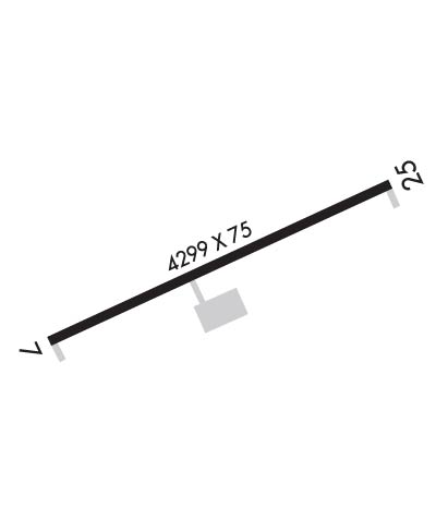
  • Runway Identifications
    Runway Identification: 07/25
    Length: 4299 ft
    Width: 75 ft
    Surface: ASPHALT-GOOD CONDITION
    Edge lights: Medium Intensity

    Treatment: NONE

     Runway: 07   Runway: 25
    Mag heading: 72°Mag heading: 252°
    Rwy Slope: .01% UpRwy Slope: -.01% Down
    Approach: Approach: LOC/DME
    Pattern: Left TrafficPattern: Left Traffic
    Markings: NONPRECISION INSTRUMENTMarkings: NONPRECISION INSTRUMENT
    Marking Condition: POOR; MARKINGS COVERED BY ALGAE.Marking Condition: POOR; MARKINGS COVERED BY ALGAE.
    Arresting Dev: Arresting Dev:
    Lat & Long: N3703.7  W08148.3Lat. & Long.: N3704.0  W08147.5
    Elev: 2652.8 ft. MSLElev: 2653.1 ft. MSL
    TCH: 47 ft. AGLTCH: 47 ft. AGL
    Visual Glide Path: 3.50 degreesVisual Glide Path: 3.50 degrees
    Displaced Threshold: NoDisplaced Threshold: No
    Touchdown Zone: YESTouchdown Zone: YES
    Touchdown Elev.: 2653.0 feetTouchdown Elev.: 2653.1 feet
    Visual Glide Slope: 2-Light PAPI on LEFT side of RunwayVisual Glide Slope: 2-Light PAPI on LEFT side of Runway
    RVR Equipment: RVR Equipment:
    RVV Equipment: NORVV Equipment: NO
    Approach Lights: Approach Lights:
    REIL: YESREIL: YES
    Centerline Lights: NOCenterline Lights: NO
    Touchdown lights: NOTouchdown lights: NO
    Runway Category: Runway with a Non-precision ApproachRunway Category: Runway with a Non-precision Approach
    Declared Distances: Declared Distances:
    Obstructions: TREESObstructions: TREE
    Marked: NOT Marked/LightedMarked: NOT Marked/Lighted
    Clearance slope: CTLNG OBSTN EXCEEDS A 45 DEG SLP.Clearance slope: 1:1
    Obstruction height: 8 feet AGLObstruction height: 17 feet AGL
    Dist. from runway: 204 feetDist. from runway: 227 feet
    Centerline offset: 132 left of centerlineCenterline offset: 131 feet left of centerline
    Comments: BRUSH 113 FT L OF CNTRLN AND OVER EMBANKMENT ADJ TO RWY.Comments:
    C:1/P: