Click here for more info on on SMS!

KJFX

WALKER COUNTY-BEVILL FIELD
JASPER
AL
Time Zone: Central
Lat: N 3354.1
Long: W 08718.8
Elev: 483
Var: +01
Longest Runway: 5004
AWOS: 119.22
CTAF: 122.7

FBO & Flight Services info for KJFX

FBOs: Update your Fuel Prices

SANDERS AVIATIONPh: 205-384-4359 Fax: 205-384-3843 Freq: 122.70
Service
Jet
100LL
SAF
MoGas
Fuel Avail: PRIST PREMIXED.
Full6.00      Last Update: 04/19/2024 12:43

Self service lounge open 24/7
Self6.005.99    
 Address: 20 ELLIS HAYNES DR., WALKER CO AIRPORT,   JASPER, AL 35504
AWOSPh: 205-295-5539
-
Freq: 119.22  
If you are an FBO, call 1-203-262-1700 to update your info or email: FltPlan.Advertising@garmin.com
Advertise your FBO on FltPlan.com

Runway & Approach Info for KJFX
Rwy
Length
Land Dist**
Approach*
  Rwy
Length
Land Dist**
Approach*
09
5004x100  5004'          
 
  
27
  5004x100  4814'          
ILS/DME
 108.90 - 272°  
 * only ILS, LOC, LDA, and SDF approaches to a specific runway are shown
** For any Declared Landing Distance Available, please see A/FD or Approach plates
Runway Weight Capability (lbs.) Help
Runway IDSingle WheelDouble WheelDouble Tandem WheelDual Double Wheel
09/2750,000N/AN/AN/A
These numbers are Advisory and are not limits.   The Airport Manager should have more accurate Weight Limits
Approach Charts
Approaches    
Current Weather/Notams
Customs Information Send updates to Support@FltPlan.com
Customs Not Available
Database effective 05/16/2024
Airport Diagram of KJFX
Airport Diagram might not be current.

Facility Name: WALKER COUNTY-BEVILL FLD
City Name: JASPER
County: WALKER
State abbrev: AL
State Name: ALABAMA
   
Ownership: PUBLICLY OWNED
Use: OPEN TO THE PUBLIC
Owner's Name: WALKER COUNTY COMMISSION; STEVE MILLER, CHAIRMAN. MIKE SHORT, CO ENGR, KEITH DUNCAN, ARPT MGR.
Address: 1801 3RD AVE. S., SUITE 113
 JASPER, AL 35501
Owner's Phone: 205-384-7230
  
Manager's Name: KEITH DUNCAN
Address: 198 BIDDLE DRIVE
 JASPER, AL 35503
Phone: 205-388-1294
   
FAA Region: SOUTHERN
FAA Field Office: JAN


Sunrise / Sunset times for WALKER COUNTY-BEVILL FLD

DateSunriseSunset
04/25/24 Thursday6:0619:29
04/26/24 Friday6:0519:30
04/27/24 Saturday6:0419:30
04/28/24 Sunday6:0319:31
04/29/24 Monday6:0219:32
04/30/24 Tuesday6:0119:33
05/01/24 Wednesday5:5919:33
05/02/24 Thursday5:5819:34
05/03/24 Friday5:5819:35
05/04/24 Saturday5:5719:36
05/05/24 Sunday5:5619:37
05/06/24 Monday5:5519:37
05/07/24 Tuesday5:5419:38
05/08/24 Wednesday5:5319:39

Airport Facilities

Airport Attendance ScheduleMON - SAT 0700-2000
Airport Status OPERATIONAL (This Status can change at any time - please check NOTAMS)
Airport Lighting ScheduleACTVT REIL RWY 9 & 27; VASI RWY 9 & 27; MIRL RWY 9/27- CTAF.
Airport Storage AvailableTie Downs
Extra Services AvailableFlight Instruction, Aircraft Rental
Wind IndicatorYES - (lighted)
Control TowerNO
CTAF Frequency122.700
Unicom Frequency122.700
Rotating Beacon ColorWG
Segmented CircleYES
Landing FeeNO

Airport Inspection Data

Airport InspectedSTATE - performed by STATE AERONAUTICAL PERSONNEL
Inspection Date03/17/2023

Airport Services

Type of Fuel AvailableGrade 100LL, JET A (freeze point -40C), JET A-1 (freeze point -50C); -10FUEL AVBL 24/7 WITH CC.
Airframe Repair ServiceMAJOR; NO OUTSIDE WORK EXCP EMERGS.
Power Plant Repair ServiceMAJOR; NO OUTSIDE WORK EXCP EMERGS.

Geographic Data

LatitudeN3354.1
LongitudeW08718.8 (ESTIMATED)
Arpt Elevation482ft (SURVEYED)
Magnetic Variation01W
5 miles NWof JASPER
Traffic Pattern Altitude
Sectional ChartATLANTA

Aircraft Data

Operations (Reported)YearlyAvg. Daily
General Aviation Transient 2870379
General Aviation Local 481313
Air Taxi 00
Commerical 00
Commuter 00
Military 1000
Aircraft based on Field
General Aviation Singles 14
General Aviation Multi 0
Jet Aircraft 0
General Aviation Helicopters 1
Military Aircraft 0
Gliders 0
Ultralights 0

FAA Services

FSS on field NO
FSS tie-in ANNISTON
FSS Phone 1-800-WX-BRIEF
Who issues Notams ANB
Notam D service at airport YES
ARTCC Name ATLANTA

Federal Status

Airport Certification
Aircraft Rescue & Firefighting IndexNone
Airport of EntryNo
Custom Landing RightsNo
Joint Civil/MilitaryNo
Military Landing rightsYES

Federal Agreements

NATIONAL PLAN OF INTEGRATED AIRPORT SYSTEMS (NPIAS)
GRANT AGREEMENTS UNDER FAAP/ADAP/AIP
ASSURANCES PURSUANT TO TITLE VI, CIVIL RIGHTS ACT OF 1964

Remarks

THIS AIRPORT HAS BEEN SURVEYED BY THE NATIONAL GEODETIC SURVEY.
DEER ON & INVOF RWYS.
GCO AVBL ON FREQ 121.725 THRU BIRMINGHAM (BHM) CLEARANCE DELIVERY.
FOR CD IF UNA VIA GCO CTC BIRMINGHAM APCH AT 205-769-3890.
Airport Communications & Frequencies:
CTAF Frequency:
122.700
Unicom Frequency:
122.700
BIRMINGHAM Primary Approach Frequencies:  
127.675
338.2
BIRMINGHAM Primary Departure Frequencies:  
127.675
338.2
Runway Identifications
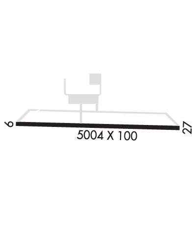
Runway Identification: 09/27
Length: 5004 ft
Width: 100 ft
Surface: ASPHALT-FAIR CONDITION
Edge lights: Medium Intensity

Treatment: NONE

 Runway: 09   Runway: 27
Mag heading: 93°Mag heading: 273°
Rwy Slope: -.17% DownRwy Slope: .17% Up
Approach: Approach: ILS/DME
Pattern: Left TrafficPattern: Left Traffic
Markings: NONPRECISION INSTRUMENTMarkings: PRECISION INSTRUMENT
Marking Condition: FAIRMarking Condition: FAIR
Arresting Dev: Arresting Dev:
Lat & Long: N3354.1  W08719.3Lat. & Long.: N3354.1  W08718.3
Elev: 482.3 ft. MSLElev: 473.8 ft. MSL
TCH: 39 ft. AGLTCH: 45 ft. AGL
Visual Glide Path: 3.00 degreesVisual Glide Path: 3.00 degrees
Displaced Threshold: NoDisplaced Threshold: 190 feet
Touchdown Zone: YESTouchdown Zone: YES
Touchdown Elev.: 482.6 feetTouchdown Elev.: 480.6 feet
Visual Glide Slope: 4-BOX VASI ON LEFT SIDE OF RUNWAYVisual Glide Slope: 4-BOX VASI ON LEFT SIDE OF RUNWAY
RVR Equipment: RVR Equipment:
RVV Equipment: NORVV Equipment: NO
Approach Lights: Approach Lights:
REIL: YESREIL: YES
Centerline Lights: NOCenterline Lights: NO
Touchdown lights: NOTouchdown lights: NO
Runway Category: Runway with a Non-precision Approach having visibility minimums greater than 3/4 mileRunway Category: Precision Instrument Runway
Declared Distances: TORA:5001' TODA:5001' ASDA:4800' LDA:4800'Declared Distances: TORA:5001' TODA:5001' ASDA:5001' LDA:4800'
Obstructions: TREESObstructions: TREES
Marked: NOT Marked/LightedMarked: NOT Marked/Lighted
Clearance slope: 15:1Clearance slope: 39:1
Obstruction height: 24 feet AGLObstruction height: 13 feet AGL
Dist. from runway: 570 feetDist. from runway: 716 feet
Centerline offset: 113 left of centerlineCenterline offset: 127 feet right of centerline
Comments: Comments:
C:8/P: