| |||||||||||||||||||||||||||||||||||||||||||||||||||||||||||||||||||||
| |||||||||||||||||||||||||||||||||||||||||||||||||||||||||||||||||||||
| |||||||||||||||||||||||||||||||||||||||||||||||||||||||||||||||||||||
| |||||||||||||||||||||||||||||||||||||||||||||||||||||||||||||||||||||
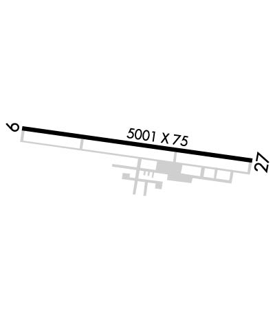
| Rwy | Rwy | |||||||
| 5002x75 | 5002' | 5002x75 | 5002' | |||||
| Runway ID | Single Wheel | Double Wheel | Double Tandem Wheel | Dual Double Wheel |
| 09/27 | 20,000 | N/A | N/A | N/A |
| These numbers are Advisory and are not limits. The Airport Manager should have more accurate Weight Limits | ||||
 Airport Diagram might not be current. | |
| Facility Name: | JEROME COUNTY |
| City Name: | JEROME |
| County: | JEROME |
| State abbrev: | ID |
| State Name: | IDAHO |
| Ownership: | PUBLICLY OWNED |
| Use: | OPEN TO THE PUBLIC |
| Owner's Name: | JEROME COUNTY |
| Address: | 300 N LINCOLN RM 300 |
| JEROME, ID 83338 | |
| Owner's Phone: | 208-644-2704 |
| Manager's Name: | MARTIN LUHR |
| Address: | 472A HWY 25 |
| JEROME, ID 83338 | |
| Phone: | 208-420-1158; ARPT MGR CELL (208) 308-3140 |
| FAA Region: | NORTHWEST MOUNTAIN |
| FAA Field Office: | HLN |
| Date | Sunrise | Sunset |
|---|---|---|
| 04/18/24 Thursday | 6:50 | 20:24 |
| 04/19/24 Friday | 6:49 | 20:26 |
| 04/20/24 Saturday | 6:47 | 20:27 |
| 04/21/24 Sunday | 6:46 | 20:28 |
| 04/22/24 Monday | 6:44 | 20:29 |
| 04/23/24 Tuesday | 6:43 | 20:30 |
| 04/24/24 Wednesday | 6:41 | 20:31 |
| 04/25/24 Thursday | 6:40 | 20:32 |
| 04/26/24 Friday | 6:38 | 20:34 |
| 04/27/24 Saturday | 6:37 | 20:35 |
| 04/28/24 Sunday | 6:35 | 20:36 |
| 04/29/24 Monday | 6:34 | 20:37 |
| 04/30/24 Tuesday | 6:32 | 20:38 |
| 05/01/24 Wednesday | 6:31 | 20:39 |
| Airport Attendance Schedule | 7 Days A Week 0800-1700 |
| Airport Status | OPERATIONAL (This Status can change at any time - please check NOTAMS) |
| Airport Lighting Schedule | ACTVT MIRL RWY 09/27 - CTAF. |
| Airport Storage Available | Tie Downs, Hanger, Buoys |
| Extra Services Available | Crop Dusting, Flight Instruction, Parachute Jumping |
| Wind Indicator | YES - (lighted) |
| Control Tower | NO |
| CTAF Frequency | 122.800 |
| Unicom Frequency | 122.800 |
| Rotating Beacon Color | WG |
| Segmented Circle | YES |
| Landing Fee | NO |
| Airport Inspected | STATE - performed by STATE AERONAUTICAL PERSONNEL |
| Inspection Date | 03/03/2022 |
| Type of Fuel Available | Grade 100LL, JET A (freeze point -40C), JET A |
| Airframe Repair Service | MAJOR |
| Power Plant Repair Service | MAJOR |
| Latitude | N4243.6 |
| Longitude | W11427.4 (ESTIMATED) |
| Arpt Elevation | 4053ft (SURVEYED) |
| Magnetic Variation | 14E |
| 3 miles E | of JEROME |
| Traffic Pattern Altitude | |
| Sectional Chart | SALT LAKE CITY |
| Operations (Reported) | Yearly | Avg. Daily |
|---|---|---|
| General Aviation Transient | 21500 | 59 |
| General Aviation Local | 4000 | 11 |
| Air Taxi | 0 | 0 |
| Commerical | 0 | 0 |
| Commuter | 0 | 0 |
| Military | 10 | 0 |
| Aircraft based on Field | |
|---|---|
| General Aviation Singles | 31 |
| General Aviation Multi | 1 |
| Jet Aircraft | 2 |
| General Aviation Helicopters | 5 |
| Military Aircraft | 0 |
| Gliders | 0 |
| Ultralights | 0 |
| FSS on field | NO |
| FSS tie-in | BOISE |
| FSS Phone | 1-800-WX-BRIEF |
| Who issues Notams | JER |
| Notam D service at airport | YES |
| ARTCC Name | SALT LAKE CITY |
| Airport Certification | |
| Aircraft Rescue & Firefighting Index | None |
| Airport of Entry | No |
| Custom Landing Rights | No |
| Joint Civil/Military | No |
| Military Landing rights | YES |
| NATIONAL PLAN OF INTEGRATED AIRPORT SYSTEMS (NPIAS) |
| GRANT AGREEMENTS UNDER FAAP/ADAP/AIP |
| ASSURANCES PURSUANT TO TITLE VI, CIVIL RIGHTS ACT OF 1964 |
| REFLECTORS ON PARALLEL TWY. |
| 18 CELL TWRS FARM LCTD 1.5 NM ENE OF ARPT AT 2500 FT RIGHT OF RWY 27 APPCH; TALLEST TWR IS 700 FT AGL. |
| FOR CD CTC TWIN FALLS APCH AT 208-734-7160, WHEN APCH CLSD CTC SALT LAKE ARTCC AT 801-320-2568. |
Airport Communications & Frequencies:
| |||||||||||||||||
| Runway: 09 | Runway: 27 | ||
| Mag heading: | 86° | Mag heading: | 266° |
| Rwy Slope: | 1.83% Up | Rwy Slope: | -1.83% Down |
| Approach: | Approach: | ||
| Pattern: | Right Traffic | Pattern: | Left Traffic |
| Markings: | NONPRECISION INSTRUMENT | Markings: | NONPRECISION INSTRUMENT |
| Marking Condition: | GOOD | Marking Condition: | GOOD |
| Arresting Dev: | Arresting Dev: | ||
| Lat & Long: | N4243.7 W11427.9 | Lat. & Long.: | N4243.5 W11426.8 |
| Elev: | 3961.5 ft. MSL | Elev: | 4053.1 ft. MSL |
| TCH: | 40 ft. AGL | TCH: | |
| Visual Glide Path: | 3.00 degrees | Visual Glide Path: | |
| Displaced Threshold: | No | Displaced Threshold: | No |
| Touchdown Zone: | YES | Touchdown Zone: | YES |
| Touchdown Elev.: | 4020.0 feet | Touchdown Elev.: | 4053.1 feet |
| Visual Glide Slope: | 4-Light PAPI on LEFT side of Runway | Visual Glide Slope: | |
| RVR Equipment: | RVR Equipment: | ||
| RVV Equipment: | NO | RVV Equipment: | NO |
| Approach Lights: | Approach Lights: | ||
| REIL: | NO | REIL: | NO |
| Centerline Lights: | NO | Centerline Lights: | NO |
| Touchdown lights: | NO | Touchdown lights: | NO |
| Runway Category: | Runway with a Non-precision Approach having visibility minimums greater than 3/4 mile | Runway Category: | Runway with a Non-precision Approach having visibility minimums greater than 3/4 mile |
| Declared Distances: | Declared Distances: | ||
| Obstructions: | Unknown | Obstructions: | FENCE |
| Marked: | NOT Marked/Lighted | Marked: | NOT Marked/Lighted |
| Clearance slope: | 50:1 | Clearance slope: | 25:1 |
| Obstruction height: | 0 feet AGL | Obstruction height: | 8 feet AGL |
| Dist. from runway: | 0 feet | Dist. from runway: | 400 feet |
| Centerline offset: | Centerline offset: | 150 feet left of centerline | |
| Comments: | Comments: |