Current Weather/Notams (Metars, TAFs, Notams, NWS Forecast, PIREPS, and nearby weather)
Customs Information Send updates to Support@FltPlan.com
Customs Not Available
Database effective 05/16/2024
Airport Diagram might not be current.
|
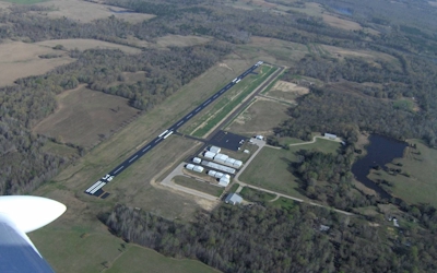
| Facility Name: | WOOD COUNTY/COLLINS FLD |
| City Name: | MINEOLA/QUITMAN |
| County: | WOOD |
| State abbrev: | TX |
| State Name: | TEXAS |
| | |
| Ownership: | PUBLICLY OWNED |
| Use: | OPEN TO THE PUBLIC |
| Owner's Name: | WOOD COUNTY |
| Address: | WOOD COUNTY COURTHOUSE |
| | QUITMAN, TX 75783 |
| Owner's Phone: | 903-768-2100 |
| | |
| Manager's Name: | JOHN WISDOM |
| Address: | 317 COUNTY RD 2355 |
| | MINEOLA, TX 75773-3715 |
| Phone: | 903-768-2100 |
| | |
| FAA Region: | SOUTHWEST |
| FAA Field Office: | TEX |
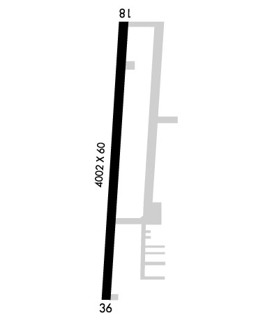
Runway Identifications
Runway Identification: 18/36Length: 4002 ft
Width: 60 ft
Surface: ASPHALT-FAIR CONDITION
Edge lights: Medium IntensityTreatment: NONE
| | Runway: 18 | | Runway: 36 |
| Mag heading: | 180° | Mag heading: | 0° |
| Rwy Slope: | .75% Up | Rwy Slope: | -.75% Down |
| Approach: | | Approach: | |
| Pattern: | Left Traffic | Pattern: | Left Traffic |
| Markings: | NONPRECISION INSTRUMENT | Markings: | NONPRECISION INSTRUMENT |
| Marking Condition: | FAIR | Marking Condition: | FAIR |
| Arresting Dev: | | Arresting Dev: | |
| Lat & Long: | N3244.9 W09529.8 | Lat. & Long.: | N3244.2 W09529.8 |
| Elev: | 402.5 ft. MSL | Elev: | 432.6 ft. MSL |
| TCH: | 30 ft. AGL | TCH: | 42 ft. AGL |
| Visual Glide Path: | 3.00 degrees | Visual Glide Path: | 3.00 degrees |
| Displaced Threshold: | No | Displaced Threshold: | No |
| Touchdown Zone: | YES | Touchdown Zone: | YES |
| Touchdown Elev.: | 421.1 feet | Touchdown Elev.: | 432.9 feet |
| Visual Glide Slope: | 2-Light PAPI on LEFT side of Runway | Visual Glide Slope: | 2-Light PAPI on LEFT side of Runway; PAPI UNUSBL 6 DEGS LEFT OF CNTRLN. |
| RVR Equipment: | | RVR Equipment: | |
| RVV Equipment: | NO | RVV Equipment: | NO |
| Approach Lights: | | Approach Lights: | |
| REIL: | NO | REIL: | NO |
| Centerline Lights: | NO | Centerline Lights: | NO |
| Touchdown lights: | NO | Touchdown lights: | NO |
| Runway Category: | Runway with a Non-precision Approach | Runway Category: | Runway with a Non-precision Approach |
| Declared Distances: | | Declared Distances: | |
| Obstructions: | TREES | Obstructions: | TREES |
| Marked: | NOT Marked/Lighted | Marked: | NOT Marked/Lighted |
| Clearance slope: | 20:1 | Clearance slope: | |
| Obstruction height: | 90 feet AGL | Obstruction height: | 70 feet AGL |
| Dist. from runway: | 2000 feet | Dist. from runway: | 201 feet |
| Centerline offset: | | Centerline offset: | 234 feet right of centerline |
| Comments: | | Comments: | 70 FT TREES 45-200 FT DSTC, 234 FT R. |