Click here for more info on on SMS!

KJCA

JACKSON COUNTY
JEFFERSON
GA
Time Zone: Eastern
Lat: N 3410.6
Long: W 08333.7
Elev: 951
Var: +05
Longest Runway: 5010
AWOS: 118.12
CTAF: 122.97

FBO & Flight Services info for KJCA

FBOs: Update your Fuel Prices

JACKSON CTY APPh: 706-367-1493
-
Freq: 122.8
Service
Jet
100LL
SAF
MoGas
Fuel Avail: SS 24/7, FS JET A with prior arrangement PRIST+$0.10/gal
Full4.49      Last Update: 03/29/2024 09:39

Self4.195.79    
AWOSPh: 706-367-1607
-
Freq: 118.12  
If you are an FBO, call 1-203-262-1700 to update your info or email: FltPlan.Advertising@garmin.com
Advertise your FBO on FltPlan.com

Runway & Approach Info for KJCA
Rwy
Length
Land Dist**
Approach*
  Rwy
Length
Land Dist**
Approach*
17
5010x75  5010'          
 
  
35
  5010x75  5010'          
 
 * only ILS, LOC, LDA, and SDF approaches to a specific runway are shown
** For any Declared Landing Distance Available, please see A/FD or Approach plates
Runway Weight Capability (lbs.) Help
Runway IDSingle WheelDouble WheelDouble Tandem WheelDual Double Wheel
17/3530,00043,000N/AN/A
These numbers are Advisory and are not limits.   The Airport Manager should have more accurate Weight Limits
Approach Charts
Approaches    
Current Weather/Notams
Customs Information Send updates to Support@FltPlan.com
Customs Not Available
Database effective 04/18/2024
Airport Diagram of KJCA
Airport Diagram might not be current.

Facility Name: JACKSON COUNTY
City Name: JEFFERSON
County: JACKSON
State abbrev: GA
State Name: GEORGIA
   
Ownership: PUBLICLY OWNED
Use: OPEN TO THE PUBLIC
Owner's Name: JACKSON COUNTY, C/O COUNTY MGR.
Address: 67 ATHENS STREET
 JEFFERSON, GA 30549
Owner's Phone: 706-367-6314
  
Manager's Name: TOM STRONG
Address: 500 SKY HARBOR DRIVE
 JEFFERSON, GA 30549
Phone: 706-367-1493
   
FAA Region: SOUTHERN
FAA Field Office: ATL


Sunrise / Sunset times for JACKSON COUNTY

DateSunriseSunset
04/15/24 Monday7:0220:06
04/16/24 Tuesday7:0120:07
04/17/24 Wednesday7:0020:08
04/18/24 Thursday6:5920:09
04/19/24 Friday6:5720:10
04/20/24 Saturday6:5620:10
04/21/24 Sunday6:5520:11
04/22/24 Monday6:5420:12
04/23/24 Tuesday6:5320:13
04/24/24 Wednesday6:5220:13
04/25/24 Thursday6:5020:14
04/26/24 Friday6:4920:15
04/27/24 Saturday6:4820:16
04/28/24 Sunday6:4720:17

Airport Facilities

Airport Attendance ScheduleMON-FRI 0800-1700
Airport Status OPERATIONAL (This Status can change at any time - please check NOTAMS)
Airport Lighting ScheduleMIRL RWY 17/35 PRESET ON LOW INTST. TO INCR INTST - CTAF.
Airport Storage AvailableTie Downs, Hanger
Extra Services AvailableAvionics, Flight Instruction, Aircraft Rental
Wind IndicatorYES - (lighted)
Control TowerNO
CTAF Frequency122.975
Unicom Frequency122.975
Rotating Beacon ColorWG
Segmented CircleYES
Landing FeeNO

Airport Inspection Data

Airport InspectedSTATE - performed by STATE AERONAUTICAL PERSONNEL
Inspection Date03/17/2023

Airport Services

Type of Fuel AvailableGrade 100LL, JET A
Airframe Repair ServiceMAJOR
Power Plant Repair ServiceMINOR

Geographic Data

LatitudeN3410.6
LongitudeW08333.7 (ESTIMATED)
Arpt Elevation950ft (SURVEYED)
Magnetic Variation05W
3 miles NEof JEFFERSON
Traffic Pattern Altitude
Sectional ChartATLANTA

Aircraft Data

Operations (Reported)YearlyAvg. Daily
General Aviation Transient 2350064
General Aviation Local 1000027
Air Taxi 00
Commerical 00
Commuter 00
Military 15004
Aircraft based on Field
General Aviation Singles 55
General Aviation Multi 5
Jet Aircraft 0
General Aviation Helicopters 3
Military Aircraft 0
Gliders 0
Ultralights 4

FAA Services

FSS on field NO
FSS tie-in MACON
FSS Phone 1-800-WX-BRIEF
Who issues Notams MCN
Notam D service at airport YES
ARTCC Name ATLANTA

Federal Status

Airport Certification
Aircraft Rescue & Firefighting IndexNone
Airport of EntryNo
Custom Landing RightsNo
Joint Civil/MilitaryNo
Military Landing rightsYES

Federal Agreements

NATIONAL PLAN OF INTEGRATED AIRPORT SYSTEMS (NPIAS)
GRANT AGREEMENTS UNDER FAAP/ADAP/AIP
ASSURANCES PURSUANT TO TITLE VI, CIVIL RIGHTS ACT OF 1964

Remarks

DEER ON & INVOF ARPT.
FUEL 24 HR CREDIT CARD SVC AVBL.
FOR APCH/DEP SVC CTC ATLANTA APCH AT 678-364-6131. WHEN ATLANTA APCH UNAVBL CTC ATLANTA ARTCC AT 770-210-7692.
Airport Communications & Frequencies:
CTAF Frequency:
122.975
Unicom Frequency:
122.975
Remarks
  • APCH/DEP SVC PRVDD BY ATLANTA TRACON 0615-2200 ON FREQS 132.475/291.1 OTHER TIMES BY ATLANTA ARTCC ON FREQS 127.5/316.05 (ATHENS RCAG).
  • ATLANTA Primary Approach Frequencies:  
    132.475 0615-2200
    291.1 0615-2200
    ATLANTA Primary Departure Frequencies:  
    132.475 0615-2200
    291.1 0615-2200
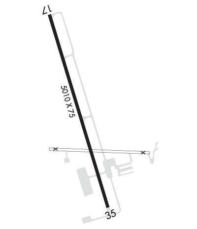
    Runway Identifications
    Runway Identification: 17/35
    Length: 5010 ft
    Width: 75 ft
    Surface: ASPHALT
    Edge lights: Medium Intensity

    Treatment: NONE

     Runway: 17   Runway: 35
    Mag heading: 168°Mag heading: 348°
    Rwy Slope: .39% UpRwy Slope: -.39% Down
    Approach: Approach:
    Pattern: Left TrafficPattern: Left Traffic
    Markings: NONPRECISION INSTRUMENTMarkings: NONPRECISION INSTRUMENT
    Marking Condition: GOODMarking Condition: GOOD
    Arresting Dev: Arresting Dev:
    Lat & Long: N3411.0  W08333.8Lat. & Long.: N3410.2  W08333.6
    Elev: 931.1 ft. MSLElev: 950.5 ft. MSL
    TCH: 56 ft. AGLTCH: 54 ft. AGL
    Visual Glide Path: 3.00 degreesVisual Glide Path: 3.00 degrees
    Displaced Threshold: NoDisplaced Threshold: No
    Touchdown Zone: YESTouchdown Zone: YES
    Touchdown Elev.: 943.1 feetTouchdown Elev.: 950.5 feet
    Visual Glide Slope: 2-Light PAPI on LEFT side of RunwayVisual Glide Slope: 2-Light PAPI on LEFT side of Runway
    RVR Equipment: RVR Equipment:
    RVV Equipment: NORVV Equipment: NO
    Approach Lights: Approach Lights:
    REIL: NOREIL: NO
    Centerline Lights: NOCenterline Lights: NO
    Touchdown lights: NOTouchdown lights: NO
    Runway Category: Runway with a Non-precision Approach having visibility minimums greater than 3/4 mileRunway Category: D
    Declared Distances: Declared Distances:
    Obstructions: TREESObstructions: TREES
    Marked: NOT Marked/LightedMarked: NOT Marked/Lighted
    Clearance slope: CTLNG OBSTN EXCEEDS A 45 DEG SLP.Clearance slope: 10:1
    Obstruction height: 31 feet AGLObstruction height: 84 feet AGL
    Dist. from runway: 211 feetDist. from runway: 1040 feet
    Centerline offset: 479 right of centerlineCenterline offset: 294 feet right of centerline
    Comments: TREES 275 FT RIGHT BTN EOR AND 200 FT FROM EOR.Comments:
    C:4/P: