KJAX

JACKSONVILLE INTL
JACKSONVILLE
FL
Time Zone: Eastern
Lat: N 3029.6
Long: W 08141.3
Elev: 30
Var: +06
Longest Runway: 10000
Clr Del: 119.5
Dept. ATIS: 125.85
Arr. ATIS: 125.85
Ground: 121.9
Tower: 118.3

FBO & Flight Services info for KJAX

FBOs: Update your Fuel Prices

SHELTAIRPh: 904-741-0904 Fax: 904-741-3233 Freq: 130.8
Service
Jet
100LL
SAF
MoGas
Fuel Avail: 0500-2300, after-hours fees apply
Full6.547.22    Last Update: 04/09/2024 07:31
PRICES GUARANTEED by FBO.
Self        
 Address: 14600 WHIRLWIND AVE.   JACKSONVILLE, FL 32218
SIGNATUREPh: 904-741-2201 Fax: 904-741-2250 Freq: 132.0
Service
Jet
100LL
SAF
MoGas
Fuel Avail: PRIST +$0.06/gal.
Full6.646.70    Last Update: 04/19/2024 07:53

subject to change
Self        
 Address: 14700 YONGE DRIVE,   JACKSONVILLE, FLORIDA 32218
ASOSPh: 904-741-4304
-
-
 
If you are an FBO, call 1-203-262-1700 to update your info or email: FltPlan.Advertising@garmin.com
Advertise your FBO on FltPlan.com

Runway & Approach Info for KJAX
Rwy
Length
Land Dist**
Approach*
  Rwy
Length
Land Dist**
Approach*
08
10000x150  10000'          
ILS
 110.70 - 076°  
  
26
  10000x150  10000'          
ILS
 110.30 - 256°  
14
7701x150  7701'          
ILS
 110.50 - 136°  
  
32
  7701x150  7701'          
 
 * only ILS, LOC, LDA, and SDF approaches to a specific runway are shown
** For any Declared Landing Distance Available, please see A/FD or Approach plates
Runway Weight Capability (lbs.) Help
Runway IDSingle WheelDouble WheelDouble Tandem WheelDual Double Wheel
08/26120,000250,000485,0001,005,000
14/32120,000250,000480,0001,000,000
These numbers are Advisory and are not limits.   The Airport Manager should have more accurate Weight Limits
Approach Charts
Approaches    
Current Weather/Notams
Customs Information Send updates to Support@FltPlan.com
Phone 904-714-3100
Fax 904-714-3301

Comments Mon-Fri 0800-1700 1 hr advance notice required *Maximum passengers per flight: 10 *Call prior to 1700 on preceding weekday. *Weekend arrivals call prior to 1700 on preceding Friday. Landing rights and overflight required. *904-751-2827 has ext. 3 *After hours call 904-360-5020
Database effective 04/18/2024
Airport Diagram of KJAX
Airport Diagram might not be current.

Facility Name: JACKSONVILLE INTL
City Name: JACKSONVILLE
County: DUVAL
State abbrev: FL
State Name: FLORIDA
   
Ownership: PUBLICLY OWNED
Use: OPEN TO THE PUBLIC
Owner's Name: JACKSONVILLE INTL AIRPORT
Address: 14201 PECAN PARK ROAD
 JACKSONVILLE, FL 32218
Owner's Phone: 904-741-2000
  
Manager's Name: MR. TERRY DLUGOS
Address: 14201 PECAN PARK ROAD
 JACKSONVILLE, FL 32218
Phone: (904) 741-3866
   
FAA Region: SOUTHERN
FAA Field Office: ORL


Sunrise / Sunset times for JACKSONVILLE INTL

DateSunriseSunset
04/19/24 Friday6:5419:58
04/20/24 Saturday6:5319:58
04/21/24 Sunday6:5219:59
04/22/24 Monday6:5120:00
04/23/24 Tuesday6:5020:00
04/24/24 Wednesday6:4920:01
04/25/24 Thursday6:4820:01
04/26/24 Friday6:4720:02
04/27/24 Saturday6:4620:03
04/28/24 Sunday6:4520:03
04/29/24 Monday6:4420:04
04/30/24 Tuesday6:4320:05
05/01/24 Wednesday6:4220:05
05/02/24 Thursday6:4220:06

Airport Facilities

Airport Attendance ScheduleCONTINUOUS
Airport Status OPERATIONAL (This Status can change at any time - please check NOTAMS)
Airport Lighting ScheduleSS-SR
Airport Storage AvailableTie Downs, Hanger
Extra Services AvailableAir Freight, Avionics, Cargo Handling, Charter, Annual Surveying
Wind IndicatorYES - (lighted)
Control TowerYES
CTAF Frequency
Unicom Frequency122.950
Rotating Beacon ColorWG
Segmented CircleYES
Landing FeeNO

Airport Inspection Data

Airport InspectedFEDERAL - performed by FAA AIRPORTS FIELD PERSONNEL
Inspection Date04/06/2023

Airport Services

Type of Fuel AvailableGrade 100LL, JET A (freeze point -40C)
Airframe Repair ServiceMAJOR
Power Plant Repair ServiceMINOR

Geographic Data

LatitudeN3029.6
LongitudeW08141.3 (ESTIMATED)
Arpt Elevation29ft (SURVEYED)
Magnetic Variation06W
9 miles Nof JACKSONVILLE
Traffic Pattern Altitude
Sectional ChartJACKSONVILLE

Aircraft Data

Operations (Reported)YearlyAvg. Daily
General Aviation Transient 1467440
General Aviation Local 440212
Air Taxi 1351337
Commerical 62575171
Commuter 00
Military 445212
Aircraft based on Field
General Aviation Singles 3
General Aviation Multi 3
Jet Aircraft 46
General Aviation Helicopters 0
Military Aircraft 20
Gliders 0
Ultralights 0

FAA Services

FSS on field NO
FSS tie-in GAINESVILLE
FSS Phone 1-800-WX-BRIEF
Who issues Notams JAX
Notam D service at airport YES
ARTCC Name JACKSONVILLE

Federal Status

Airport CertificationAIRPORT RECEIVING SCHEDULED AIR CARRIER SERVICE FROM CARRIERS CERTIFICATED BY THE CIVIL AERONAUTICS BOARD; PPR 24 HRS FOR UNSKED ACR OPNS WITH MORE THAN 30 PSGR SEATS CALL AMGR 904-741-2020.
Aircraft Rescue & Firefighting IndexAIRPORT HAS A CERTIFICATE UNDER CFR PART 139
Airport of EntryNo
Custom Landing RightsYES
Joint Civil/MilitaryNo
Military Landing rightsYES

Federal Agreements

NATIONAL PLAN OF INTEGRATED AIRPORT SYSTEMS (NPIAS)
GRANT AGREEMENTS UNDER FAAP/ADAP/AIP
ASSURANCES PURSUANT TO TITLE VI, CIVIL RIGHTS ACT OF 1964

Remarks

BIRD ACTIVITY INVOF ARPT, WILDLIFE PRESENTLY ON AIRFIELD.
NON-LOAD BEARING ASPHALT ON WEST AIR CARRIER RAMP BTWN OUTER HIGH MAST LIGHTS AND TERMINAL. AIRCRAFT RQRD TO MAINTAIN TAXI OPS OVER CTRLN ON THE AIR CARRIER RAMP.
PPR FOR HIGH POWER JET ENGINE RUN UPS CTC APT OPS AT 904-741-2020.
MILITARY: ANG: OPR DAYS VARY. BASE OPS 1130-2100Z++. OFFL BUS ONLY. PPR FOR ALL TRAN AFCT (CALL FANG OPS) DSN 641-7122/40/25,C 904-741-7122/40/25. PPR NEEDED TO PROCD ON TWY M1, M2, M3 FANG MAIN RAMP AND ALERT RAMP. PPR NO RESTRD TO ONLY 1 HR EARLIER OR LTR THAN APVL TIME, BFR/AFT THOSE TIMES THE NO IS NOT VALID. TRAN SVCS UNAVBL. FOR CURRENT BWC CTC SOF (FANG OPS) 251.25. BASH PHASE II 1 NOV THRU 31 MAR FOR MIGRATORY BIRD ACT. FOR MORE DTLD INFO SEE AP/1.
ARPT CLSD TO ACFT WINGSPAN MORE THAN 171 FT EXC 6 HR PPR 904-741-2020.
ALL ACFT WITH WINGSPAN GREATER THAN 118FT MUST PERFORM JUDGMENTAL OVERSTEERING INSTEAD OF COCKPIT OVER CENTERLINE STEERING WHEN TAXIING.
TWY ALL AIRCRAFT WITH WINGSPAN GREATER THAN 118FT MUST PERFORM JUDGEMENTAL OVERSTEERING INSTEAD OF COCKPIT OVER CENTERLINE STEERING WHEN TAXIING.
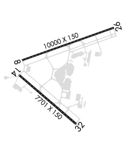
BAK-14 CABLE RAISED FOR TAILHOOK ENGAGEMENT BY TWR ON PILOT REQ ONLY, 1537 FT FM AER 08 AND 1612 FT FM AER 26.
ARPT CLSD TO INTL GEN AVIATION ARR EXE 6HR PPR ARPT OPS AT 904-741-2020 & CTC U. S. CUSTOMS & SERVICING FBO FOR PROCESSING & INSTRUCTIONS.
RADIO CONTROLLED ACFT ACTIVITY 3.5 NM 'NNW' OF ARPT.
SMALL PORTION OF TERMINAL RAMP NOT VISIBLE FM TWR. TWR UNABLE TO DETERMINE IF RAMP IS CLEAR.
Airport Communications & Frequencies:
ATIS Frequencies:   Hours(local) of Operation: CONTINUOUS
125.85
JACKSONVILLE TOWER Tower Frequencies:   Hours(local) of operation: CONTINUOUS   
118.3
317.7
JACKSONVILLE TOWER Ground Frequencies:
121.9
348.6
Clearance Delivery Frequencies:
119.5
290.275
348.6
Emergency Frequencies:
121.5
243.0
Unicom Frequency:
122.950
JACKSONVILLE Primary Approach Frequencies:   Hours(local) of operation: CONTINUOUS   
119.0
121.3 ;ABV 6000 FT
124.9 ;091-180 5000 FT & BLW
127.0 ;270-090
127.775 ;181-269
132.775 ;091-180 ABV 5000 FT
269.9
284.6 ;091-180 ABV 5000 FT
292.15 ;270-090
308.4 ;091-180 5000 FT & BLW
377.075 ;181-269
Part-time Approach Frequencies:  
119.0 ;270-090
269.9 ;270-090
JACKSONVILLE Primary Departure Frequencies:   Hours(local) of operation: CONTINUOUS   
119.0
121.3 ;ABV 6000 FT
124.9 ;091-180 5000 FT & BLW
127.0 ;270-090
127.775 ;181-269
132.775 ;091-180 ABV 5000 FT
269.9
284.6 ;091-180 ABV 5000 FT
292.15 ;270-090
308.4 ;091-180 5000 FT & BLW
377.075 ;181-269
Part-time Departure Frequencies:  
119.0 ;270-090
269.9 ;270-090
Class C Frequencies:
119.0 ;270-090
124.9 ;091-180 5000 FT & BLW
127.0 ;270-090
127.775 ;181-269
132.775 ;091-180 ABV 5000 FT
269.9 ;270-090
284.6 ;091-180 ABV 5000 FT
292.15 ;270-090
308.4 ;091-180 5000 FT & BLW
377.075 ;181-269
Runway Identifications
Runway Identification: 08/26
Length: 10000 ft
Width: 150 ft
Surface: CONCRETE-GOOD CONDITION
Edge lights: High Intensity

Treatment: GROOVED
Weight: PCN 76 /R/B/W/T

 Runway: 08   Runway: 26
Mag heading: 77°Mag heading: 257°
Rwy Slope: -.03% DownRwy Slope: .03% Up
Approach: ILSApproach: ILS
Pattern: Left TrafficPattern: Left Traffic
Markings: PRECISION INSTRUMENTMarkings: PRECISION INSTRUMENT
Marking Condition: FAIRMarking Condition: FAIR
Arresting Dev: BAK-14; BAK-14 BAK-12B(B) (1537 FT).Arresting Dev: BAK-14; BAK-14 BAK-12B-(B) (1612 FT)
Lat & Long: N3029.8  W08142.0Lat. & Long.: N3030.3  W08140.2
Elev: 29.4 ft. MSLElev: 26.4 ft. MSL
TCH: 70 ft. AGLTCH: 70 ft. AGL
Visual Glide Path: 3.00 degreesVisual Glide Path: 3.00 degrees
Displaced Threshold: NoDisplaced Threshold: No
Touchdown Zone: YESTouchdown Zone: YES
Touchdown Elev.: 29.6 feetTouchdown Elev.: 27.0 feet
Visual Glide Slope: 4-Light PAPI on LEFT side of RunwayVisual Glide Slope: 4-Light PAPI on RIGHT side of Runway
RVR Equipment: TOUCHDOWN-MIDFIELD-ROLLOUTRVR Equipment: TOUCHDOWN-MIDFIELD-ROLLOUT
RVV Equipment: NORVV Equipment: NO
Approach Lights: ALSF2 - standard 2,400 foot high intensity approach lighting system with sequenced flashers, Category II or IIIApproach Lights: MALSR - 1,400 foot medium intensity approach lighting system with runway alignment indicator lights
REIL: NOREIL: NO
Centerline Lights: YESCenterline Lights: YES
Touchdown lights: YESTouchdown lights: YES
Runway Category: Precision Instrument RunwayRunway Category: Precision Instrument Runway
Declared Distances: Declared Distances:
Obstructions: TREESObstructions:
Marked: NOT Marked/LightedMarked:
Clearance slope: 50:1Clearance slope: 50:1
Obstruction height: 63 feet AGLObstruction height:
Dist. from runway: 3350 feetDist. from runway:
Centerline offset: 350 right of centerlineCenterline offset:
Comments: Comments:
Runway Identification: 14/32
Length: 7701 ft
Width: 150 ft
Surface: CONCRETE-GOOD CONDITION
Edge lights: High Intensity

Treatment: GROOVED
Weight: PCN 88 /R/C/W/T

 Runway: 14   Runway: 32
Mag heading: 137°Mag heading: 317°
Rwy Slope: -.04% DownRwy Slope: .04% Up
Approach: ILSApproach:
Pattern: Left TrafficPattern: Left Traffic
Markings: PRECISION INSTRUMENTMarkings: PRECISION INSTRUMENT
Marking Condition: GOODMarking Condition: GOOD
Arresting Dev: Arresting Dev:
Lat & Long: N3029.5  W08142.1Lat. & Long.: N3028.7  W08140.9
Elev: 26.9 ft. MSLElev: 24.0 ft. MSL
TCH: 70 ft. AGLTCH: 67 ft. AGL
Visual Glide Path: 3.00 degreesVisual Glide Path: 3.00 degrees
Displaced Threshold: NoDisplaced Threshold: No
Touchdown Zone: YESTouchdown Zone: YES
Touchdown Elev.: 26.9 feetTouchdown Elev.: 24.0 feet
Visual Glide Slope: 4-Light PAPI on LEFT side of RunwayVisual Glide Slope: 4-Light PAPI on LEFT side of Runway
RVR Equipment: RVR Equipment:
RVV Equipment: NORVV Equipment: NO
Approach Lights: MALSR - 1,400 foot medium intensity approach lighting system with runway alignment indicator lightsApproach Lights:
REIL: NOREIL: YES
Centerline Lights: YESCenterline Lights: YES
Touchdown lights: YESTouchdown lights: NO
Runway Category: Precision Instrument RunwayRunway Category: Runway with a Non-precision Approach having visibility minimums greater than 3/4 mile
Declared Distances: Declared Distances:
Obstructions: TREESObstructions: TREES
Marked: NOT Marked/LightedMarked: NOT Marked/Lighted
Clearance slope: 50:1Clearance slope: 45:1
Obstruction height: 50 feet AGLObstruction height: 68 feet AGL
Dist. from runway: 2735 feetDist. from runway: 3290 feet
Centerline offset: 235 right of centerlineCenterline offset:
Comments: Comments:
C:166/P: