Click here for more info on on SMS!

KJAN

JACKSON-EVERS INTL
JACKSON
MS
Time Zone: Central
Lat: N 3218.7
Long: W 09004.6
Elev: 346
Var: +01
Longest Runway: 8500
Dept. ATIS: 121.05
Arr. ATIS: 121.05
Ground: 121.7
Tower: 120.9

FBO & Flight Services info for KJAN

FBOs: Update your Fuel Prices
Atlantic Aviation is your premier aviation service provider with more than 100 locations in North America, including Hawaii and the Caribbean. We provide standard ground services you'd expect, with a detailed focus on ensuring an unforgettable customer experience.
Ph: 601-939-9366 Fax: 601-932-0519 Freq: 122.95WebsiteE-Mail
                     
Service
Jet
100LL
SAF
MoGas
Full7.267.14    Last Update: 04/25/2024 13:10:33

Self        
Misc. Info: All prices are 'Out The Door', call for volume discountsAddress: 120 N. HANGAR DRIVE   JACKSON, MS 39208

ASOSPh: 601-932-2822
-
-
 
If you are an FBO, call 1-203-262-1700 to update your info or email: FltPlan.Advertising@garmin.com
Advertise your FBO on FltPlan.com

Runway & Approach Info for KJAN
Rwy
Length
Land Dist**
Approach*
  Rwy
Length
Land Dist**
Approach*
16L
8500x150  8500'          
ILS
 110.50 - 158°  
  
34R
  8500x150  8500'          
 
16R
8500x150  8500'          
 
  
34L
  8500x150  8500'          
ILS
 109.30 - 338°  
 * only ILS, LOC, LDA, and SDF approaches to a specific runway are shown
** For any Declared Landing Distance Available, please see A/FD or Approach plates
Runway Weight Capability (lbs.) Help
Runway IDSingle WheelDouble WheelDouble Tandem WheelDual Double Wheel
16L/34R75,000200,000390,000850,000
16R/34L130,000140,000250,000720,000
These numbers are Advisory and are not limits.   The Airport Manager should have more accurate Weight Limits
Approach Charts
Approaches    
Current Weather/Notams
Customs Information Send updates to Support@FltPlan.com
Phone 601-932-3324
Fax 601-932-4114

Comments 4 hrs advance notice required. Business hrs 0800-1600 Monday-Friday.
Database effective 05/16/2024
Airport Diagram of KJAN
Airport Diagram might not be current.

Facility Name: JACKSON-MEDGAR WILEY EVERS INTL
City Name: JACKSON
County: RANKIN
State abbrev: MS
State Name: MISSISSIPPI
   
Ownership: PUBLICLY OWNED
Use: OPEN TO THE PUBLIC
Owner's Name: CITY OF JACKSON
Address: P.O. BOX 98109
 JACKSON, MS 39298-8109
Owner's Phone: 601-939-5631
  
Manager's Name: AUSTIN JENKINS
Address: 100 INTERNATIONAL DRIVE, SUITE 300
 JACKSON, MS 39208-8109
Phone: 601-939-5631
   
FAA Region: SOUTHERN
FAA Field Office: JAN
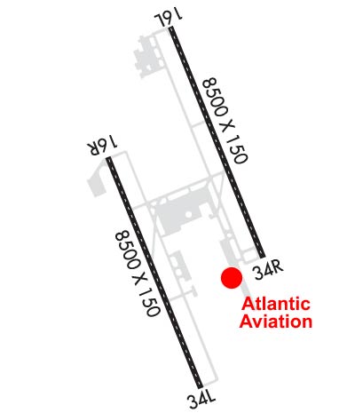

Sunrise / Sunset times for JACKSON-MEDGAR WILEY EVERS INTL

DateSunriseSunset
04/25/24 Thursday6:1919:38
04/26/24 Friday6:1819:38
04/27/24 Saturday6:1719:39
04/28/24 Sunday6:1619:40
04/29/24 Monday6:1519:40
04/30/24 Tuesday6:1419:41
05/01/24 Wednesday6:1319:42
05/02/24 Thursday6:1219:43
05/03/24 Friday6:1119:43
05/04/24 Saturday6:1019:44
05/05/24 Sunday6:1019:45
05/06/24 Monday6:0919:46
05/07/24 Tuesday6:0819:46
05/08/24 Wednesday6:0719:47

Airport Facilities

Airport Attendance ScheduleCONTINUOUS
Airport Status OPERATIONAL (This Status can change at any time - please check NOTAMS)
Airport Lighting ScheduleWHEN TWR CLSD ACTVT MALSR RWY 34L; REIL RWY 16R & 34R; HIRL RWY 16L/34R & 16R/34L - CTAF. RWY 16L ALSF-2 PRESET ON MED INTST EXC SFL NOT AVBL.
Airport Storage AvailableTie Downs, Hanger
Extra Services AvailableAir Ambulance, Avionics, Charter
Wind IndicatorYES - (lighted)
Control TowerYES
CTAF Frequency120.900
Unicom Frequency122.950
Rotating Beacon ColorWG
Segmented CircleYES
Landing FeeLDG FEE FOR NON-COML ACFT OVR 25500 LBS; FEE WAIVED FOR LRGR NON-SKED ACFT WITH SUF FUEL PURCHASE.

Airport Inspection Data

Airport InspectedFEDERAL - performed by FAA AIRPORTS FIELD PERSONNEL
Inspection Date12/08/2023

Airport Services

Type of Fuel AvailableGrade 100LL, JET A (freeze point -40C), JET A
Airframe Repair ServiceMAJOR
Power Plant Repair ServiceMAJOR

Geographic Data

LatitudeN3218.7
LongitudeW09004.6 (ESTIMATED)
Arpt Elevation346ft (SURVEYED)
Magnetic Variation01W
5 miles Eof JACKSON
Traffic Pattern Altitude
Sectional ChartMEMPHIS

Aircraft Data

Operations (Reported)YearlyAvg. Daily
General Aviation Transient 747220
General Aviation Local 10933
Air Taxi 739320
Commerical 1470440
Commuter 00
Military 1825650
Aircraft based on Field
General Aviation Singles 6
General Aviation Multi 11
Jet Aircraft 9
General Aviation Helicopters 0
Military Aircraft 9
Gliders 0
Ultralights 0

FAA Services

FSS on field NO
FSS tie-in GREENWOOD
FSS Phone 1-800-WX-BRIEF
Who issues Notams JAN
Notam D service at airport YES
ARTCC Name MEMPHIS

Federal Status

Airport CertificationAIRPORT RECEIVING SCHEDULED AIR CARRIER SERVICE FROM CARRIERS CERTIFICATED BY THE CIVIL AERONAUTICS BOARD
Aircraft Rescue & Firefighting IndexAIRPORT HAS A CERTIFICATE UNDER CFR PART 139
Airport of EntryNo
Custom Landing RightsYES
Joint Civil/MilitaryNo
Military Landing rightsYES

Federal Agreements

NATIONAL PLAN OF INTEGRATED AIRPORT SYSTEMS (NPIAS)
GRANT AGREEMENTS UNDER FAAP/ADAP/AIP
ASSURANCES PURSUANT TO TITLE VI, CIVIL RIGHTS ACT OF 1964

Remarks

BRG STRENGTH RWY 16L/34R & 16R/34L: ST175.
MIL ACFT USE TWY C7 TO ACES THE FBO APRON UNLESS OTRW DRCTD BY ATC.
HOLD AREA 1 & 2 CMSND ON TERM APRON BTN TWY B3 & TWY B5.
FOR CD CTC MEMPHIS ARTCC AT 901-368-8453/8449.
CAUTION - BASH PHASE II PERIOD JULY-OCTOBER. CTC AFLD MGMT OR COMD POST FOR CURRENT BIRD WATCH COND.
MILITARY: ANG: BASH PHASE II IN EFCT 1 JUL-31 OCT. CTC TWR, COMMAND POST OR AFM FOR BIRD HAZ. WILDLIFE MOST ACTV +/- 1 HR OF SS AND SR.
JASU: 8(A/M32A-86D) 3(MC-1A).
MILITARY: ANG: OFFL BUS. ALL TRAN ACFT 48HR PPR. LTD PRK USE. CTC AFLD MGMT. TRAN ACFT USE FBO FOR SVC. AFLD MGMT OPR 1300-0230Z++ WKD, DSN 828-8372, C601-405-8372. COMD POST OPR 1200-0630Z++ WKD, DSN 828-8350, C601-405-8350.
BE ALERT WHEN XNG AER 16R.
RWY 16L/ 34RWT BRG CPTY FOR RWYS 16L/34R & 16R/34L ARE TRT585 TO ACCOMMODATE C-17 ACFT.
Airport Communications & Frequencies:
ATIS Frequencies:   Hours(local) of Operation: CONTINUOUS
121.05
JACKSON Tower Frequencies:   Hours(local) of operation: 1200-0500Z++   
120.9
352.0
JACKSON Ground Frequencies:
121.7
348.6
Emergency Frequencies:
121.5
243.0
CTAF Frequency:
120.900
Unicom Frequency:
122.950
Remarks
  • APCH/DEP SVC PRVDD BY MEMPHIS ARTCC ON FREQS 132.5/259.1 (JACKSON RCAG) WHEN JACKSON APCH CTL CLSD.
  • 172ND AW CP.
  • JACKSON Primary Approach Frequencies:   Hours(local) of operation: 1200-0500Z++   
    123.9 ;333-152
    125.25 ;153-332
    317.7 ;333-152
    319.2 ;153-332
    JACKSON Primary Departure Frequencies:   Hours(local) of operation: 1200-0500Z++   
    123.9 ;333-152
    125.25 ;153-332
    317.7 ;333-152
    319.2 ;153-332
    Class C Frequencies:
    123.9 ;333-152
    125.25 ;153-332
    317.7 ;333-152
    319.2 ;153-332
    Runway Identifications
    Runway Identification: 16L/34R
    Length: 8500 ft
    Width: 150 ft
    Surface: ASPHALT-GOOD CONDITION
    Edge lights: High Intensity

    Treatment: GROOVED
    Weight: PCN 88 /F/C/W/T

     Runway: 16L   Runway: 34R
    Mag heading: 159°Mag heading: 339°
    Rwy Slope: .48% UpRwy Slope: -.48% Down
    Approach: ILSApproach:
    Pattern: Left TrafficPattern: Left Traffic
    Markings: PRECISION INSTRUMENTMarkings: PRECISION INSTRUMENT
    Marking Condition: GOODMarking Condition: GOOD
    Arresting Dev: Arresting Dev:
    Lat & Long: N3219.7  W09004.7Lat. & Long.: N3218.4  W09004.0
    Elev: 305.2 ft. MSLElev: 346.4 ft. MSL
    TCH: 71 ft. AGLTCH: 66 ft. AGL
    Visual Glide Path: 3.00 degreesVisual Glide Path: 3.00 degrees
    Displaced Threshold: NoDisplaced Threshold: No
    Touchdown Zone: YESTouchdown Zone: YES
    Touchdown Elev.: 311.6 feetTouchdown Elev.: 346.4 feet
    Visual Glide Slope: 4-Light PAPI on LEFT side of RunwayVisual Glide Slope: 4-Light PAPI on RIGHT side of Runway
    RVR Equipment: TOUCHDOWN-MIDFIELD-ROLLOUTRVR Equipment: TOUCHDOWN-MIDFIELD-ROLLOUT
    RVV Equipment: YESRVV Equipment: YES
    Approach Lights: ALSF2 - standard 2,400 foot high intensity approach lighting system with sequenced flashers, Category II or IIIApproach Lights:
    REIL: NOREIL: YES
    Centerline Lights: YESCenterline Lights: YES
    Touchdown lights: YESTouchdown lights: NO
    Runway Category: Precision Instrument RunwayRunway Category: Runway with a Non-precision Approach having visibility minimums greater than 3/4 mile
    Declared Distances: Declared Distances:
    Obstructions: TREESObstructions: TREES
    Marked: NOT Marked/LightedMarked: NOT Marked/Lighted
    Clearance slope: 40:1Clearance slope: 50:1
    Obstruction height: 57 feet AGLObstruction height: 51 feet AGL
    Dist. from runway: 2500 feetDist. from runway: 2750 feet
    Centerline offset: 35 left of centerlineCenterline offset: 650 feet right of centerline
    Comments: Comments:
    Runway Identification: 16R/34L
    Length: 8500 ft
    Width: 150 ft
    Surface: ASPHALT
    Edge lights: High Intensity

    Treatment: GROOVED
    Weight: PCN 59 /F/B/X/U

     Runway: 16R   Runway: 34L
    Mag heading: 159°Mag heading: 339°
    Rwy Slope: .28% UpRwy Slope: -.28% Down
    Approach: Approach: ILS
    Pattern: Left TrafficPattern: Left Traffic
    Markings: PRECISION INSTRUMENTMarkings: PRECISION INSTRUMENT
    Marking Condition: GOODMarking Condition: GOOD
    Arresting Dev: Arresting Dev:
    Lat & Long: N3218.9  W09005.1Lat. & Long.: N3217.6  W09004.4
    Elev: 305.0 ft. MSLElev: 328.8 ft. MSL
    TCH: 80 ft. AGLTCH:
    Visual Glide Path: 3.00 degreesVisual Glide Path:
    Displaced Threshold: NoDisplaced Threshold: No
    Touchdown Zone: YESTouchdown Zone: YES
    Touchdown Elev.: 320.0 feetTouchdown Elev.: 329.0 feet
    Visual Glide Slope: 4-Light PAPI on LEFT side of RunwayVisual Glide Slope:
    RVR Equipment: ROLLOUTRVR Equipment: TOUCHDOWN
    RVV Equipment: NORVV Equipment: YES
    Approach Lights: Approach Lights: MALSR - 1,400 foot medium intensity approach lighting system with runway alignment indicator lights
    REIL: YESREIL: NO
    Centerline Lights: YESCenterline Lights: YES
    Touchdown lights: NOTouchdown lights: YES
    Runway Category: Runway with a Non-precision Approach having visibility minimums greater than 3/4 mileRunway Category: Precision Instrument Runway
    Declared Distances: Declared Distances:
    Obstructions: Obstructions: TREES
    Marked: Marked: NOT Marked/Lighted
    Clearance slope: 50:1Clearance slope: 50:1
    Obstruction height: Obstruction height: 78 feet AGL
    Dist. from runway: Dist. from runway: 4100 feet
    Centerline offset: Centerline offset: 700 feet left of centerline
    Comments: Comments:
    C:95/P: