
| ||||||||||||||||||||||||||||||||||||||||||||
| ||||||||||||||||||||||||||||||||||||||||||||
| ||||||||||||||||||||||||||||||||||||||||||||
| FBOs at nearby airports who want your business: | |||||||||||
| |||||||||||
| Rwy | Rwy | |||||||
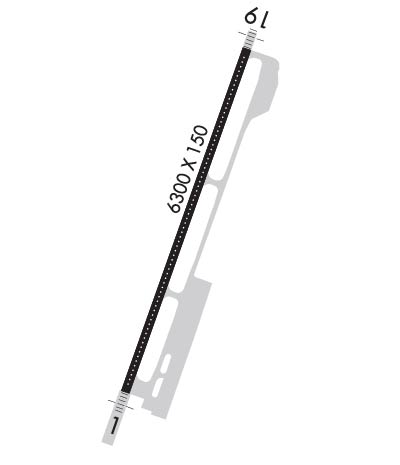
| 6300x150 | 6300' | 6300x150 | 6300' | 109.10 - 186° | ||||
| Runway ID | Single Wheel | Double Wheel | Double Tandem Wheel | Dual Double Wheel |
| 01/19 | 120,000 | 187,000 | 287,000 | N/A |
| These numbers are Advisory and are not limits. The Airport Manager should have more accurate Weight Limits | ||||
 Airport Diagram might not be current. | |
| Facility Name: | JACKSON HOLE |
| City Name: | JACKSON |
| County: | TETON |
| State abbrev: | WY |
| State Name: | WYOMING |
| Ownership: | PUBLICLY OWNED |
| Use: | OPEN TO THE PUBLIC |
| Owner's Name: | JACKSON HOLE AIRPORT BOARD; LEASED FROM U S PARK SERVICE. |
| Address: | P. O. BOX 159 |
| JACKSON, WY 83001 | |
| Owner's Phone: | 307-733-7682 |
| Manager's Name: | JIM ELWOOD |
| Address: | P. O. BOX 159 |
| JACKSON, WY 83001 | |
| Phone: | (307) 733-7695 |
| FAA Region: | NORTHWEST MOUNTAIN |
| FAA Field Office: | DEN |

| Date | Sunrise | Sunset |
|---|---|---|
| 04/24/24 Wednesday | 6:25 | 20:18 |
| 04/25/24 Thursday | 6:23 | 20:19 |
| 04/26/24 Friday | 6:21 | 20:20 |
| 04/27/24 Saturday | 6:20 | 20:22 |
| 04/28/24 Sunday | 6:19 | 20:23 |
| 04/29/24 Monday | 6:17 | 20:24 |
| 04/30/24 Tuesday | 6:16 | 20:25 |
| 05/01/24 Wednesday | 6:14 | 20:26 |
| 05/02/24 Thursday | 6:13 | 20:27 |
| 05/03/24 Friday | 6:12 | 20:29 |
| 05/04/24 Saturday | 6:10 | 20:30 |
| 05/05/24 Sunday | 6:09 | 20:31 |
| 05/06/24 Monday | 6:08 | 20:32 |
| 05/07/24 Tuesday | 6:06 | 20:33 |
| Airport Attendance Schedule | 7 Days A Week 0700-2130; ON CALL H24 PHONE 307-733-4767. |
| Airport Status | OPERATIONAL (This Status can change at any time - please check NOTAMS) |
| Airport Lighting Schedule | WHEN ATCT CLSD ACTVT MALS RWY 01 & 19; HIRL RWY 01/19; RCLS RWY 01/19; TWY LGTS; WDI - CTAF. |
| Airport Storage Available | Tie Downs, Hanger |
| Extra Services Available | Air Freight, Air Ambulance, Charter, Flight Instruction, Aircraft Rental |
| Wind Indicator | YES - (lighted) |
| Control Tower | YES |
| CTAF Frequency | 118.075 |
| Unicom Frequency | 122.950 |
| Rotating Beacon Color | WG |
| Segmented Circle | NO |
| Landing Fee | YES |
| Airport Inspected | FEDERAL - performed by FAA AIRPORTS FIELD PERSONNEL |
| Inspection Date | 06/07/2023 |
| Type of Fuel Available | Grade 100LL, JET A (freeze point -40C) |
| Airframe Repair Service | MINOR |
| Power Plant Repair Service | MINOR |
| Latitude | N4336.4 |
| Longitude | W11044.3 (ESTIMATED) |
| Arpt Elevation | 6450ft (SURVEYED) |
| Magnetic Variation | 13E |
| 7 miles N | of JACKSON |
| Traffic Pattern Altitude | |
| Sectional Chart | SALT LAKE CITY |
| Operations (Reported) | Yearly | Avg. Daily |
|---|---|---|
| General Aviation Transient | 9564 | 26 |
| General Aviation Local | 114 | 0 |
| Air Taxi | 9894 | 27 |
| Commerical | 9103 | 25 |
| Commuter | 0 | 0 |
| Military | 173 | 0 |
| Aircraft based on Field | |
|---|---|
| General Aviation Singles | 13 |
| General Aviation Multi | 2 |
| Jet Aircraft | 5 |
| General Aviation Helicopters | 0 |
| Military Aircraft | 0 |
| Gliders | 0 |
| Ultralights | 0 |
| FSS on field | NO |
| FSS tie-in | CASPER |
| FSS Phone | 1-800-WX-BRIEF |
| Who issues Notams | JAC |
| Notam D service at airport | YES |
| ARTCC Name | SALT LAKE CITY |
| Airport Certification | AIRPORT RECEIVING SCHEDULED AIR CARRIER SERVICE FROM CARRIERS CERTIFICATED BY THE CIVIL AERONAUTICS BOARD |
| Aircraft Rescue & Firefighting Index | AIRPORT HAS A CERTIFICATE UNDER CFR PART 139 |
| Airport of Entry | No |
| Custom Landing Rights | No |
| Joint Civil/Military | No |
| Military Landing rights | YES |
| NATIONAL PLAN OF INTEGRATED AIRPORT SYSTEMS (NPIAS) |
| GRANT AGREEMENTS UNDER FAAP/ADAP/AIP |
| ASSURANCES PURSUANT TO TITLE VI, CIVIL RIGHTS ACT OF 1964 |
| THIS AIRPORT HAS BEEN SURVEYED BY THE NATIONAL GEODETIC SURVEY. |
| 35'-53' TREES 700'-800' WEST OF THR RY 01. |
| PAVED 950X200 FT SAFETY AREA AT THE DEP END OF RWY 19; NOT USBL FOR PER CALCULATIONS; PLOWED & BROOMED DURG WINTER. |
| DEICING PAD LOCATED AT NORTH END OF TWY A. |
| COLD TEMPERATURE AIRPORT. ALTITUDE CORRECTION REQUIRED AT OR BELOW -22C. |
| FOR CD IF UNA TO CTC ON FSS FREQ, CTC JAC TWR GND AT 124.55 DURG NML OPRG HRS. OUTSIDE OF NML OPRG HRS, CTC SALT LAKE ARTCC AT 801-320-2568. |
| ACFT PUSHING BACK FM TRML CAUSE CGSTN, MAKING A2 UNAVBL. COORD RWY EXITS WITH TWR. |
| NOISE ABATEMENT PROCEDURES IN EFFECT FOR ACFT DEPARTURES ON RWY 19. |
| SAGE GROUSE ON & INVOF ARPT APR THRU OCT. |
| POSSIBLE SEVERE WINTER CONDITIONS FROM NOV-APR; NO ARPT INFO OR SNOW REMOVAL GUARANTEED DURING HOURS OF NON ATTENDANCE. 307-733-7682 |
| HANG GLIDING OPNS 9 MILES S OF ARPT NEAR SKI ARE & 9 MILES SSW OF ARPT ALONG THE RIDGE. |
| BALLOON OPERATIONS IN VICINITY OF AIRPORT, W AND SW, MAY-OCT. |
| FOR PUBLIC HEALTH & SAFETY FLIGHTS, CONTACT AMGR @ 307-733-7682. |
| ACFT THAT FAIL TO TOUCH DOWN WITHIN THE FIRST THIRD OF RY 01/19 SOMETIMES FAIL TO STOP ON THE RY AND ARE AT RISK FOR A RY EXCURSION. |
| RWY 01/1 9 PCR VALUE: 508/F/C/X/T. |
Airport Communications & Frequencies:
| |||||||||||||||
| Runway: 01 | Runway: 19 | ||
| Mag heading: | 7° | Mag heading: | 187° |
| Rwy Slope: | .60% Up | Rwy Slope: | -.60% Down |
| Approach: | Approach: | ILS/DME | |
| Pattern: | Left Traffic | Pattern: | Left Traffic |
| Markings: | PRECISION INSTRUMENT | Markings: | PRECISION INSTRUMENT |
| Marking Condition: | GOOD | Marking Condition: | GOOD |
| Arresting Dev: | Arresting Dev: | ||
| Lat & Long: | N4336.0 W11044.5 | Lat. & Long.: | N4336.9 W11044.0 |
| Elev: | 6412.8 ft. MSL | Elev: | 6450.5 ft. MSL |
| TCH: | 50 ft. AGL | TCH: | 53 ft. AGL |
| Visual Glide Path: | 3.00 degrees | Visual Glide Path: | 3.00 degrees |
| Displaced Threshold: | No | Displaced Threshold: | No |
| Touchdown Zone: | YES | Touchdown Zone: | YES |
| Touchdown Elev.: | 6431.2 feet | Touchdown Elev.: | 6450.5 feet |
| Visual Glide Slope: | 4-Light PAPI on LEFT side of Runway | Visual Glide Slope: | 4-Light PAPI on RIGHT side of Runway |
| RVR Equipment: | TOUCHDOWN-MIDFIELD-ROLLOUT | RVR Equipment: | TOUCHDOWN-MIDFIELD-ROLLOUT |
| RVV Equipment: | NO | RVV Equipment: | NO |
| Approach Lights: | MALS - 1,400 foot medium intensity approach lighting system | Approach Lights: | MALS - 1,400 foot medium intensity approach lighting system |
| REIL: | NO | REIL: | NO |
| Centerline Lights: | YES | Centerline Lights: | YES |
| Touchdown lights: | NO | Touchdown lights: | NO |
| Runway Category: | Runway with a Non-precision Approach having visibility minimums greater than 3/4 mile | Runway Category: | Precision Instrument Runway |
| Declared Distances: | TORA:6300' TODA:6300' ASDA:6300' LDA:6300' | Declared Distances: | TORA:6300' TODA:6300' ASDA:6300' LDA:6300' |
| Obstructions: | ROAD | Obstructions: | |
| Marked: | NOT Marked/Lighted | Marked: | |
| Clearance slope: | 5:1 | Clearance slope: | 50:1 |
| Obstruction height: | 10 feet AGL | Obstruction height: | |
| Dist. from runway: | 249 feet | Dist. from runway: | |
| Centerline offset: | 505 left of centerline | Centerline offset: | |
| Comments: | Comments: |