Click here for more info on on SMS!

KIXA

HALIFAX-NORTHAMPTON RGNL
ROANOKE RAPIDS
NC
Time Zone: Eastern
Lat: N 3619.8
Long: W 07738.1
Elev: 144
Var: +10
Longest Runway: 5500
AWOS: 119.97
CTAF: 123.07

FBO & Flight Services info for KIXA

FBOs: Update your Fuel Prices
Our modern terminal building has a spacious lobby and vending area, visitor information center, operations room, offices, conference room, pilot lounge, quiet room and other facilities. These facilities provide comfortable amenities found at many larger airports.
Ph: 252-583-3492
-
Freq: 123.07WebsiteE-Mail
                                       
Service
Jet
100LL
SAF
MoGas
Fuel Avail: PRIST PREMIXED. Assisted/Self Service
Full        Last Update: 04/02/2024 08:13

Self5.705.75    
Misc. Info: Address: 700 GREGORY FARM RD   HALIFAX, NC 27839

ASOSPh: 252-583-3446
-
Freq: 119.97  
If you are an FBO, call 1-203-262-1700 to update your info or email: FltPlan.Advertising@garmin.com
Advertise your FBO on FltPlan.com

Runway & Approach Info for KIXA
Rwy
Length
Land Dist**
Approach*
  Rwy
Length
Land Dist**
Approach*
02
5500x100  5500'          
 
  
20
  5500x100  5500'          
 
 * only ILS, LOC, LDA, and SDF approaches to a specific runway are shown
** For any Declared Landing Distance Available, please see A/FD or Approach plates
Runway Weight Capability (lbs.) Help
Runway IDSingle WheelDouble WheelDouble Tandem WheelDual Double Wheel
02/2045,00065,000N/AN/A
These numbers are Advisory and are not limits.   The Airport Manager should have more accurate Weight Limits
Approach Charts
Approaches    
Current Weather/Notams
Customs Information Send updates to Support@FltPlan.com
Customs Not Available
Database effective 05/16/2024
Airport Diagram of KIXA
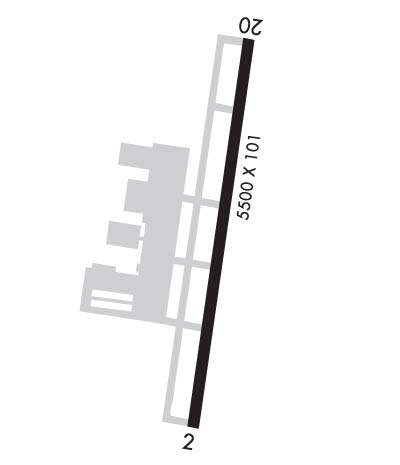
Airport Diagram might not be current.

Facility Name: HALIFAX/NORTHAMPTON RGNL
City Name: ROANOKE RAPIDS
County: HALIFAX
State abbrev: NC
State Name: NORTH CAROLINA
   
Ownership: PUBLICLY OWNED
Use: OPEN TO THE PUBLIC
Owner's Name: HALIFAX-NORTHAMPTON RGNL ARPT AUTH
Address: 10 NORTH KING ST.
 HALIFAX, NC 27839
Owner's Phone: 252-583-1131
  
Manager's Name: FRED DRAPER
Address: 700 GREGORY FARM RD.
 HALIFAX, NC 27839
Phone: 252-583-3492
   
FAA Region: SOUTHERN
FAA Field Office: MEM


Sunrise / Sunset times for HALIFAX/NORTHAMPTON RGNL

DateSunriseSunset
04/25/24 Thursday6:2319:54
04/26/24 Friday6:2219:55
04/27/24 Saturday6:2119:56
04/28/24 Sunday6:2019:56
04/29/24 Monday6:1919:57
04/30/24 Tuesday6:1819:58
05/01/24 Wednesday6:1719:59
05/02/24 Thursday6:1620:00
05/03/24 Friday6:1420:01
05/04/24 Saturday6:1320:02
05/05/24 Sunday6:1220:02
05/06/24 Monday6:1120:03
05/07/24 Tuesday6:1020:04
05/08/24 Wednesday6:0920:05

Airport Facilities

Airport Attendance ScheduleSUN 1200-1700, MON-SAT 0800-1700; UNATNDD NEW YEARS DAY, EASTER, JULY 4, THANKSGIVING, CHRISTMAS.
Airport Status OPERATIONAL (This Status can change at any time - please check NOTAMS)
Airport Lighting ScheduleACTVT MALSR RWY 20; REIL RWY 02; PAPI RWY 02 & 20; HIRL RWY 02/20 - CTAF.
Airport Storage AvailableTie Downs
Extra Services AvailableNONE
Wind IndicatorYES - (lighted)
Control TowerNO
CTAF Frequency123.075
Unicom Frequency123.075
Rotating Beacon ColorWG
Segmented CircleYES
Landing Fee

Airport Inspection Data

Airport InspectedSTATE - performed by STATE AERONAUTICAL PERSONNEL
Inspection Date05/31/2021

Airport Services

Type of Fuel AvailableGrade 100LL, JET A-1 (icing inhibitor, freeze point -50C); -10100LL AND JET-A FUEL AVBL 24 HRS SELF SERVICE W/ CREDIT CARD.
Airframe Repair ServiceNone
Power Plant Repair ServiceNone

Geographic Data

LatitudeN3619.8
LongitudeW07738.1 (ESTIMATED)
Arpt Elevation144ft (SURVEYED)
Magnetic Variation10W
8 miles Sof ROANOKE RAPIDS
Traffic Pattern Altitude
Sectional ChartWASHINGTON

Aircraft Data

Operations (Reported)YearlyAvg. Daily
General Aviation Transient 940026
General Aviation Local 1120031
Air Taxi 00
Commerical 00
Commuter 00
Military 3001
Aircraft based on Field
General Aviation Singles 21
General Aviation Multi 4
Jet Aircraft 0
General Aviation Helicopters 0
Military Aircraft 0
Gliders 0
Ultralights 0

FAA Services

FSS on field NO
FSS tie-in RALEIGH
FSS Phone 1-800-WX-BRIEF
Who issues Notams IXA
Notam D service at airport YES
ARTCC Name WASHINGTON

Federal Status

Airport Certification
Aircraft Rescue & Firefighting IndexNone
Airport of EntryNo
Custom Landing RightsNo
Joint Civil/MilitaryNo
Military Landing rightsNo

Federal Agreements

NATIONAL PLAN OF INTEGRATED AIRPORT SYSTEMS (NPIAS)
GRANT AGREEMENTS UNDER FAAP/ADAP/AIP
ASSURANCES PURSUANT TO TITLE VI, CIVIL RIGHTS ACT OF 1964

Remarks

BIRDS ON & INVOF ARPT.
AGRICULTURE EQUIP OCNLY ADJ TO RWY 02/20.
FOR CD CTC WASHINGTON ARTCC AT 703-771-3587.
Airport Communications & Frequencies:
CTAF Frequency:
123.075
Unicom Frequency:
123.075
Remarks
  • APCH/DEP SVC PRVDD BY WASHINGTON ARTCC ON FREQS 132.025/290.425 (LAWRENCEVILLE RCAG).
  • Runway Identifications
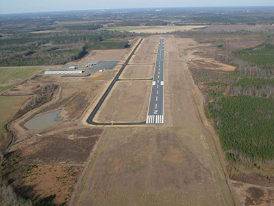
    Runway Identification: 02/20
    Length: 5500 ft
    Width: 100 ft
    Surface: ASPHALT
    Edge lights: High Intensity

    Treatment: NONE

     Runway: 02   Runway: 20
    Mag heading: 19°Mag heading: 199°
    Rwy Slope: -.03% DownRwy Slope: .03% Up
    Approach: Approach:
    Pattern: Left TrafficPattern: Left Traffic
    Markings: NONPRECISION INSTRUMENTMarkings: PRECISION INSTRUMENT
    Marking Condition: GOODMarking Condition: GOOD
    Arresting Dev: Arresting Dev:
    Lat & Long: N3619.3  W07738.2Lat. & Long.: N3620.2  W07738.0
    Elev: 140.7 ft. MSLElev: 138.8 ft. MSL
    TCH: 25 ft. AGLTCH: 24 ft. AGL
    Visual Glide Path: 3.00 degreesVisual Glide Path: 3.00 degrees
    Displaced Threshold: NoDisplaced Threshold: No
    Touchdown Zone: YESTouchdown Zone: YES
    Touchdown Elev.: 143.8 feetTouchdown Elev.: 144.3 feet
    Visual Glide Slope: 2-Light PAPI on LEFT side of RunwayVisual Glide Slope: 2-Light PAPI on LEFT side of Runway
    RVR Equipment: RVR Equipment:
    RVV Equipment: NORVV Equipment: NO
    Approach Lights: Approach Lights: MALSR - 1,400 foot medium intensity approach lighting system with runway alignment indicator lights
    REIL: YESREIL: NO
    Centerline Lights: NOCenterline Lights: NO
    Touchdown lights: NOTouchdown lights: NO
    Runway Category: Runway with a Non-precision Approach having visibility minimums greater than 3/4 mileRunway Category: D
    Declared Distances: Declared Distances:
    Obstructions: TREESObstructions: TREES
    Marked: NOT Marked/LightedMarked: NOT Marked/Lighted
    Clearance slope: 35:1Clearance slope: 31:1
    Obstruction height: 20 feet AGLObstruction height: 44 feet AGL
    Dist. from runway: 906 feetDist. from runway: 1596 feet
    Centerline offset: 490 left of centerlineCenterline offset: 126 feet left of centerline
    Comments: 22 FT TREES 0-200 FT FR THR OFFSET 320 L OF CNTRLN AND 42 FT TREES 0-200 FT FR THR OFFSET 367 R OF CNTRLN.Comments:
    C:3/P: