
| ||||||||||||||||||||||||||||||||||||||||||||||||||||||||||||||||||||
| ||||||||||||||||||||||||||||||||||||||||||||||||||||||||||||||||||||
| ||||||||||||||||||||||||||||||||||||||||||||||||||||||||||||||||||||
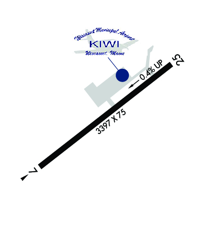
| Rwy | Rwy | |||||||
| 3397x75 | 3397' | 3397x75 | 3397' | |||||
| Runway ID | Single Wheel | Double Wheel | Double Tandem Wheel | Dual Double Wheel |
| 07/25 | 22,000 | N/A | N/A | N/A |
| These numbers are Advisory and are not limits. The Airport Manager should have more accurate Weight Limits | ||||
 Airport Diagram might not be current. | |
| Facility Name: | WISCASSET |
| City Name: | WISCASSET |
| County: | LINCOLN |
| State abbrev: | ME |
| State Name: | MAINE |
| Ownership: | PUBLICLY OWNED |
| Use: | OPEN TO THE PUBLIC |
| Owner's Name: | TOWN OF WISCASSET |
| Address: | 51 BATH RD |
| WISCASSET, ME 04578 | |
| Owner's Phone: | (207) 882-8200 |
| Manager's Name: | RICK TETREV |
| Address: | 96 CHEWONKI NECK ROAD, 51 BATH RD |
| WISCASSET, ME 04578 | |
| Phone: | (207) 882-5475; EMAIL: AIRPORT@WISCASSET.ORG. EMERG CTC: 207-882-8202 (TOWN DISPATCHER). |
| FAA Region: | NEW ENGLAND |
| FAA Field Office: | NONE |
| Date | Sunrise | Sunset |
|---|---|---|
| 04/18/24 Thursday | 5:49 | 19:27 |
| 04/19/24 Friday | 5:48 | 19:29 |
| 04/20/24 Saturday | 5:46 | 19:30 |
| 04/21/24 Sunday | 5:45 | 19:31 |
| 04/22/24 Monday | 5:43 | 19:32 |
| 04/23/24 Tuesday | 5:41 | 19:33 |
| 04/24/24 Wednesday | 5:40 | 19:35 |
| 04/25/24 Thursday | 5:38 | 19:36 |
| 04/26/24 Friday | 5:37 | 19:37 |
| 04/27/24 Saturday | 5:35 | 19:38 |
| 04/28/24 Sunday | 5:34 | 19:39 |
| 04/29/24 Monday | 5:32 | 19:41 |
| 04/30/24 Tuesday | 5:31 | 19:42 |
| 05/01/24 Wednesday | 5:30 | 19:43 |
| Airport Attendance Schedule | JAN-MAR NOT ATTENDED, DEC-APR SAT-SUN 1000-1400, MAY-LABOR DAY 7 Days A Week 0800-1600, SEP-NOV FRI-SUN 0900-1600 |
| Airport Status | OPERATIONAL (This Status can change at any time - please check NOTAMS) |
| Airport Lighting Schedule | ACTVT REIL RWY 25; PAPI RWY 07 & 25; MIRL RWY 07/25 - CTAF. |
| Airport Storage Available | Tie Downs, Hanger |
| Extra Services Available | Charter |
| Wind Indicator | YES - (lighted) |
| Control Tower | NO |
| CTAF Frequency | 122.800 |
| Unicom Frequency | 122.800 |
| Rotating Beacon Color | WG |
| Segmented Circle | YES |
| Landing Fee | NO |
| Airport Inspected | STATE - performed by PRIVATE CONTRACT PERSONNEL |
| Inspection Date | 08/16/2023 |
| Type of Fuel Available | Grade 100LL, JET A-1 (icing inhibitor, freeze point -50C); -1024 HR CREDIT CARD FUEL OPN. |
| Airframe Repair Service | NONE |
| Power Plant Repair Service | NONE |
| Latitude | N4357.7 |
| Longitude | W06942.8 (ESTIMATED) |
| Arpt Elevation | 70ft (SURVEYED) |
| Magnetic Variation | 18W |
| 3 miles SW | of WISCASSET |
| Traffic Pattern Altitude | |
| Sectional Chart | NEW YORK |
| Operations (Reported) | Yearly | Avg. Daily |
|---|---|---|
| General Aviation Transient | 3100 | 8 |
| General Aviation Local | 3800 | 10 |
| Air Taxi | 275 | 1 |
| Commerical | 0 | 0 |
| Commuter | 0 | 0 |
| Military | 25 | 0 |
| Aircraft based on Field | |
|---|---|
| General Aviation Singles | 29 |
| General Aviation Multi | 1 |
| Jet Aircraft | 0 |
| General Aviation Helicopters | 1 |
| Military Aircraft | 0 |
| Gliders | 0 |
| Ultralights | 0 |
| FSS on field | NO |
| FSS tie-in | BANGOR |
| FSS Phone | 1-800-WX-BRIEF |
| Who issues Notams | IWI |
| Notam D service at airport | YES |
| ARTCC Name | BOSTON |
| Airport Certification | |
| Aircraft Rescue & Firefighting Index | None |
| Airport of Entry | No |
| Custom Landing Rights | No |
| Joint Civil/Military | No |
| Military Landing rights | YES |
| NATIONAL PLAN OF INTEGRATED AIRPORT SYSTEMS (NPIAS) |
| GRANT AGREEMENTS UNDER FAAP/ADAP/AIP |
| ASSURANCES PURSUANT TO TITLE VI, CIVIL RIGHTS ACT OF 1964 |
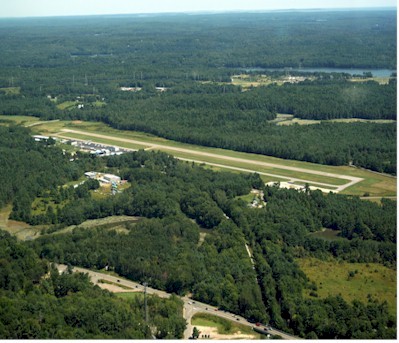
| NOISE SENSITIVE AREA SOUTHWEST OFF EOR 07, CLIMB STRAIGHT OUT TO 700 FT AGL. |
| DEER AND WILDLIFE ON & INVOF ARPT. |
| RWY 7 APCH OBSTN LGTS ON 60 FT. POLES ALG RIGHT SIDE OF APCH LCTD IN 60 FT. TO 70 FT. TALL TREES. |
| FOR CD CTC PORTLAND APCH AT 207-874-7320. WHEN PORTLAND APCH CLSD, CTC BOSTON ARTCC AT 603-879-6859. |
Airport Communications & Frequencies:
| |||||||||||||||||||||||||
| Runway: 07 | Runway: 25 | ||
| Mag heading: | 70° | Mag heading: | 250° |
| Rwy Slope: | -.42% Down | Rwy Slope: | .42% Up |
| Approach: | Approach: | ||
| Pattern: | Left Traffic | Pattern: | Right Traffic |
| Markings: | NONPRECISION INSTRUMENT | Markings: | NONPRECISION INSTRUMENT |
| Marking Condition: | GOOD | Marking Condition: | GOOD |
| Arresting Dev: | Arresting Dev: | ||
| Lat & Long: | N4357.5 W06943.1 | Lat. & Long.: | N4357.9 W06942.5 |
| Elev: | 70.1 ft. MSL | Elev: | 55.8 ft. MSL |
| TCH: | 40 ft. AGL | TCH: | 40 ft. AGL |
| Visual Glide Path: | 4.00 degrees | Visual Glide Path: | 3.50 degrees |
| Displaced Threshold: | No | Displaced Threshold: | No |
| Touchdown Zone: | YES | Touchdown Zone: | YES |
| Touchdown Elev.: | 70.2 feet | Touchdown Elev.: | 67.3 feet |
| Visual Glide Slope: | 4-Light PAPI on RIGHT side of Runway | Visual Glide Slope: | 4-Light PAPI on LEFT side of Runway |
| RVR Equipment: | RVR Equipment: | ||
| RVV Equipment: | NO | RVV Equipment: | NO |
| Approach Lights: | Approach Lights: | ||
| REIL: | NO | REIL: | YES |
| Centerline Lights: | NO | Centerline Lights: | NO |
| Touchdown lights: | NO | Touchdown lights: | NO |
| Runway Category: | Runway with a Non-precision Approach | Runway Category: | Runway with a Non-precision Approach |
| Declared Distances: | Declared Distances: | ||
| Obstructions: | POLE | Obstructions: | TREE |
| Marked: | LIGHTED | Marked: | NOT Marked/Lighted |
| Clearance slope: | 5:1 | Clearance slope: | 11:1 |
| Obstruction height: | 12 feet AGL | Obstruction height: | 5 feet AGL |
| Dist. from runway: | 262 feet | Dist. from runway: | 255 feet |
| Centerline offset: | 253 right of centerline | Centerline offset: | 200 feet right of centerline |
| Comments: | Comments: | SCRUB BRUSH 60-100 FT FM RWY END, 80-200 FT R; SCRUB BRUSH 20-43 FT FM RWY END, 140-210 FT L. |


