Current Weather/Notams (Metars, TAFs, Notams, NWS Forecast, PIREPS, and nearby weather)
Customs Information Send updates to Support@FltPlan.com
Customs Not Available
Database effective 05/16/2024
Airport Diagram might not be current.
|
| Facility Name: | ALEXANDER FLD SOUTH WOOD COUNTY |
| City Name: | WISCONSIN RAPIDS |
| County: | WOOD |
| State abbrev: | WI |
| State Name: | WISCONSIN |
| | |
| Ownership: | PUBLICLY OWNED |
| Use: | OPEN TO THE PUBLIC |
| Owner's Name: | WISCONSIN RAPIDS; ALSO VILLAGE OF PORT EDWARDS; TOWN OF GRAND RAPIDS, CITY OF NEKOOSA. |
| Address: | 3620 1ST STREET SOUTH |
| | WISCONSIN RAPIDS, WI 54495 |
| Owner's Phone: | (715) 423-0330 |
| | |
| Manager's Name: | JEREMY SICKLER |
| Address: | 3620 1ST ST SOUTH; EMAIL ADDRESS: JSICKLER@WIRAPIDS.ORG (ALL LOWER CASE) |
| | WISCONSIN RAPIDS, WI 54494 |
| Phone: | (715) 423-0330; AFT HRS SVC CALL 715-741-2114 |
| | |
| FAA Region: | GREAT LAKES |
| FAA Field Office: | CHI |
Runway Identifications
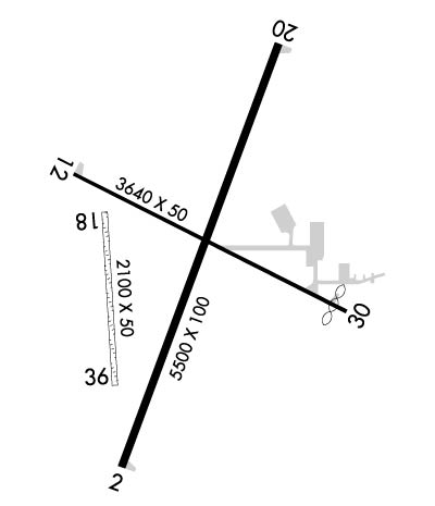
Runway Identification: 02/20Length: 5500 ft
Width: 100 ft
Surface: ASPHALT
Edge lights: Medium IntensityTreatment: NONE
| | Runway: 02 | | Runway: 20 |
| Mag heading: | 21° | Mag heading: | 201° |
| Rwy Slope: | .19% Up | Rwy Slope: | -.19% Down |
| Approach: | SDF | Approach: | |
| Pattern: | Left Traffic | Pattern: | Left Traffic |
| Markings: | NONPRECISION INSTRUMENT | Markings: | NONPRECISION INSTRUMENT |
| Marking Condition: | GOOD | Marking Condition: | GOOD |
| Arresting Dev: | | Arresting Dev: | |
| Lat & Long: | N4421.2 W08950.5 | Lat. & Long.: | N4422.1 W08950.1 |
| Elev: | 1010.8 ft. MSL | Elev: | 1021.0 ft. MSL |
| TCH: | 35 ft. AGL | TCH: | 42 ft. AGL |
| Visual Glide Path: | 3.00 degrees | Visual Glide Path: | 3.50 degrees |
| Displaced Threshold: | No | Displaced Threshold: | No |
| Touchdown Zone: | YES | Touchdown Zone: | YES |
| Touchdown Elev.: | 1018.4 feet | Touchdown Elev.: | 1021.0 feet |
| Visual Glide Slope: | 4-Light PAPI on LEFT side of Runway | Visual Glide Slope: | 4-Light PAPI on LEFT side of Runway |
| RVR Equipment: | | RVR Equipment: | |
| RVV Equipment: | NO | RVV Equipment: | NO |
| Approach Lights: | | Approach Lights: | |
| REIL: | YES | REIL: | YES |
| Centerline Lights: | NO | Centerline Lights: | NO |
| Touchdown lights: | NO | Touchdown lights: | NO |
| Runway Category: | Runway with a Non-precision Approach having visibility minimums greater than 3/4 mile | Runway Category: | Runway with a Non-precision Approach having visibility minimums greater than 3/4 mile |
| Declared Distances: | | Declared Distances: | |
| Obstructions: | TREES | Obstructions: | TREE |
| Marked: | NOT Marked/Lighted | Marked: | NOT Marked/Lighted |
| Clearance slope: | 3:1 | Clearance slope: | 20:1 |
| Obstruction height: | 15 feet AGL | Obstruction height: | 68 feet AGL |
| Dist. from runway: | 250 feet | Dist. from runway: | 1560 feet |
| Centerline offset: | 215 right of centerline | Centerline offset: | 330 feet left of centerline |
| Comments: | | Comments: | |
Runway Identification: 12/30Length: 3470 ft
Width: 60 ft
Surface: ASPHALT
Edge lights: Medium IntensityTreatment: NONE
| | Runway: 12 | | Runway: 30 |
| Mag heading: | 117° | Mag heading: | 297° |
| Rwy Slope: | -.24% Down | Rwy Slope: | .24% Up |
| Approach: | | Approach: | |
| Pattern: | Left Traffic | Pattern: | Left Traffic |
| Markings: | NONPRECISION INSTRUMENT | Markings: | NONPRECISION INSTRUMENT |
| Marking Condition: | GOOD | Marking Condition: | GOOD |
| Arresting Dev: | | Arresting Dev: | |
| Lat & Long: | N4421.8 W08950.7 | Lat. & Long.: | N4421.5 W08949.9 |
| Elev: | 1020.0 ft. MSL | Elev: | 1011.6 ft. MSL |
| TCH: | | TCH: | 51 ft. AGL |
| Visual Glide Path: | | Visual Glide Path: | 4.00 degrees |
| Displaced Threshold: | No | Displaced Threshold: | No |
| Touchdown Zone: | YES | Touchdown Zone: | YES |
| Touchdown Elev.: | 1020.0 feet | Touchdown Elev.: | 1019.0 feet |
| Visual Glide Slope: | | Visual Glide Slope: | 4-Light PAPI on LEFT side of Runway |
| RVR Equipment: | | RVR Equipment: | |
| RVV Equipment: | NO | RVV Equipment: | NO |
| Approach Lights: | | Approach Lights: | |
| REIL: | NO | REIL: | NO |
| Centerline Lights: | NO | Centerline Lights: | NO |
| Touchdown lights: | NO | Touchdown lights: | NO |
| Runway Category: | Runway with a Visual Approach | Runway Category: | Runway with a Visual Approach |
| Declared Distances: | | Declared Distances: | |
| Obstructions: | TREES | Obstructions: | |
| Marked: | NOT Marked/Lighted | Marked: | |
| Clearance slope: | 18:1 | Clearance slope: | 20:1 |
| Obstruction height: | 93 feet AGL | Obstruction height: | |
| Dist. from runway: | 1880 feet | Dist. from runway: | |
| Centerline offset: | 200 right of centerline | Centerline offset: | |
| Comments: | | Comments: | |
Runway Identification: 18/36Length: 2072 ft
Width: 50 ft
Surface: GRASS-FAIR CONDITION
Edge lights: Treatment: NONE
| | Runway: 18 | | Runway: 36 |
| Mag heading: | 177° | Mag heading: | 357° |
| Rwy Slope: | -.05% Down | Rwy Slope: | .05% Up |
| Approach: | | Approach: | |
| Pattern: | Left Traffic | Pattern: | Left Traffic |
| Markings: | | Markings: | |
| Marking Condition: | 18/36 MKD WITH YELLOW METAL TRIANGLES. | Marking Condition: | |
| Arresting Dev: | | Arresting Dev: | |
| Lat & Long: | N4421.7 W08950.6 | Lat. & Long.: | N4421.4 W08950.5 |
| Elev: | 1016.0 ft. MSL | Elev: | 1014.9 ft. MSL |
| TCH: | | TCH: | |
| Visual Glide Path: | | Visual Glide Path: | |
| Displaced Threshold: | No | Displaced Threshold: | No |
| Touchdown Zone: | YES | Touchdown Zone: | YES |
| Touchdown Elev.: | 1016.0 feet | Touchdown Elev.: | 1016.0 feet |
| Visual Glide Slope: | | Visual Glide Slope: | |
| RVR Equipment: | | RVR Equipment: | |
| RVV Equipment: | NO | RVV Equipment: | NO |
| Approach Lights: | | Approach Lights: | |
| REIL: | NO | REIL: | NO |
| Centerline Lights: | NO | Centerline Lights: | NO |
| Touchdown lights: | NO | Touchdown lights: | NO |
| Runway Category: | Runway with a Visual Approach | Runway Category: | Runway with a Visual Approach |
| Declared Distances: | | Declared Distances: | |