Click here for more info on on SMS!

KISB

SIBLEY MUNI
SIBLEY
IA
Time Zone: Central
Lat: N 4322.2
Long: W 09545.6
Elev: 1538
Var: -02
Longest Runway: 3000
CTAF: 122.8

FBO & Flight Services info for KISB

FBOs: Update your Fuel Prices

O'LEARY AVIATIONPh: 712-754-3467 Fax: 712-754-3467 Freq: 122.8
Service
Jet
100LL
SAF
MoGas
Full  5.55    Last Update: 04/10/2024 09:34

Self        
 Address: 1928 OLIVE AVE   SIBLEY, IA 51249
If you are an FBO, call 1-203-262-1700 to update your info or email: FltPlan.Advertising@garmin.com
Advertise your FBO on FltPlan.com

Runway & Approach Info for KISB
Rwy
Length
Land Dist**
Approach*
  Rwy
Length
Land Dist**
Approach*
17
3000x50  3000'          
 
  
35
  3000x50  3000'          
 
 * only ILS, LOC, LDA, and SDF approaches to a specific runway are shown
** For any Declared Landing Distance Available, please see A/FD or Approach plates
Runway Weight Capability (lbs.) Help
Runway IDSingle WheelDouble WheelDouble Tandem WheelDual Double Wheel
17/3528,00048,000N/AN/A
These numbers are Advisory and are not limits.   The Airport Manager should have more accurate Weight Limits
Approach Charts
Approaches    
Current Weather/Notams
Customs Information Send updates to Support@FltPlan.com
Customs Not Available
Database effective 05/16/2024
Airport Diagram of KISB
Airport Diagram might not be current.

Facility Name: SIBLEY MUNI
City Name: SIBLEY
County: OSCEOLA
State abbrev: IA
State Name: IOWA
   
Ownership: PUBLICLY OWNED
Use: OPEN TO THE PUBLIC
Owner's Name: CITY OF SIBLEY
Address: CITY HALL, 808 3RD AVE
 SIBLEY, IA 51249
Owner's Phone: 712-754-2541
  
Manager's Name: ROBERT O'LEARY
Address: 1928 OLIVE AVENUE
 SIBLEY, IA 51249
Phone: 712-754-3467
   
FAA Region: CENTRAL
FAA Field Office: NONE


Sunrise / Sunset times for SIBLEY MUNI

DateSunriseSunset
04/23/24 Tuesday6:2720:16
04/24/24 Wednesday6:2520:18
04/25/24 Thursday6:2420:19
04/26/24 Friday6:2220:20
04/27/24 Saturday6:2120:21
04/28/24 Sunday6:1920:22
04/29/24 Monday6:1820:23
04/30/24 Tuesday6:1620:25
05/01/24 Wednesday6:1520:26
05/02/24 Thursday6:1420:27
05/03/24 Friday6:1220:28
05/04/24 Saturday6:1120:29
05/05/24 Sunday6:1020:30
05/06/24 Monday6:0820:32

Airport Facilities

Airport Attendance ScheduleMON - FRI 0600-1800; FOR ATTENDANT AFTER HOURS CALL 712-754-3467.
Airport Status OPERATIONAL (This Status can change at any time - please check NOTAMS)
Airport Lighting ScheduleACTVT LIRL RY 17/35 AND PAPI RYS 17 & 35 - CTAF.
Airport Storage AvailableTie Downs, Hanger
Extra Services AvailableFlight Instruction
Wind IndicatorYES - (lighted)
Control TowerNO
CTAF Frequency122.800
Unicom Frequency122.800
Rotating Beacon Color
Segmented CircleNO
Landing FeeNO

Airport Inspection Data

Airport InspectedSTATE - performed by STATE AERONAUTICAL PERSONNEL
Inspection Date10/15/2021

Airport Services

Type of Fuel AvailableGrade 100LL
Airframe Repair ServiceMAJOR
Power Plant Repair ServiceMAJOR

Geographic Data

LatitudeN4322.2
LongitudeW09545.6 (ESTIMATED)
Arpt Elevation1537ft (ESTIMATED)
Magnetic Variation02E
2 miles Sof SIBLEY
Traffic Pattern Altitude
Sectional ChartOMAHA

Aircraft Data

Operations (Reported)YearlyAvg. Daily
General Aviation Transient 15624
General Aviation Local 11883
Air Taxi 00
Commerical 00
Commuter 00
Military 00
Aircraft based on Field
General Aviation Singles 11
General Aviation Multi 0
Jet Aircraft 0
General Aviation Helicopters 0
Military Aircraft 0
Gliders 0
Ultralights 0

FAA Services

FSS on field NO
FSS tie-in FORT DODGE
FSS Phone 1-800-WX-BRIEF
Who issues Notams FOD
Notam D service at airport YES
ARTCC Name MINNEAPOLIS

Federal Status

Airport Certification
Aircraft Rescue & Firefighting IndexNone
Airport of EntryNo
Custom Landing RightsNo
Joint Civil/MilitaryNo
Military Landing rightsYES

Federal Agreements

ASSURANCES PURSUANT TO TITLE VI, CIVIL RIGHTS ACT OF 1964
GRANT AGREEMENT HAS EXPIRED; HOWEVER, AGREEMENT REMAINS IN EFFECT FOR THIS FACILITY AS LONG AS IT IS PUBLIC USE.

Remarks

RY 35 IS CALM WIND RY.
FOR CD CTC MINNEAPOLIS ARTCC AT 651-463-5588.
RWY 17/3 5 LIRL-RWY 17/35 HAVE 6 THLD LGTS EACH.
Airport Communications & Frequencies:
CTAF Frequency:
122.800
Unicom Frequency:
122.800
Remarks
  • APCH/DEP SVC PRVDD BY MINNEAPOLIS ARTCC ON FREQS 132.050/317.4 (SIOUX FALLS RCAG).
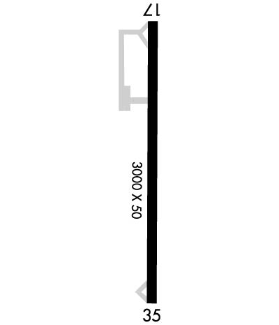
  • Runway Identifications
    Runway Identification: 17/35
    Length: 3000 ft
    Width: 50 ft
    Surface: CONCRETE-FAIR CONDITION
    Edge lights: Non-Standard Lighting System

    Treatment: NONE

     Runway: 17   Runway: 35
    Mag heading: 178°Mag heading: 358°
    Rwy Slope: -.43% DownRwy Slope: .43% Up
    Approach: Approach:
    Pattern: Left TrafficPattern: Left Traffic
    Markings: NONPRECISION INSTRUMENTMarkings: NONPRECISION INSTRUMENT
    Marking Condition: FAIRMarking Condition: FAIR
    Arresting Dev: Arresting Dev:
    Lat & Long: N4322.4  W09545.6Lat. & Long.: N4321.9  W09545.6
    Elev: 1535.8 ft. MSLElev: 1522.8 ft. MSL
    TCH: 31 ft. AGLTCH: 20 ft. AGL
    Visual Glide Path: 3.00 degreesVisual Glide Path: 3.00 degrees
    Displaced Threshold: NoDisplaced Threshold: No
    Touchdown Zone: YESTouchdown Zone: YES
    Touchdown Elev.: 1537.7 feetTouchdown Elev.: 1537.7 feet
    Visual Glide Slope: 2-Light PAPI on LEFT side of RunwayVisual Glide Slope: 2-Light PAPI on LEFT side of Runway
    RVR Equipment: RVR Equipment:
    RVV Equipment: NORVV Equipment: NO
    Approach Lights: Approach Lights:
    REIL: NOREIL: NO
    Centerline Lights: NOCenterline Lights: NO
    Touchdown lights: NOTouchdown lights: NO
    Runway Category: Runway with a Non-precision ApproachRunway Category: Runway with a Non-precision Approach
    Declared Distances: Declared Distances:
    Obstructions: ROADObstructions: TREES
    Marked: NOT Marked/LightedMarked: NOT Marked/Lighted
    Clearance slope: 21:1Clearance slope: 20:1
    Obstruction height: 15 feet AGLObstruction height: 77 feet AGL
    Dist. from runway: 515 feetDist. from runway: 1787 feet
    Centerline offset: 206 right of centerlineCenterline offset: 51 feet right of centerline
    Comments: Comments:
    C:/P: