Current Weather/Notams (Metars, TAFs, Notams, NWS Forecast, PIREPS, and nearby weather)
Customs Information Send updates to Support@FltPlan.com
Customs Not Available
Database effective 05/16/2024
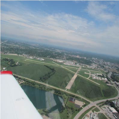
Airport Diagram might not be current.
|
| Facility Name: | IOWA CITY MUNI |
| City Name: | IOWA CITY |
| County: | JOHNSON |
| State abbrev: | IA |
| State Name: | IOWA |
| | |
| Ownership: | PUBLICLY OWNED |
| Use: | OPEN TO THE PUBLIC |
| Owner's Name: | CITY OF IOWA CITY |
| Address: | 410 EAST WASHINGTON |
| | IOWA CITY, IA 52240 |
| Owner's Phone: | 319-356-5010 |
| | |
| Manager's Name: | MICHAEL THARP |
| Address: | 1801 S. RIVERSIDE |
| | IOWA CITY, IA 52246 |
| Phone: | 319-356-5045 |
| | |
| FAA Region: | CENTRAL |
| FAA Field Office: | NONE |
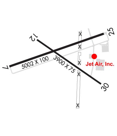
Runway Identifications
Runway Identification: 07/25Length: 5002 ft
Width: 100 ft
Surface: CONCRETE-GOOD CONDITION
Edge lights: Medium IntensityTreatment: GROOVED
Weight: PCN 15 /R/C/W/T
| | Runway: 07 | | Runway: 25 |
| Mag heading: | 72° | Mag heading: | 252° |
| Rwy Slope: | -.66% Down | Rwy Slope: | .66% Up |
| Approach: | | Approach: | |
| Pattern: | Right Traffic | Pattern: | Left Traffic |
| Markings: | NONPRECISION INSTRUMENT | Markings: | NONPRECISION INSTRUMENT |
| Marking Condition: | FAIR | Marking Condition: | FAIR |
| Arresting Dev: | | Arresting Dev: | |
| Lat & Long: | N4138.3 W09133.5 | Lat. & Long.: | N4138.6 W09132.4 |
| Elev: | 683.7 ft. MSL | Elev: | 650.5 ft. MSL |
| TCH: | 51 ft. AGL | TCH: | 38 ft. AGL |
| Visual Glide Path: | 3.50 degrees | Visual Glide Path: | 3.00 degrees |
| Displaced Threshold: | No | Displaced Threshold: | 130 feet |
| Touchdown Zone: | YES | Touchdown Zone: | YES |
| Touchdown Elev.: | 683.7 feet | Touchdown Elev.: | 658.8 feet |
| Visual Glide Slope: | 4-Light PAPI on LEFT side of Runway | Visual Glide Slope: | 4-Light PAPI on LEFT side of Runway |
| RVR Equipment: | | RVR Equipment: | |
| RVV Equipment: | NO | RVV Equipment: | NO |
| Approach Lights: | | Approach Lights: | |
| REIL: | YES | REIL: | YES |
| Centerline Lights: | NO | Centerline Lights: | NO |
| Touchdown lights: | NO | Touchdown lights: | NO |
| Runway Category: | Runway with a Visual Approach | Runway Category: | Runway with a Non-precision Approach having visibility minimums greater than 3/4 mile |
| Declared Distances: | TORA:5002' TODA:5152' ASDA:5002' LDA:5002' | Declared Distances: | TORA:5002' TODA:5002' ASDA:5002' LDA:4872' |
| Obstructions: | POLE | Obstructions: | TREE |
| Marked: | NOT Marked/Lighted | Marked: | NOT Marked/Lighted |
| Clearance slope: | 21:1 | Clearance slope: | 16:1; RY 25 APCH SLOPE 23:1 TO DSPLCD THLD. |
| Obstruction height: | 88 feet AGL | Obstruction height: | 46 feet AGL |
| Dist. from runway: | 2079 feet | Dist. from runway: | 950 feet |
| Centerline offset: | 263 right of centerline | Centerline offset: | 50 feet left of centerline |
| Comments: | | Comments: | |
Runway Identification: 12/30Length: 3900 ft
Width: 75 ft
Surface: CONCRETE-FAIR CONDITION
Edge lights: Medium IntensityTreatment: GROOVED
Weight: PCN 6 /R/C/W/T
| | Runway: 12 | | Runway: 30 |
| Mag heading: | 126° | Mag heading: | 306° |
| Rwy Slope: | -.32% Down | Rwy Slope: | .32% Up |
| Approach: | | Approach: | |
| Pattern: | Right Traffic | Pattern: | Left Traffic |
| Markings: | NONPRECISION INSTRUMENT | Markings: | NONPRECISION INSTRUMENT |
| Marking Condition: | FAIR | Marking Condition: | FAIR |
| Arresting Dev: | | Arresting Dev: | |
| Lat & Long: | N4138.5 W09133.2 | Lat. & Long.: | N4138.1 W09132.5 |
| Elev: | 661.3 ft. MSL | Elev: | 648.7 ft. MSL |
| TCH: | | TCH: | |
| Visual Glide Path: | | Visual Glide Path: | |
| Displaced Threshold: | No | Displaced Threshold: | No |
| Touchdown Zone: | YES | Touchdown Zone: | YES |
| Touchdown Elev.: | 661.3 feet | Touchdown Elev.: | 657.0 feet |
| Visual Glide Slope: | | Visual Glide Slope: | |
| RVR Equipment: | | RVR Equipment: | |
| RVV Equipment: | NO | RVV Equipment: | NO |
| Approach Lights: | | Approach Lights: | |
| REIL: | NO | REIL: | NO |
| Centerline Lights: | NO | Centerline Lights: | NO |
| Touchdown lights: | NO | Touchdown lights: | NO |
| Runway Category: | Runway with a Visual Approach | Runway Category: | Runway with a Non-precision Approach having visibility minimums greater than 3/4 mile |
| Declared Distances: | | Declared Distances: | |
| Obstructions: | TREE | Obstructions: | TREE |
| Marked: | NOT Marked/Lighted | Marked: | NOT Marked/Lighted |
| Clearance slope: | 14:1 | Clearance slope: | 13:1 |
| Obstruction height: | 85 feet AGL | Obstruction height: | 84 feet AGL |
| Dist. from runway: | 1454 feet | Dist. from runway: | 1327 feet |
| Centerline offset: | 25 left of centerline | Centerline offset: | 409 feet left of centerline |
| Comments: | | Comments: | |