Current Weather/Notams (Metars, TAFs, Notams, NWS Forecast, PIREPS, and nearby weather)
Customs Information Send updates to Support@FltPlan.com
Customs Not Available
Database effective 04/18/2024
Airport Diagram might not be current.
|
| Facility Name: | WINSLOW-LINDBERGH RGNL |
| City Name: | WINSLOW |
| County: | NAVAJO |
| State abbrev: | AZ |
| State Name: | ARIZONA |
| | |
| Ownership: | PUBLICLY OWNED |
| Use: | OPEN TO THE PUBLIC |
| Owner's Name: | CITY OF WINSLOW |
| Address: | 21 WILLIAMSON AVE |
| | WINSLOW, AZ 86047 |
| Owner's Phone: | 928-289-2422 |
| | |
| Manager's Name: | TIM WESTOVER; ALTERNATE CONTACT: ORVILLE WISEMAN, FBO, 928-289-0100. |
| Address: | 21 WILLIAMSON AVE |
| | WINSLOW, AZ 86047 |
| Phone: | (928) 289-2422 |
| | |
| FAA Region: | WESTERN-PACIFIC |
| FAA Field Office: | PHX |
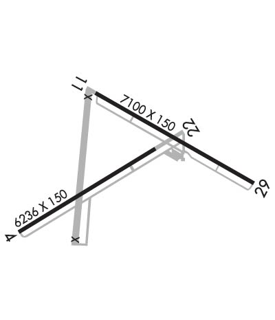
Runway Identifications
Runway Identification: 04/22Length: 7499 ft
Width: 150 ft
Surface: ASPHALT-GOOD CONDITION
Edge lights: Medium IntensityTreatment: NONE
| | Runway: 04 | | Runway: 22 |
| Mag heading: | 45° | Mag heading: | 225° |
| Rwy Slope: | -.80% Down | Rwy Slope: | .80% Up |
| Approach: | | Approach: | |
| Pattern: | Left Traffic | Pattern: | Left Traffic |
| Markings: | NONPRECISION INSTRUMENT | Markings: | NONPRECISION INSTRUMENT |
| Marking Condition: | FAIR | Marking Condition: | FAIR |
| Arresting Dev: | | Arresting Dev: | |
| Lat & Long: | N3500.9 W11044.3 | Lat. & Long.: | N3501.5 W11043.0 |
| Elev: | 4941.1 ft. MSL | Elev: | 4881.1 ft. MSL |
| TCH: | | TCH: | 40 ft. AGL |
| Visual Glide Path: | | Visual Glide Path: | 3.00 degrees |
| Displaced Threshold: | No | Displaced Threshold: | 1262 feet |
| Touchdown Zone: | YES | Touchdown Zone: | YES |
| Touchdown Elev.: | 4941.1 feet | Touchdown Elev.: | 4914.2 feet |
| Visual Glide Slope: | | Visual Glide Slope: | 4-BOX VASI ON LEFT SIDE OF RUNWAY |
| RVR Equipment: | | RVR Equipment: | |
| RVV Equipment: | NO | RVV Equipment: | NO |
| Approach Lights: | | Approach Lights: | |
| REIL: | NO | REIL: | YES |
| Centerline Lights: | NO | Centerline Lights: | NO |
| Touchdown lights: | NO | Touchdown lights: | NO |
| Runway Category: | Runway with a Visual Approach | Runway Category: | Runway with a Visual Approach |
| Declared Distances: | LDA:7499' | Declared Distances: | LDA:6236' |
| Obstructions: | | Obstructions: | TREE |
| Marked: | | Marked: | NOT Marked/Lighted |
| Clearance slope: | 20:1 | Clearance slope: | 1:1; APCH RATIO, 50:1 TO DTHR. |
| Obstruction height: | | Obstruction height: | 18 feet AGL |
| Dist. from runway: | | Dist. from runway: | 219 feet |
| Centerline offset: | | Centerline offset: | |
| Comments: | | Comments: | 15 FT DITCH, 15 FT FROM THLD, ACROSS THE APPROACH. |
Runway Identification: 11/29Length: 7100 ft
Width: 150 ft
Surface: ASPHALT-FAIR CONDITION
Edge lights: Medium IntensityTreatment: NONE
| | Runway: 11 | | Runway: 29 |
| Mag heading: | 106° | Mag heading: | 286° |
| Rwy Slope: | -.41% Down | Rwy Slope: | .41% Up |
| Approach: | | Approach: | |
| Pattern: | Right Traffic | Pattern: | Left Traffic |
| Markings: | NONPRECISION INSTRUMENT | Markings: | NONPRECISION INSTRUMENT |
| Marking Condition: | FAIR | Marking Condition: | FAIR |
| Arresting Dev: | | Arresting Dev: | |
| Lat & Long: | N3501.7 W11043.7 | Lat. & Long.: | N3501.2 W11042.4 |
| Elev: | 4899.3 ft. MSL | Elev: | 4870.0 ft. MSL |
| TCH: | 36 ft. AGL | TCH: | 28 ft. AGL |
| Visual Glide Path: | 3.00 degrees | Visual Glide Path: | 3.00 degrees |
| Displaced Threshold: | No | Displaced Threshold: | 344 feet |
| Touchdown Zone: | YES | Touchdown Zone: | YES |
| Touchdown Elev.: | 4899.4 feet | Touchdown Elev.: | 4882.6 feet |
| Visual Glide Slope: | 4-BOX VASI ON LEFT SIDE OF RUNWAY | Visual Glide Slope: | 4-BOX VASI ON LEFT SIDE OF RUNWAY |
| RVR Equipment: | | RVR Equipment: | |
| RVV Equipment: | NO | RVV Equipment: | NO |
| Approach Lights: | | Approach Lights: | |
| REIL: | YES | REIL: | NO |
| Centerline Lights: | NO | Centerline Lights: | NO |
| Touchdown lights: | NO | Touchdown lights: | NO |
| Runway Category: | Runway with a Non-precision Approach having visibility minimums greater than 3/4 mile | Runway Category: | Runway with a Visual Approach |
| Declared Distances: | LDA:7100' | Declared Distances: | LDA:6756' |
| Obstructions: | TREE | Obstructions: | FENCE |
| Marked: | NOT Marked/Lighted | Marked: | NOT Marked/Lighted |
| Clearance slope: | 24:1; CLEARANCE SLOPE TO DISPLACED THRESHOLD IS 50:1 | Clearance slope: | |
| Obstruction height: | 17 feet AGL | Obstruction height: | 8 feet AGL |
| Dist. from runway: | 618 feet | Dist. from runway: | 201 feet |
| Centerline offset: | 118 left of centerline | Centerline offset: | 75 feet right of centerline |
| Comments: | | Comments: | APPX 8 FT FENCE 200 FT FROM RWY END; ACROSS RWY END. APPX 2-TO-3 FT BRUSH, 0-TO-200 FT FROM THLD ACROSS RWY END. |

